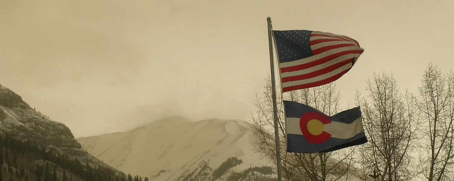
Greetings from Silverton,
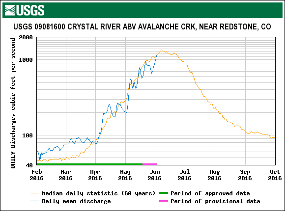
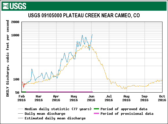
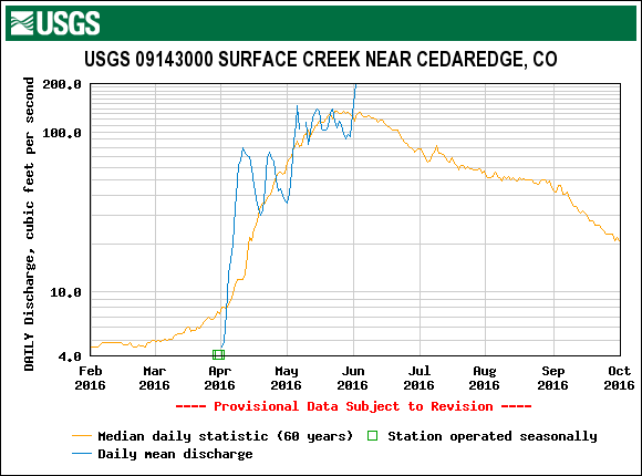
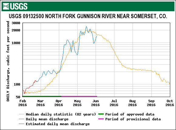
The past 6 days has seen an uptick in streamflow (some streams seeing close to double their median discharge) due to the warm/sunny conditions throughout most of Colorado with melt rates being exacerbated due to dust event D3 and/or D4 being located at the surface of the snowpack. Around Red Mountain Pass, D3 and D4 are now merged in many locations and very close to merged at Swamp Angel. During this time there have been a couple of windy days with gusts in the 20-30 mph range in the desert southwest, four corners region. On Friday, April 14, these winds created enough disturbance to create a haze event in southwest Colorado. Any dust that fell on the snow surface from this haze is likely negligible, as well as indecipherable with D3/D4 being located on the surface. But, it is worth mentioning since these seemingly small events do incrementally add to the total dust load on the snow surface and contribute to further reduction of surface albedo.
The forecast the next ~10 days is calling for a series of Pacific storms moving across the inter-mountain west. Today winds will remain out of the southwest with strong gusts up north and lessening in the south, and warm temperatures continuing. On Tuesday clouds will increase in the afternoon and bring chance of showers and maybe a few thunderstorms. Snow levels could be in the 9,000' range Tuesday night. Late Wednesday could see moderate accumulation in northern Colorado mountains and light accumulation in the central and southern mountains. Another, slightly colder, system is due to move in Thursday thru Saturday continuing the chance of mountain snow and rain in the lower elevations. All told, these systems are expected to bring periods with cloud cover and chance of precipitation, when these conditions occur will serve to lessen the solar energy input on the snowpack and possibly even cover the snow surface with clean, fresh snow, temporarily restoring high albedo to the snow surface.
Summary
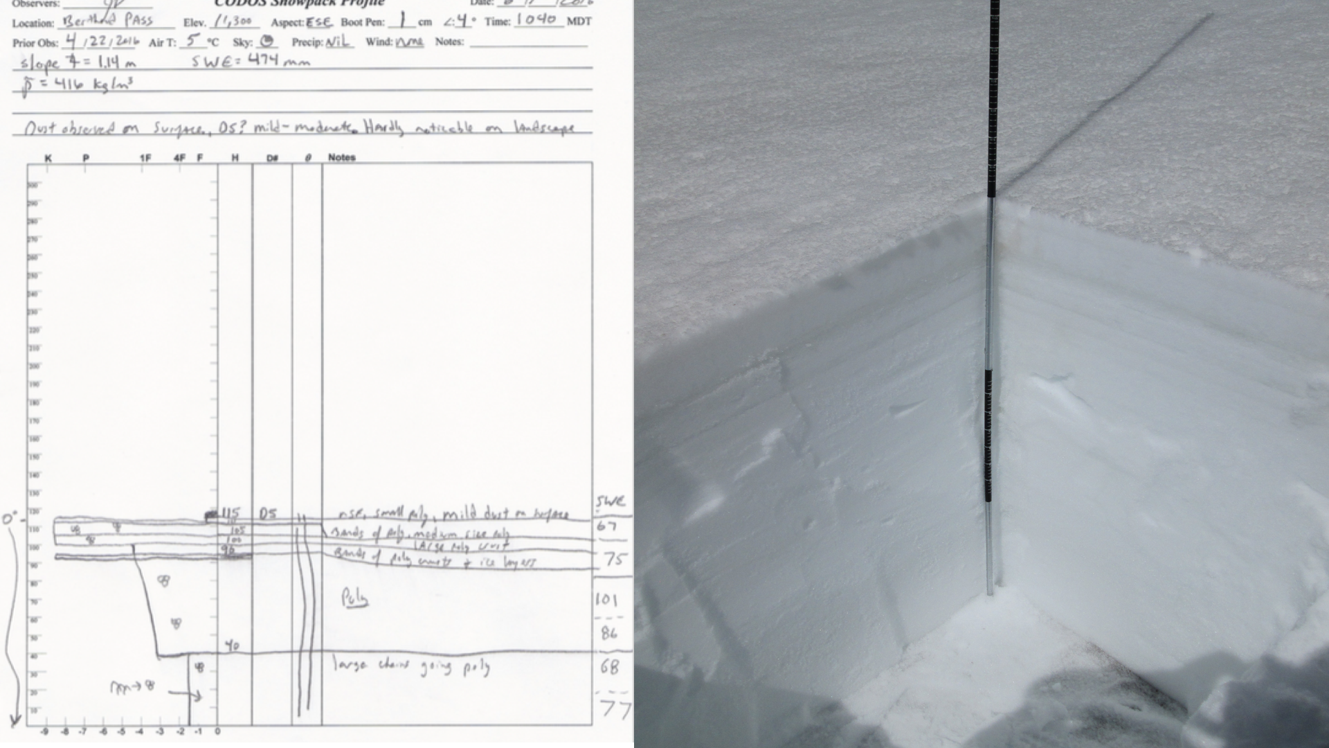
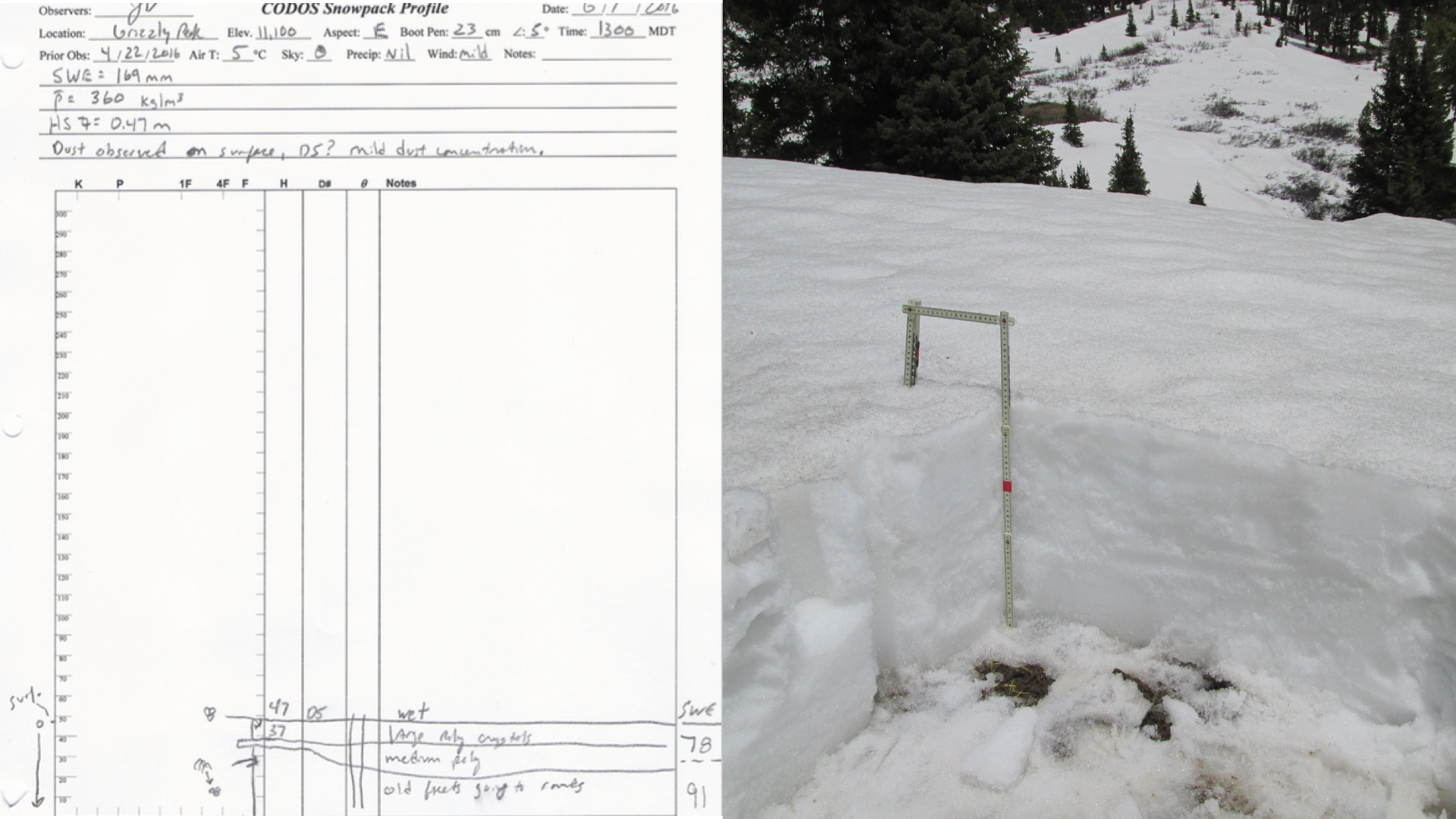
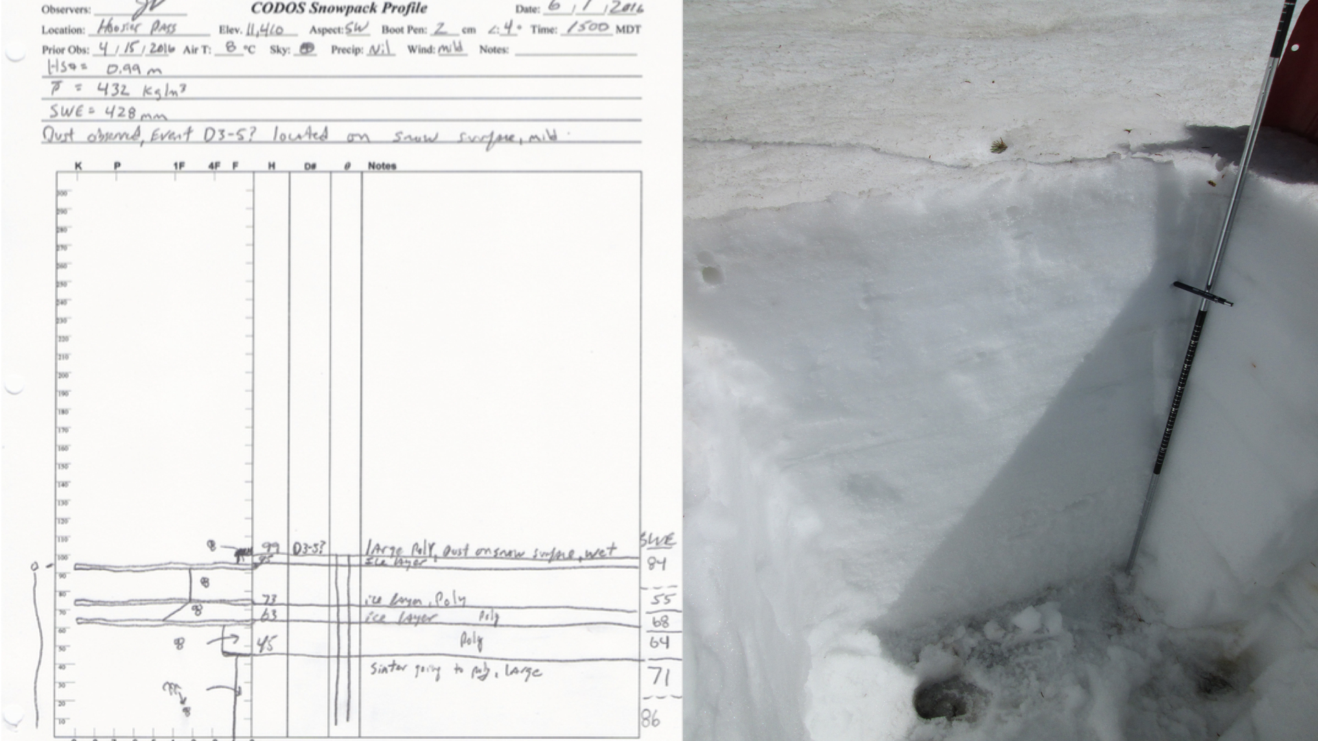
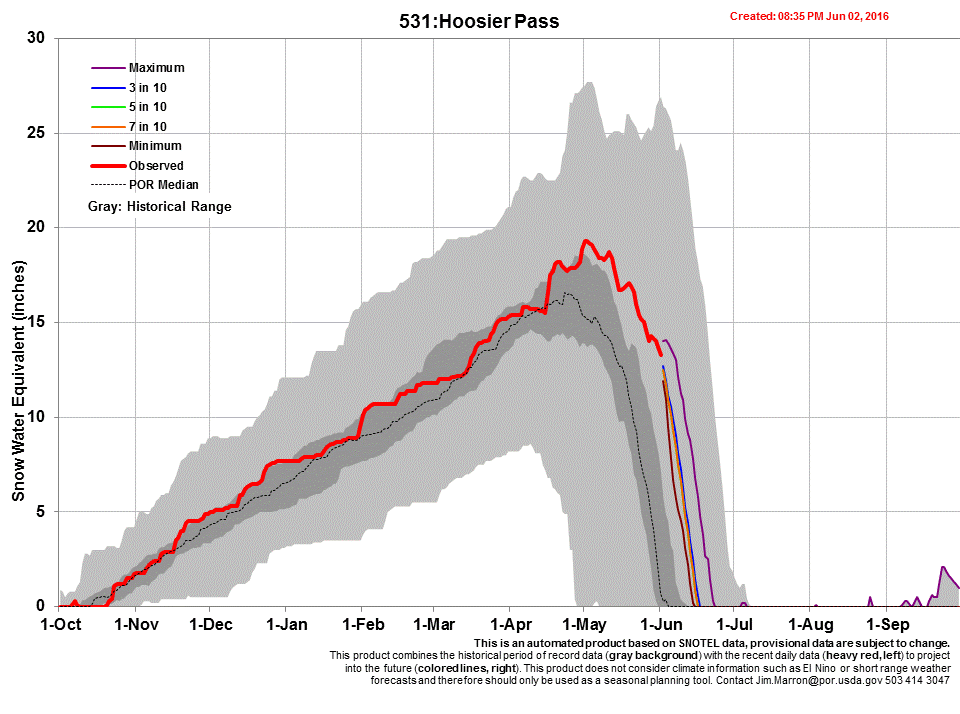
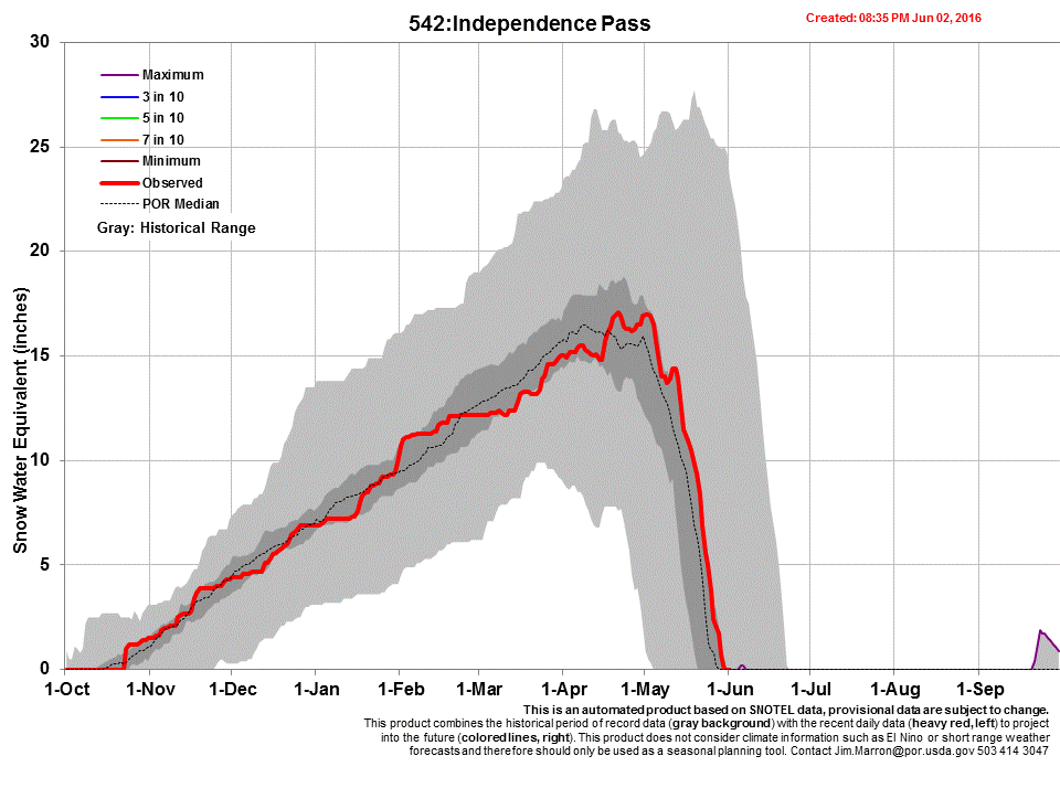
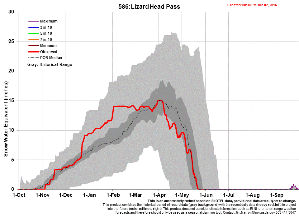
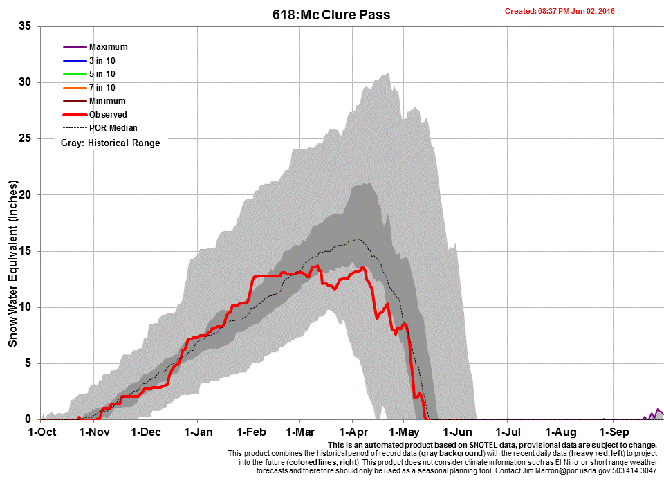
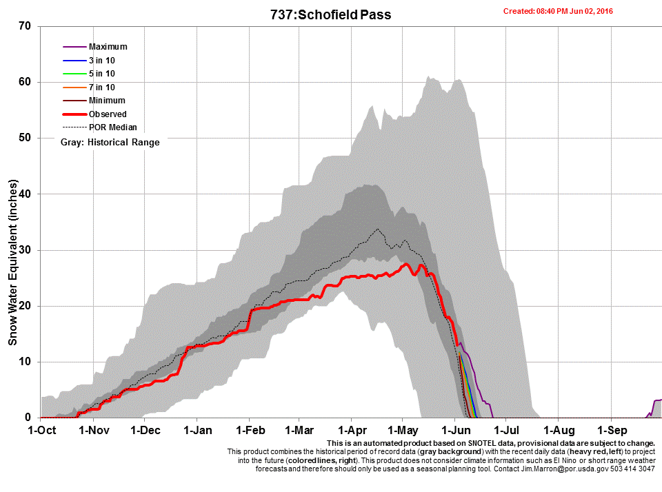
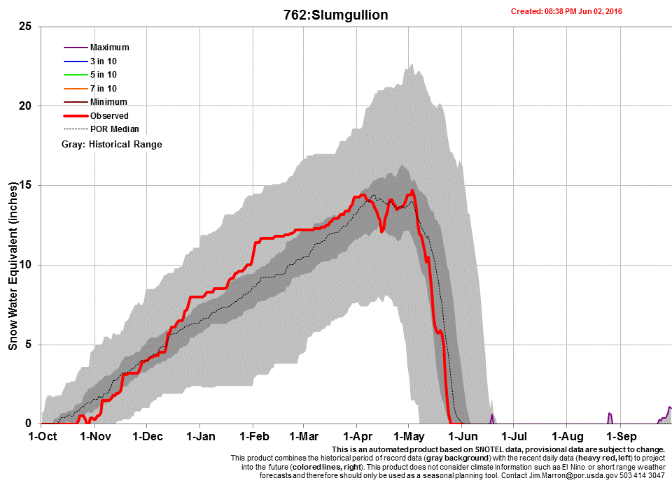
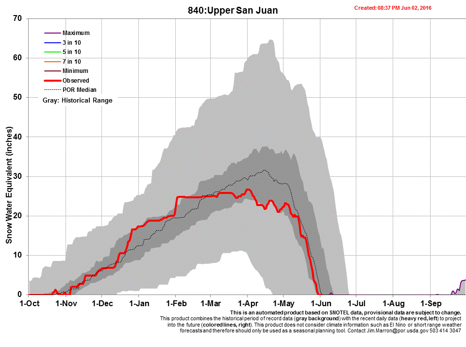
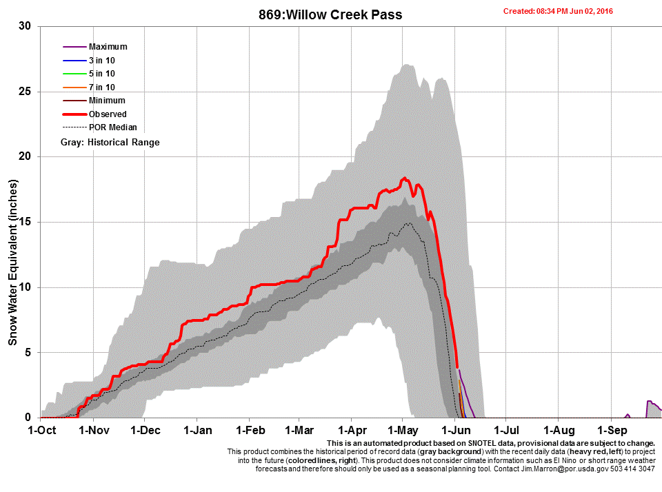
The CSAS team conducted the April CODOS tour April 7-9. Dust event D3 is within the top 12” of the snowpack at the majority of CODOS sites, and as we were finishing the tour dust event D4, a dry deposition event that occurred April 9, was observed at Red Mt. Pass and Grande Mesa. Judging by its intensity and the fact that it made it to Grande Mesa indicate chances are highly likely it is also at Wolf Creek, Spring Creek, Park Cone and McClure Pass. Being the last storm system we received, and also being a mostly dry event, it is currently on the surface of the snowpack where it was deposited. Locations that appeared to be dust free on April 9 are Willow Creek Pass and Berthoud Pass. Loveland Pass received D1/D2 events but appears to not have received D3 or D4. Hoosier Pass escaped D3 but it is uncertain if D4 reached that locale.
At the onset of spring all of our CODOS sites boasted healthy above average snowpacks. Over our past two CODOS tours we have seen snowpack declines at many sites, with some significant losses in snow depth and snow water equivalent (SWE). Losses between the two CODOS tours were especially apparent at lower elevation sites and at sites with more dust deposition or dust at the surface of the snowpack.
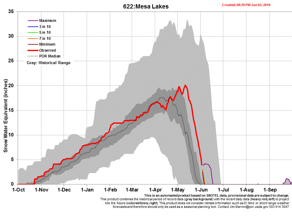
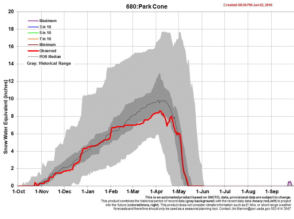
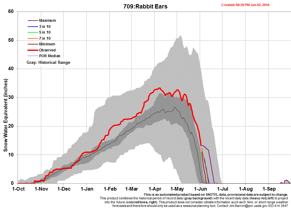
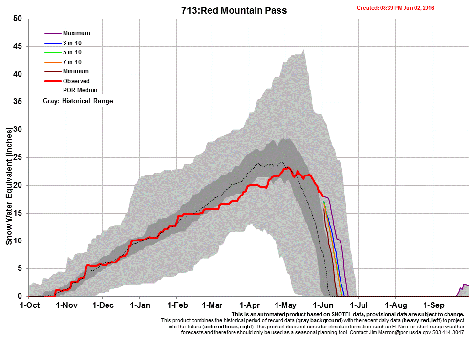
We are posting the snow profiles collected and new photos on each CODOS site’s webpage, as well as hydrographs and SWE graphs. Below you will also find a summary table and brief discussion for each CODOS location. Using the Dust Enhanced Runoff Classification (DERC) approach, links to hydrographs of the CODOS sites from WY2006-2016 are collated and presented to help with ascertaining what this Spring runoff scenario might look like. We anticipate at least one additional circuit of our ten CODOS sites this season as well as intensive monitoring at Senator Beck Basin (SBB).
Greetings from Silverton.
CSAS was on the road over this past weekend for our second CODOS tour of the season. We will be releasing a full report on this data collection trip in the next couple days, but for the time being we have received another dust event at our Senator Beck Basin Study Area in the San Juan Mountains.
Our fourth dust event of the year was a moderate dry event, lasting approximately 21 hours. The majority of the dust was likely deposited toward the end of this period. Currently dust is most apparent on North and East facing slopes in leeward areas where air tends to recirculate when wind blows over the landscape. The dust is also highly visible in other small surface features such as old ski tracks and tree wells.
Winter storm #22 is now at its end and it was evident at the onset of the storm that this precipitation was accompanied by our third dust event of the season.
D3 was a “wet” event (occurring with precipitation) that began March 30th at 1500 and lasted 15 hours, ending at 0500 on March 31st. The dust is pinkish-red in color was deposited in a very visible layer that is diffuse in the lower 2-3 cm of snow from winter storm #22. Winds during the event were largely from the south and southwest. This is our most visible dust event so far this season, and likely our largest by mass load as well.
The set-up of the storm currently passing through Colorado was perfect for bringing dust to the Colorado snowpack. Dust event #2 (D2) hit the San Juan Mountains near Red Mountain Pass yesterday, March 23. Like D1, this event came with snowfall and is difficult to currently see, being diffuse in the new snow accumulation. The wonderfully productive storm that brought dust also deposited 18" of snow containing 1.5" water at SASP. We will elaborate on this dust event as conditions unfold and ascertain the spatial extent during out next CODOS tour in mid-April. Since the majority of the dust likely came at the beginning of the storm, it won't take long to blend with D1 once the snow warms and consolidates. And fortunately for the time-being we have 18" of new snow covering D1 and most of D2. Eventually, the dust will become more prominent and concentrated at the surface when sunny conditions return.
Along with this dust event, finally, we are seeing a reprieve from the dry, warm, and sunny stretch of weather we have been experiencing since the last storm (and dust event) March 5-6. Even though we have only logged one moderate dust event prior to today, when the dust is exposed on the surface of the snowpack like D1, it only serves to increase the absorption of solar radiation that contributes to warming/melting the snowpack. This is the time of year when we play the "albedo reset" game, where we pray for new snowfall to cover dust accumulated at the surface of the snowpack, to keep the albedo (or reflectance) of the snow surface high, thereby slowing warming and subsequent melting of the snowpack. At the least we are grateful to see cloudy, overcast conditions that limit the amount of incoming solar radiation.
SUMMARY
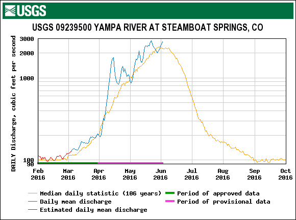
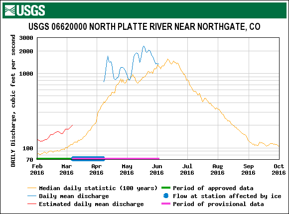
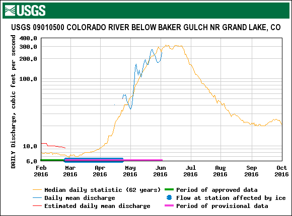
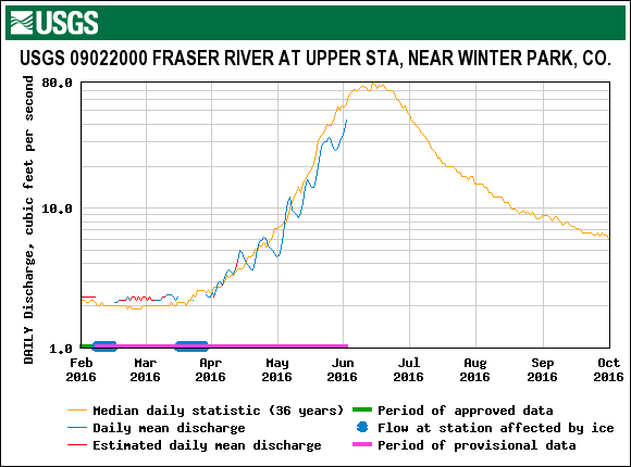
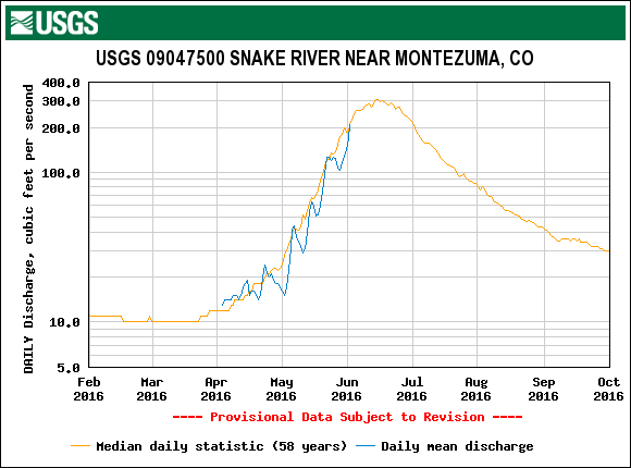
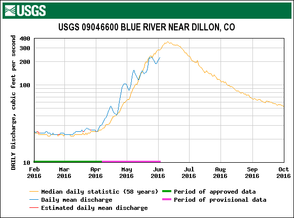
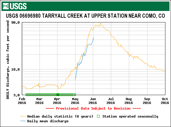
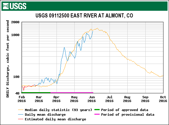
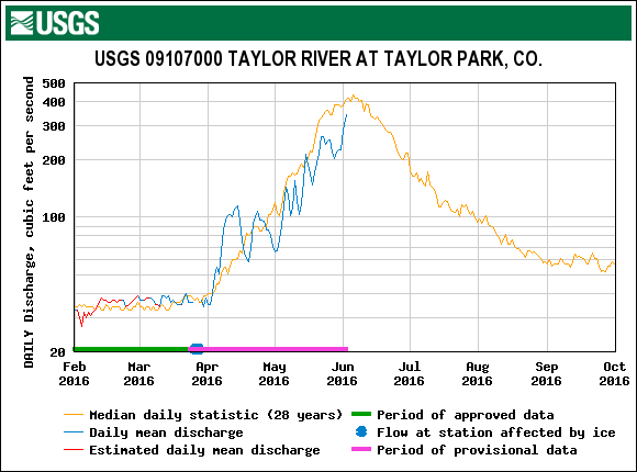
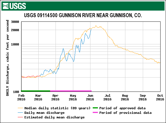
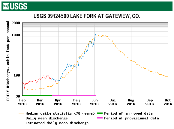
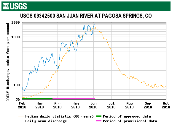
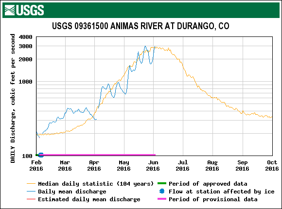
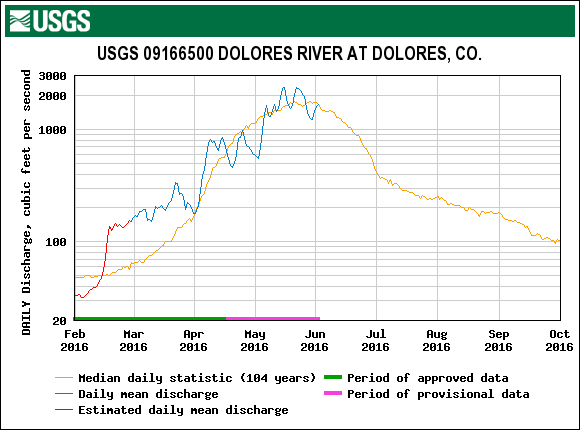
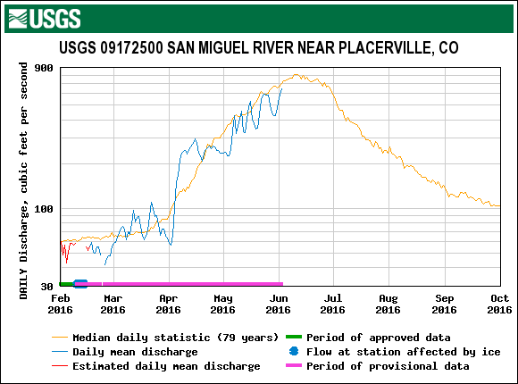
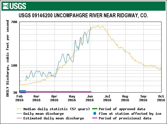
A storm on March 5th brought Colorado’s first dust-on-snow event of WY2017 (D1-WY2017). Winds up to 100 mph were recorded in the San Juan Mountains. The preceding months experienced a large number of high wind events, but the March 5th event contained the right elements to mobilize dust in the source area and transport it to the Colorado Mountains. From March 13-14 CODOS personnel toured our 11 samples sites around the state documenting the presence/absence of dust. Dust was observed at 7 CODOS sites, following a general south to north gradient of moderate intensity at SASP, Wolf Cr., Spring Cr., Park Cone, McClure Pass, Hoosier Pass, and Loveland Pass. Dust was not apparent at Grand Mesa, Rabbit Ears Pass, Willow Cr. Pass, and Berthoud Pass. With the continuous dry, warm, and sunny conditions since March 5th, and the forecast indicating more of the same, combined with D1 being located on the surface of the snowpack increasing the absorption of solar radiation, sets up the conditions where the snowpack has experienced accelerated warming and melt, which will continue until the next chances of precipitation and cooler weather arrive. SNOTEL station snow water equivalent (SWE) data indicate major basins in Colorado are still in the “High” category, as defined by the CODOS Dust Enhanced Runoff Classification (DERC “Average” equals day median +/- 10%). For gauging stations that are active this time of year, streamflow is showing an early season uptick in response to the last ten days of sunny/warm conditions. In the southern part of Colorado some streams are running double their median discharge for this time of year, with two stations (Dolores at Dolores, San Juan at Pagosa) showing flows close to 4 times their normal rate.
Greetings from Silverton,
After a number of days since a storm that brought very high winds straight out of the desert southwest, dust is starting to show itself in some areas around the San Juan Mountains. Observers reported dust mobilization in the source region, as far North as the Mexican Water/Kayenta country all the way down to Cameron, at the beginning of the storm on March 5. With these field reports along with the high winds at Senator Beck we were fulling expecting to be reporting on Dust Event #1 immediately following the storm. Initially however, the landscape, and snow profiles at SASP (and elsewhere) failed to show dust.
In the Northern San Juans, this mild and diffuse dust event is still not yet showing on many NW-N aspects or in snow profiles at SASP, but has started to show on the surface of sunnier slopes where warming over last 5 days has allowed it to concentrate at the surface. And it is more evident in "eddy" locations throughout the landscape.
Samples of this "wet" event (occurring with precip) have been collected and we will report the mass loading from this event soon. As mentioned a few days ago, the CODOS team will conduct the state-wide sampling tour starting on Monday and will report findings soon after.
February 26 marked the final day of the NASA sponsored SnowEx campaign in Senator Beck Basin. SnowEx, which included an intensive snow data collection effort February 6-10 and February 20-26 in SBB, is a multi-year project aimed at developing a snow-sensing satellite to measure snow water equivalent on a global scale. During the study period, airborne snow measurements using many different instruments and methods were conducted over SBB. While measurements were being made from the air, scientists on the ground collected snowpack information to "ground-truth" airborne data (https://snow.nasa.gov/snowex).
Over 30 snow pits were excavated throughout the entire Basin to assess snowpack variables, including depth, density, SWE, temperature profile, grain types, and layer hardness. Summary data from these snow profiles are now included in the March 1st Update on the CODOS website (http://www.codos.org/codosupdates/mar12017). If you would like more information about this data please contact me. Please keep in mind this is preliminary data and subject to corrections.
SUMMARY
Colorado has begun March with “high” conditions completely dominating the range of snowpack conditions among major basins across the Colorado Mountains. This update summarizes snowpack conditions state-wide and evaluates March 1st snow water equivalent (SWE) data from SNOTEL stations associated with our eleven CODOS sites and places them within the framework of the Dust Enhanced Runoff Classification scheme (DERC) developed by CODOS. A summary is presented by individual Basin, and provides a site-specific analyses for each CODOS site (linked below).
Dust Free So Far and Healthy Snowpack
Greetings From Silverton,
Despite a dry and lackadaisical start to winter, persistent snowcover in Senator Beck occurred on November 21, we have seen a major turn-around with a steady stream of productive storms. We have received eight winter storms so far (Storm #8 Report will follow shortly) that in and of themselves have totaled ~10.0" of water. Snow depth at Swamp Angel is at 4.5’ and the wind effected Senator Beck site is lingering around 1.5’.
Greetings from Silverton, Colorado -
I hope our readers had a very enjoyable summer/fall. The summer flew by here at Center for Snow and Avalanche Studies catching up on projects that got pushed aside while we were monitoring the spring snowpack, performing summer station maintenance, and preparing for the coming winter. I was hoping this beginning of the snow season update would coincide with a storm report detailing a big event to kick off WY2016. But, unfortunately the month of October in the San Juan Mountains has been a bit dry. Measured precipitation the month of October at the Swamp Angel Study Plot in our Senator Beck Study Basin (SBSB) was 0.75 (19 mm). At Red Mountain SNOTEL, located exactly 1-mile the way the crow flies, measured precipitation was 0.60" (15 mm). We saw some nice precipitation events in August and September, some of which included snow at higher elevations but have since melted. These Aug/Sept precipitation events resulted in bumps in streamflow higher than the norm, but currently we are seeing discharge a tad below normal. Concurrently, soil moisture conditions are in lower percentiles throughout most of the State.
The result of a “Godzilla” El Nino year was basically an overall average statewide snowpack. The entire state started off WY2016 with a bang building the snowpack at a higher rate than average Oct/Nov/Dec/Jan. In February conditions took a turn for the worse with dry/warm weather lasting until mid-March for northern Colorado, and being much more severe and lasting until latter March for southern Colorado. Northern locales recovered nicely from this dry stretch but the Rio Grande, Gunnison, and Animas/Dolores struggled the remainder of the season. The month of May was generally overcast, cooler than average, and brought multiple precipitation events, putting a damper on snowmelt until conditions turned very warm the very end of May. Many streams in southern Colorado saw peak discharge, well above their median values, around the June 5-10 timeframe.
Greetings from Silverton,
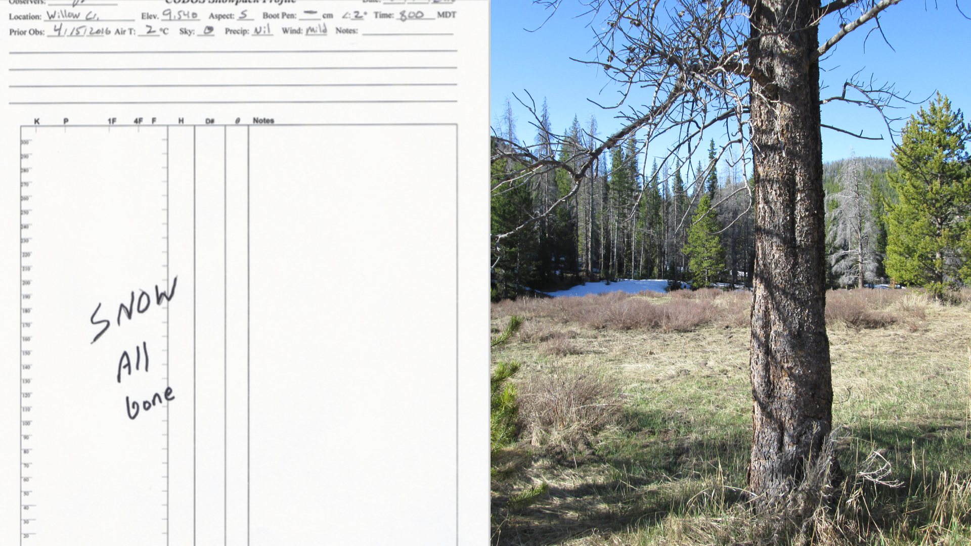
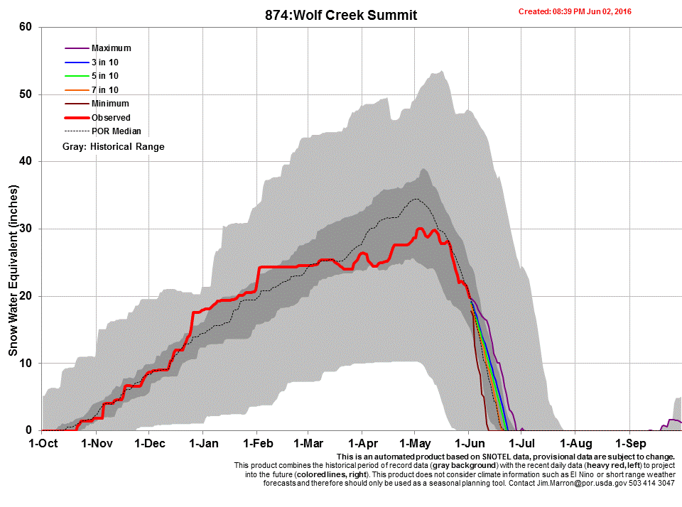
Site visits to CODOS study plots at Grand Mesa on June 7, Swamp Angel Study Plot (SASP) on June 9, and Wolf Creek on June 10, revealed snow-all-gone (SAG) at all locations. As the photos shown below illustrate, snow is either totally gone (Wolf Cr.) or exists only in thin, patchy areas. Snow is mostly present in heavily treed areas and higher elevations, and predominately on northerly aspects. All dust layers are merged at the surface of the snow. Just like the other CODOS sites with dust, an “all-layers-merged” (ALM) sample was collected at each of these locations and sent to our USGS collaborators for chemical analyses for inter-site comparison.
Greetings from Silverton,
Together, with the emergence of D5/D6 as reported in the May 22 Update, along with the subsequent sunny and warm weather that followed, the snowpack at SASP has quickly melted to where dust layers D2-D6 are now merged at the surface.
As mentioned in the May 16th Update, dust event #5 (D5) and #6 (D6) for WY2016 was ~4” beneath the snow surface at our Swamp Angel Study Plot (SASP), with full dust emergence being noted for some time at lower elevations and higher southerly aspects in the San Juan Mountains and Gunnison Basin.
Over the past week, with the passing of unsettled weather May 16-19, D5/D6 are now emerged at SASP. Meltwater and rain caused a fair bit of dust leaching downward about 5” from the top of the snowpack. Regardless, with dust emergence snow albedo will be reduced accompanied with increased snow melt rates at these elevations (~11,060’). D4 is located directly underneath D5/D6, and even though has not fully merged with D5/D6, will do so very quickly. Albedo at SASP decreased a good deal since May 13 when I reported D6/D5 to be 11 cm (4”) under the surface. At that time mid-afternoon albedo at SASP was on average 60%, compared to 44%, today, May 22. With dust events D2-D6 occupying the top 35 cm (14”) of the snowpack, and with full emergence of D5/D6, snow surface albedo will continue to decline as the snow melts downward, accumulating dust layers D4, D3, and D2 at the surface of the snow, increasing melt rates as it progresses. The remaining 1.17 m (4’) of snow underlying D2 will melt under intensified dust enhanced conditions as D2-D6 are merged at the surface.
SUMMARY
Site visits were conducted at our Swamp Angel Study Plot (SASP) in Senator Beck Basin (SBB), Spring Creek Pass, Wolf Creek Pass, Park Cone, and McClure Pass CODOS monitoring sites (see a map of CODOS sites). Since mid-April we have seen further snowpack development due to a steady series of storm events. Late April and May snow accumulation at higher elevations has done a passable job of keeping majority of dust covered during the clear and sunny skies from May 1-5 and over the last few days (May 11-15). Lower elevations in the San Juan region are seeing dust events #5 and #6 (D5 and D6), and possibly D2-D4, fully exposed on the snowpack surface. The forecast for the Colorado Mountains over the next 4 days calls for at least a chance of precipitation with some locations (Breckenridge, Winter Park) under a winter weather advisory. Today, over the last 12 hours, we have received Storm #24 at SASP. Between April 12 and May 16, SASP has seen 22 days (22 days out of 35) with measurable precipitation.
DUST-ON-SNOW CONDITIONS
No new dust-on-snow events were observed at our SBB sentry site since the D6-WY2016 event on April 25 (see Dust Log). The total WY2016 mass of mineral dust deposited to-date at the SASP is 11.165 grams per square meter (11 g/m2), approximately similar loadings as WY2011 and WY2012 (see Mass Loading Data). June dust-on-snow events are comparatively rare, but we still have a couple weeks left in the month of May.
Greetings from Silverton,
We conducted the CODOS tour the middle of April and finished a few sites on April 22. Starting on April 25 (along with a D5 event on April 23 and D6 event on April 25) most of the Colorado mountains experienced a week of stormy weather that mostly arrested or slowed down snow melt as seen in many stream gauges. After these last few days of warm, sunny weather, we have seen an uptick of stream flow. Now, the forecast for the next 4-5 days is for increased cloud cover, a cooling trend, and chance of precipitation in the form of rain or snow at higher elevations. Depending on how much precipitation in the form of rain we receive, along with general weather conditions, will of course determine how much this uptick in stream discharge continues. Rain, especially if accompanied with a moist, warm air mass that sits on the snow, can increase the energy inputs and ramp up melt on an already ripe snowpack. When warm and sunny conditions return, southern Colorado where dust is at or near the surface of the snow, will see dust enhanced snow melt. Northern areas of Colorado, that have remained dust free since our last field observations in middle/latter April, will see a more "natural" snow melt scenario in terms of not being influenced by the increased solar absorption of dust on the snowpack surface.
Greetings from Silverton,
Dust event #6 was deposited as a wet event with the storm system arriving April 25-26 at Senator Beck Basin. It is an extremely faint event and was deposited with 2" of snow. This 2" band of snow is beneath ~2" of "clean" snow accumulated over the last few days. I did not attach any pictures showing D6 since it does not come across very noticeably. We have been working on Storm #20 here at SBB since Monday, April 25. The storm systems have been stacked on top of each other allowing no break in precipitation greater than 12 hours, which would define the end of a storm. For our purposes, a storm is defined as at least 12mm (0.47") of precipitation with no break greater than 12 hours.
Fortunately, much of the dust source area, in and around the Southern Colorado Plateau, has received some precipitation over the last few days (from Trace amounts in Winslow, AZ to ~0.33" in the Bluff, UT area) and the forecast calls for a chance of showers over the next 3 days. The majority of USGS dust camera images show trace snow and overcast/foggy conditions as of the morning of Friday, April 29. Hopefully enough precipitation has fallen to keep dust from mobilizing should these active storm tracks and winds speeds conspire to create another potential dust event.
Summary
The majority of the April CODOS tour was accomplished just prior to a significant closed low pressure system that set up over the four corners region and deposited at least 1” of precipitation at most CODOS sites across the state from April 15-17. We postponed visiting Grizzly Peak (Loveland Pass) and Berthoud Pass until the storm subsided and allowed safe travel (mainly from other motorists) to these sites.
Both Berthoud and Loveland Pass, as of April 22, were dust free. On April 14, Willow Creek and Rabbit Ears Pass were also dust free. If these four CODOS sample locations have not received dust from D5 – occurring Saturday, April 23 – then they remain the only CODOS locations in the state, to date, that will not have snowmelt impacted by dust.