

Greetings from Silverton,
As mentioned in the May 16th Update, dust event #5 (D5) and #6 (D6) for WY2016 was ~4” beneath the snow surface at our Swamp Angel Study Plot (SASP), with full dust emergence being noted for some time at lower elevations and higher southerly aspects in the San Juan Mountains and Gunnison Basin.
Over the past week, with the passing of unsettled weather May 16-19, D5/D6 are now emerged at SASP. Meltwater and rain caused a fair bit of dust leaching downward about 5” from the top of the snowpack. Regardless, with dust emergence snow albedo will be reduced accompanied with increased snow melt rates at these elevations (~11,060’). D4 is located directly underneath D5/D6, and even though has not fully merged with D5/D6, will do so very quickly. Albedo at SASP decreased a good deal since May 13 when I reported D6/D5 to be 11 cm (4”) under the surface. At that time mid-afternoon albedo at SASP was on average 60%, compared to 44%, today, May 22. With dust events D2-D6 occupying the top 35 cm (14”) of the snowpack, and with full emergence of D5/D6, snow surface albedo will continue to decline as the snow melts downward, accumulating dust layers D4, D3, and D2 at the surface of the snow, increasing melt rates as it progresses. The remaining 1.17 m (4’) of snow underlying D2 will melt under intensified dust enhanced conditions as D2-D6 are merged at the surface.
Areas that are still snow covered and where complete spatial dust emergence has not fully taken place are higher elevations and predominantly northerly aspects, roughly, elevations greater that ~11,700 (please see pictures below). Emergence will continue most quickly on solar (east, south, and west) aspects and more slowly on north-facing alpine terrain. In addition, day length and sun angles are increasing thereby increasing the potential amount of solar energy absorbed by dust at or just beneath the snowpack surface.
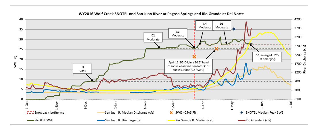
Similarly, the Wolf Creek CODOS snow profile shown on the May 16th Update discussed D5/D6 dust layers being 4” below the surface and D2-D4 4” below D5/D6, with dust visible just under the snow surface throughout the surrounding landscape. The warm weather that ensued following that profile assuredly initiated dust emergence in this locale to occur quickly. And, with the warmer/sunnier weather returning, and judging by Wolf Creek Summit SNOTEL data, D2-D6 are now merged at the surface.
Towards the north at Grand Mesa, judging by the location of dust layers during the April 14 visit and recent weather events, all dust layers are now fully emerged. In addition, the NEXRAD camera located on Grand Mesa at slightly over 10,000’ has shown dust emergence going on a few days now.
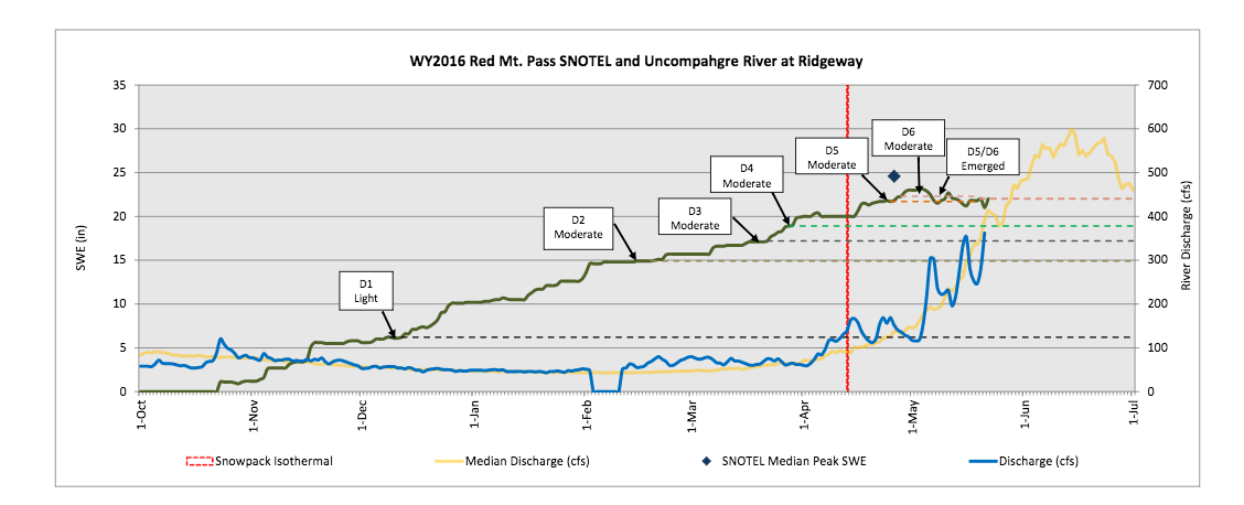
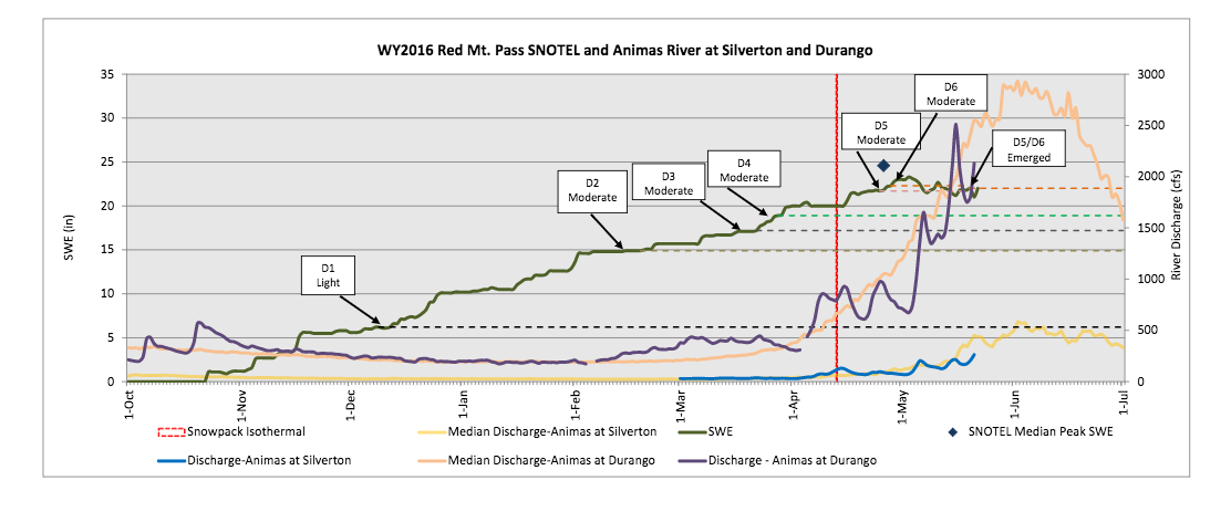
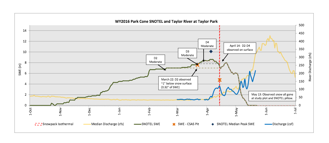
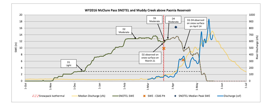
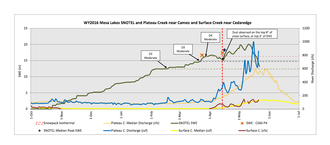
Hydrographs throughout the San Juan Mountains display several similar timed surging episodes on their ascending limbs, although those surges, and their subsequent retreats, were of high amplitude, the overall pattern and net discharge in the Animas, Dolores, Uncompahgre, Rio Grande, and San Juan watersheds tracked reasonably closely around median ascending limb levels. Most stream gauges in the San Juan Mountains recorded a decline in streamflow from May 16-18/19 in response to the recent stormy period, and, are now showing a start of an uptick over the last couple days. Unsettled weather may slightly subdue, but dust emergence will continue at higher elevations. The new snow accumulation at alpine locations will quickly melt as underlying dirty snow absorbs solar energy this week and runoff surging resumes (please see the SWE/streamflow/dust plots on our CODOS website). The 8-14 day outlook is indicating below normal temperatures and below normal chance of precipitation in southwest Colorado, but slightly higher than normal chance for precipitation throughout the rest of Colorado.
My eyes have been glued on the USGS dust-cams, UDOT, and CDOT cameras for indications of dust mobilization with the increased S-SW winds over the last couple days. The high winds are expected to continue into Tuesday night, we’ll keep you updated.
Central and Northern CODOS sites will be visited later this week to collect an all-layers-merged sample where dust is present and conduct another snow profile.
More Soon,
Jeff Derry
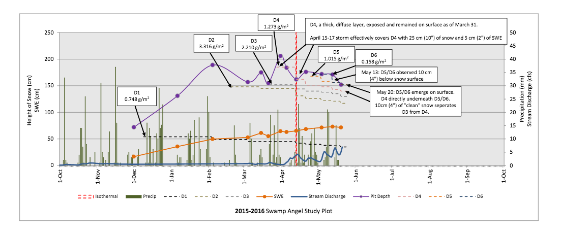
Snow profile at SASP on May 20. D5/D6 emerged with D4 sitting directly underneath, but has not fully merged with D5/D6. Some leaching of dust downward has taken place over last couple weeks due to meltwater and occasional rain. D4 is separated from D3 by a ~4” clean snow band.
Photo taken May 20 at SASP. Example of D5/D6 and possibly D4 emergence on all but northerly aspects around tree line (11,060’).
Photo taken May 20 near SASP. In the foreground the snow surface shows dust emergence. In the background dust mostly not emerged at higher elevations.
Photo taken May 21 near Molas Pass. Dust on surface where there is still snow cover in foreground, less so higher up.
Precipitation forecast for the next 7 days.
Precipitation forecast for the 8-14 day outlook.
Temperature forecast for the 8-14 day outlook