Greetings from Silverton,
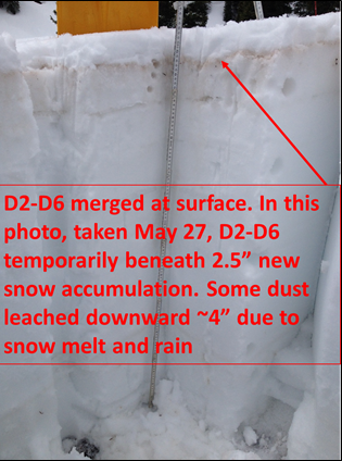
Together, with the emergence of D5/D6 as reported in the May 22 Update, along with the subsequent sunny and warm weather that followed, the snowpack at SASP has quickly melted to where dust layers D2-D6 are now merged at the surface.
Precipitation, much of it in the form of snow, fell on Thursday and Friday (May 26-27) at Senator Beck. The snow surface saw an albedo “reset” with D2-D6 being covered with ~2.5” of snow, temporarily slowing the rate of melt of the snowpack (see picture below). This new snow accumulation is longer lasting at higher, alpine snowcover, elevations and less long-lasting at lower elevation snowcover. At SASP this new snow has since ablated leaving D2-D6 fully exposed on the surface.
Looking ahead, the forecast calls for a high pressure gradually building with temperatures rising throughout the week and by the end of the week will average about 10° above normal. Conditions are also looking to be dry through next weekend. Please see 7-day precipitation forecast below.
More Soon,
Jeff Derry