
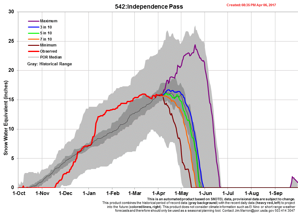
Summary
The CSAS team conducted the April CODOS tour April 7-9. Dust event D3 is within the top 12” of the snowpack at the majority of CODOS sites, and as we were finishing the tour dust event D4, a dry deposition event that occurred April 9, was observed at Red Mt. Pass and Grande Mesa. Judging by its intensity and the fact that it made it to Grande Mesa indicate chances are highly likely it is also at Wolf Creek, Spring Creek, Park Cone and McClure Pass. Being the last storm system we received, and also being a mostly dry event, it is currently on the surface of the snowpack where it was deposited. Locations that appeared to be dust free on April 9 are Willow Creek Pass and Berthoud Pass. Loveland Pass received D1/D2 events but appears to not have received D3 or D4. Hoosier Pass escaped D3 but it is uncertain if D4 reached that locale.
At the onset of spring all of our CODOS sites boasted healthy above average snowpacks. Over our past two CODOS tours we have seen snowpack declines at many sites, with some significant losses in snow depth and snow water equivalent (SWE). Losses between the two CODOS tours were especially apparent at lower elevation sites and at sites with more dust deposition or dust at the surface of the snowpack.
We are posting the snow profiles collected and new photos on each CODOS site’s webpage, as well as hydrographs and SWE graphs. Below you will also find a summary table and brief discussion for each CODOS location. Using the Dust Enhanced Runoff Classification (DERC) approach, links to hydrographs of the CODOS sites from WY2006-2016 are collated and presented to help with ascertaining what this Spring runoff scenario might look like. We anticipate at least one additional circuit of our ten CODOS sites this season as well as intensive monitoring at Senator Beck Basin (SBB).
Colorado Dust-on-Snow Conditions
Spring is ramping up and so are the dust events and their severity. The first two dust events of the season occurred on March 5 and March 23. These two events were so light that they were indistinguishable in the snow profiles at Swamp Angel (and a number of other CODOS sites) but were apparent after the warming snowpack coalesced the dust on the surface. D3 was a nasty, game changing, dust event that will have a significant role in melting the snowpack in locations such as the San Juan Mts, and even though reduced in intensity going towards the northern mountains (Park Cone, McClure, Grande Mesa) it will still influence snowmelt at these sites but to a lesser degree. For now we are classifying D3 as the upper end of “moderate” at SASP. It occurred on March 31st, and as of right now it is located in the top 12” of the snowpack at SASP and Wolf Cr where it is most intense, and at the surface at Grande Mesa and Spring Creek. To add to the D3 event, the last day of our CODOS tour (April 9) a large part of Colorado received dust event #4. This is also being considered a “moderate event” and is located at the surface of the snowpack wherever it was deposited. D4 was a “dry” event (transported and deposited without precipitation) in the San Juan Mountains and a mostly dry event at Grande Mesa. D4 was not observed at Rabbit Ears, Loveland Pass, Berthoud Summit, or Willow Creek during sampling activities on April 9.
The 18-day stretch of dry/warm weather the middle of March gave way to a series of nice storm events beginning March 23 provided nice additional accumulation to the snowpack and unseasonably cold temperatures, putting the brakes on further snowpack warming/melt. Now however, as of this writing dry conditions and warm air temperatures are expected to dominate the remainder of the week. Warmer than normal temperatures are expected to continue according to the short to long range forecasts (see forecast discussion below). With D3 and D4 both considered moderate intensity, and are either merged at the surface of the snowpack or just a few inches beneath the snow surface, combined with the NWS forecast of sunny, warm conditions, we can expect to see a return to rapid warming of the snowpack in the near-term (~10 days).
The arid dust source regions of the Four Corners area are also experiencing the onset of a major warming and drying period. Long-range regional predictions are for well-above average temperatures and average to below average chances for median precipitation. As spring moves forward we will be watching both the mountains and the desert for changes in dust and dust available for transport.
The table below summarizes dust events observed during the recent CODOS tour as well as a qualitative descriptor of total severity of dust-on-snow at each location. Considering this information along with March 1 SWE conditions and a current estimation of spring weather conditions, previous water year hydrographs are suggested as possibly meeting similar conditions as WY2017, and what the ensuing spring runoff might look like.
Table 1. Dust and snowpack conditions as of April 10, 2017, with current DERC categorization. Dust event #4 (D4) occurred on April 9, hence it is almost certain that this event is on the surface of the snowpack at locales likes Wolf Cr, Spring Cr, Park Cone, McClure. “Current DERC Spring Conditions” are characterizations of spring weather to date (March-April 10). If there are no previous water years in the DERC matrix to directly compare with WY2017, then these sites are noted in bold, and alternate water years are presented (or not at all for Berthoud) that may offer an idea of possible runoff scenarios that are close to current conditions.
STREAMFLOW
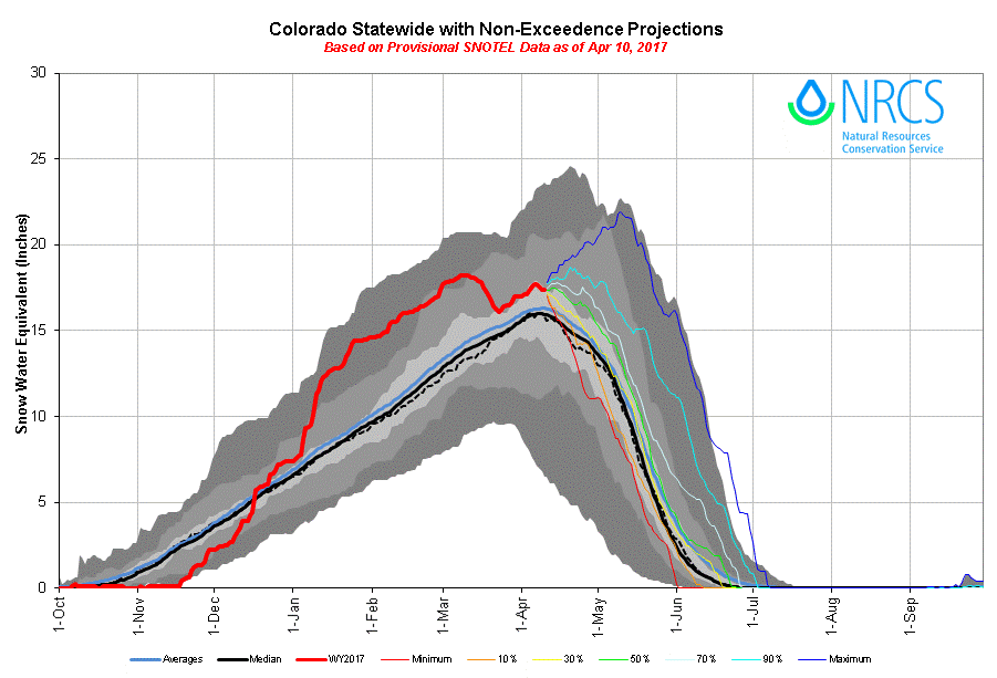
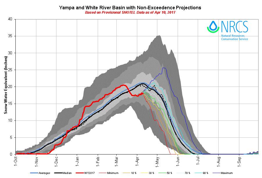
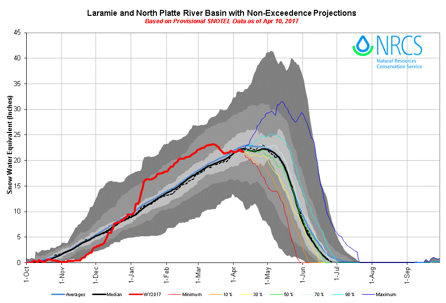
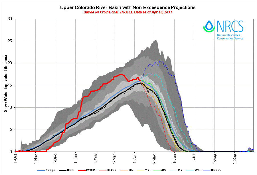
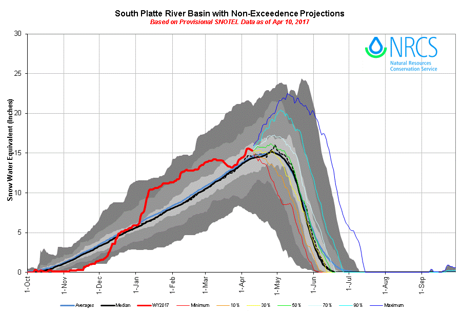
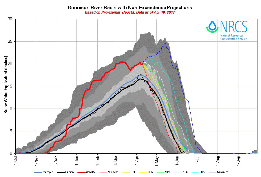
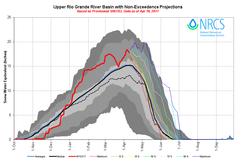
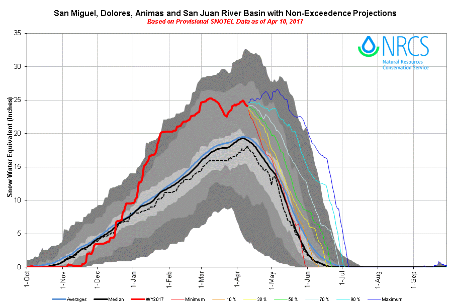
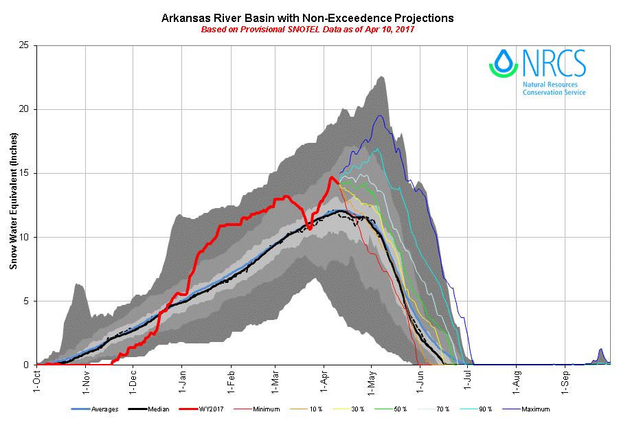
SWE Conditions
Basin SWE Conditions
Paired Profiles
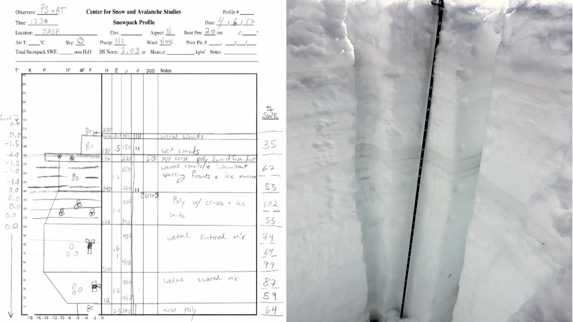
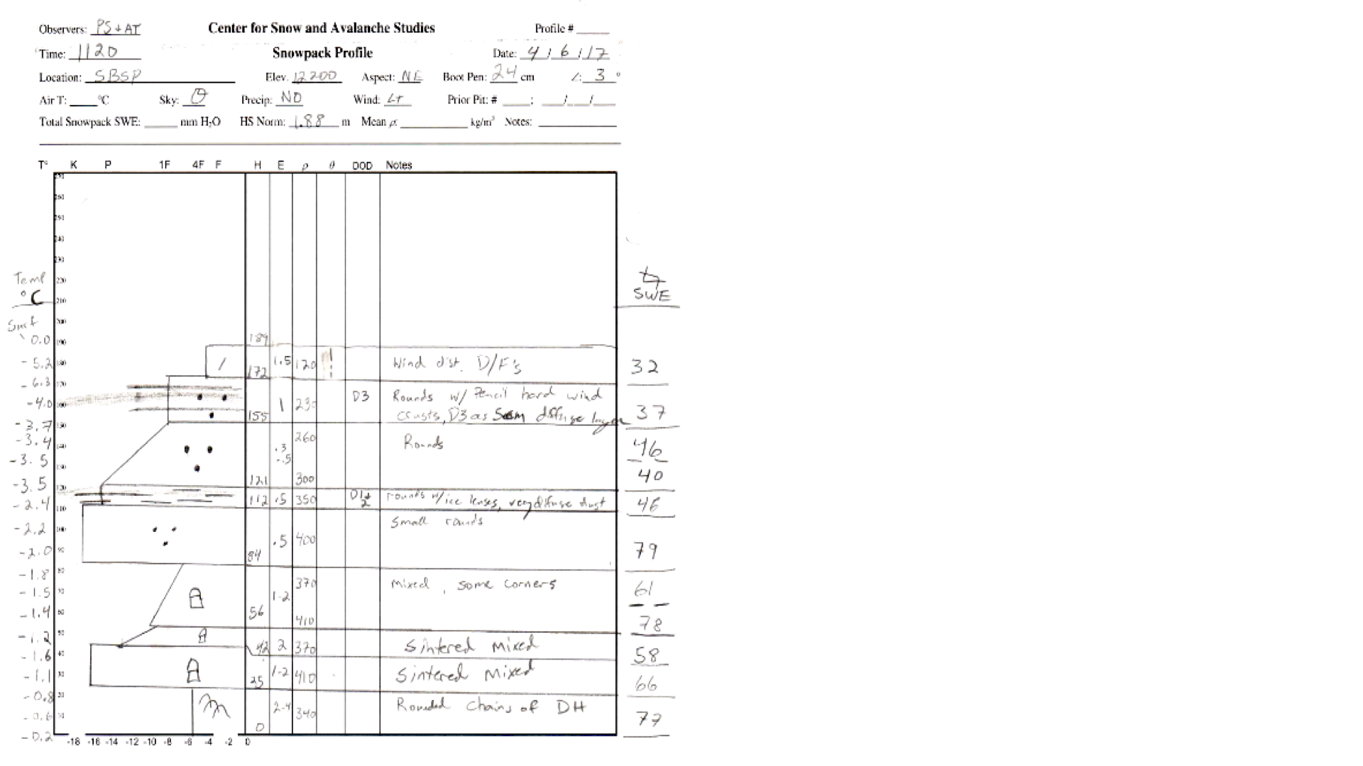
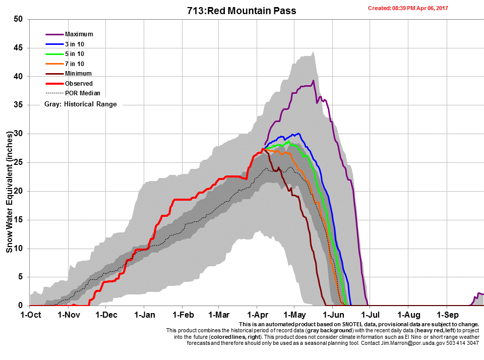
Senator Beck Basin – April 7
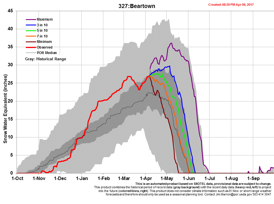
Like most of Colorado, snowpack (in the form of SWE) at Senator Beck Study Basin is still above average, steadily increasing (or rebounded in many locales) in SWE despite the 18-day dry/warm mid-March (see plots below). So far for WY2017, both SASP and SBSP are in the top 1/3 of highest snow accumulation years based on our period of record. As mentioned above, the dust season was slow to start with initially only two light events in March. But then on March 31 and again on April 9 we received two significant dust events. D4 is located at the surface of the snowpack and D3 is located 1’ below the surface. As warm/sunny conditions return to the forecast (they are upon us now), D4 will immediately enhance the absorption of solar radiation and increase snowpack warming and melt. Once D4 merges with D3, the combined effect will melt the snow at even higher rates, given the presence of warm/sunny conditions.
SWE plot at Swamp Angel Study Plot (11,060’). WY2017 is well above average based on our 14 dataset
SWE plot at Senator Beck Study Plot. Senator Beck Study Plot snowpack, located at 12,200’, still retains a good amount of cold content throughout profile, compared to lower elevation sites.
Snowmelt discharge rates spiked drastically in responds to the mid-March warming period, but dropped to near median levels due to a string precipitation events and unseasonably cold air temperatures the latter part of March. In our March 1st Update we posted the following analyses of WY2017 that narrowed the DERC domain based on prior Water Years. On March 1st, SNOTEL station data in the San Juan region was ranked as “High”, with “Average” current spring precipitation conditions, and “Average” dust conditions. There are no previous hydrographs that fit current conditions, other possible scenarios include WY ‘08/’09/’16.
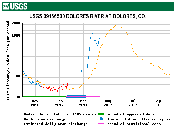
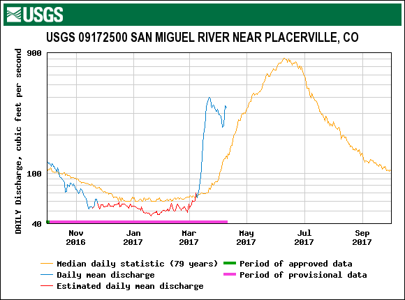
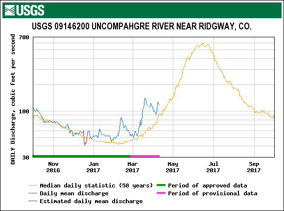
USGS gauge hydrographs from four watersheds, Animas River, Dolores River, San Miguel River, and Uncompahgre River for the CODOS WY2006-2016 period of record, are collated and presented in the DERC discussion on the SBB webpage. Below are hydrographs that pertain to “High” March 1 SWE conditions.
The March 31 dust event at Swamp Angel. Event D3 easily visible a few inches below surface
The April 9 D4 event near Swamp Angel Study Plot. D4 was a “dry” event, occurring without precipitation. Notice pink dust in ski track and covering landscape.
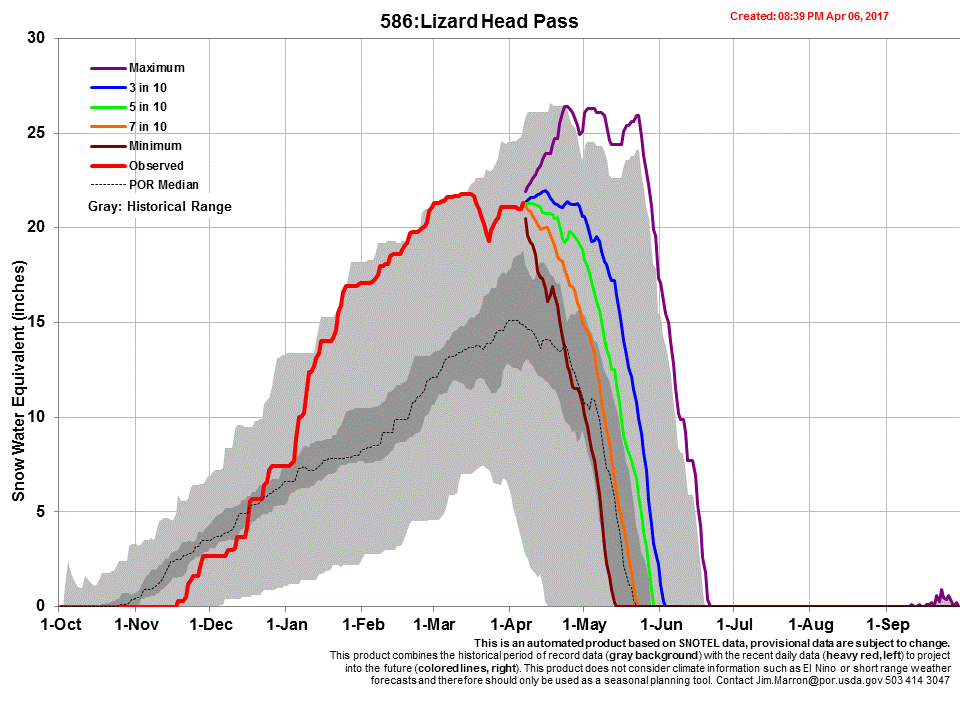
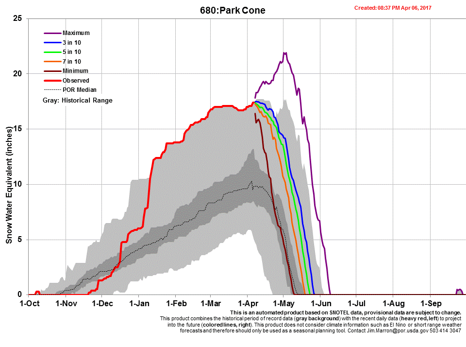
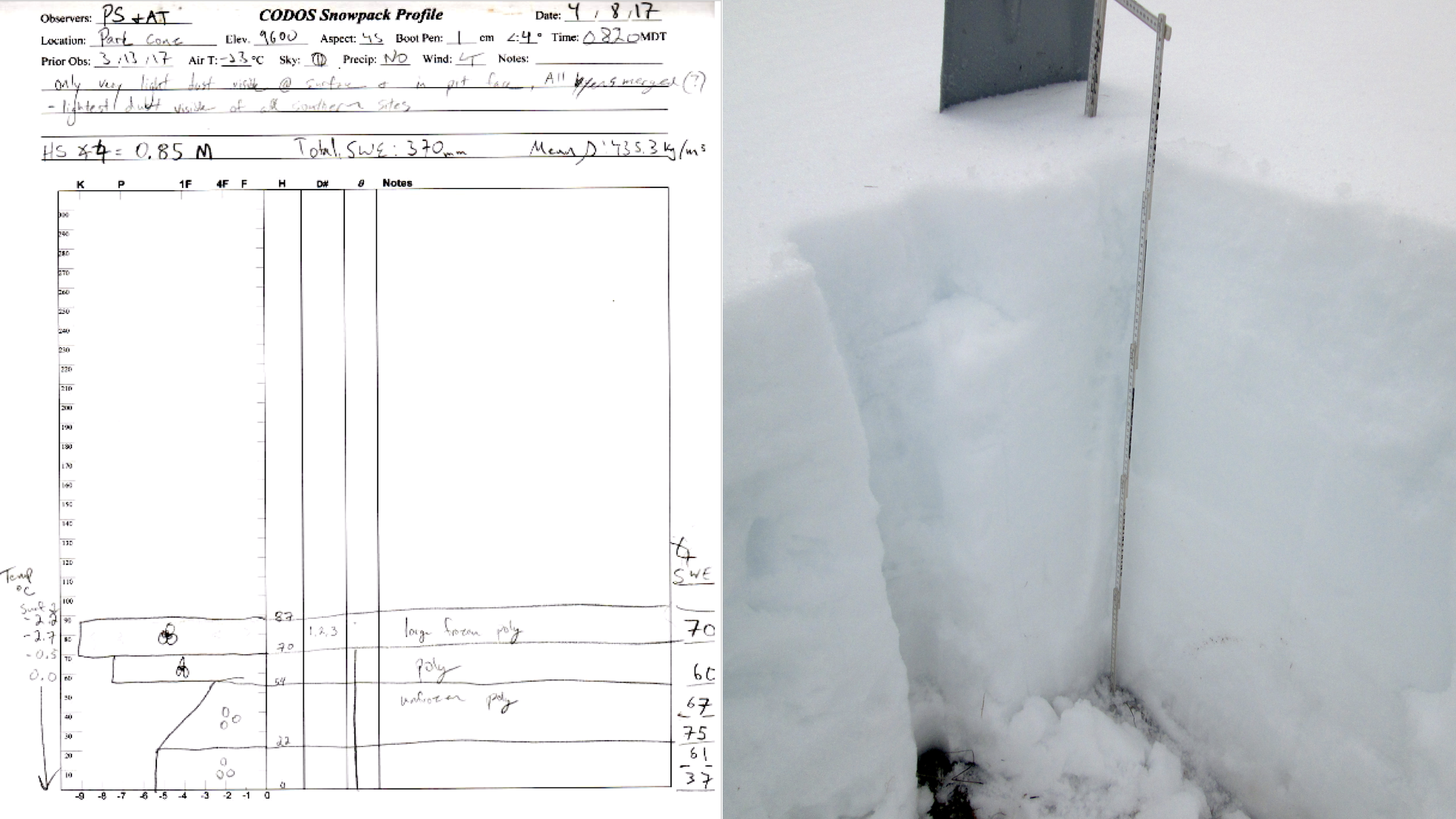
Park Cone – April 8
The snowpack at Park Cone was found to be significantly depleted from our last visit on March 13th, with 15% less SWE and 35% lower snow height. The snowpack is now isothermal at this site, with only the top 17cm refrozen snow holding any temperature gradient below zero from the night before.
The snowpack is composed entirely of large melt forms, or “polycrystals,” and was found to be wetted through it’s full depth (except where observed to have refrozen overnight). This is a typical springtime snowpack.
D1-3 were observed in a merged layer at the top of the snowpack. The possible presence of our recent D4 event is still unknown. This late in the season it is unlikely that these events will be buried under significant snow at this elevation, making a long term “albedo reset” unlikely. This, in addition to the isothermal nature of the snowpack and significant reductions in SWE and snow height, suggests that Park Cone is well into it’s springtime melt phase, and that further reductions in the snowpack can be expected as spring continues.
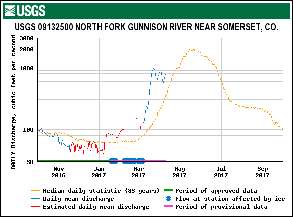
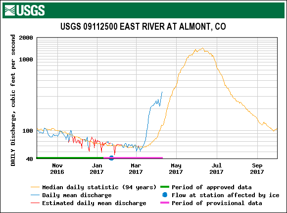
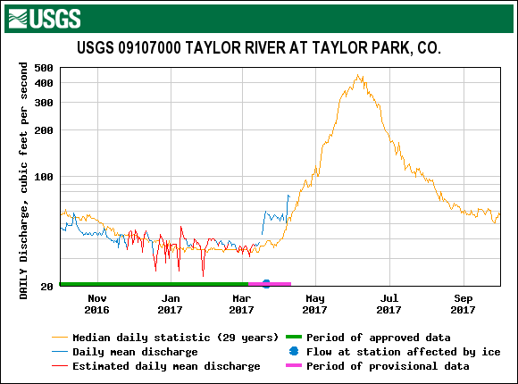
Park Cone is considered to have “High” March 1st SWE and to be having a “Dry” spring with “Average” dust under our DERC classification. See the below DERC slideshows to find hydrographs from similar years.
- Taylor River at Taylor Park (pdf)
- East River at Almont (pdf)
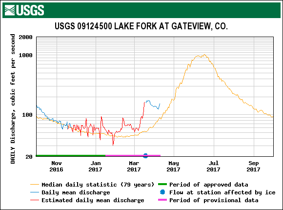
- Lake Fork at Gateway (pdf)
The Park Cone CODOS site is in an open, north-sloping meadow, uphill of the Park Cone snow course and adjacent to the Park Cone SNOTEL.
Some dust visible on the snow surface. Our April Pit is filled in in the foreground, with our March pit visible behind.
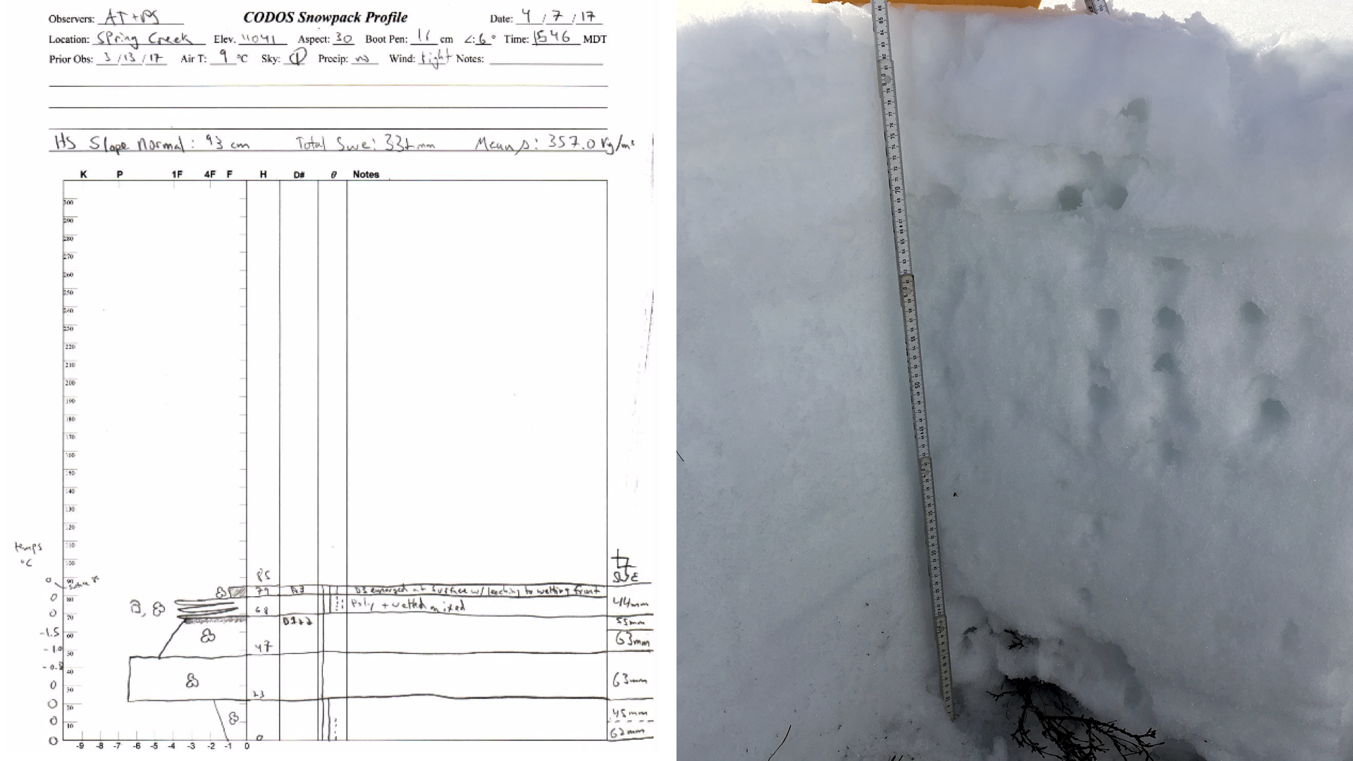
Spring Creek – April 7
The Spring Creek snowpack is mostly isothermal with highly visible dust presence both within the snowpack (D1+2) as well as merged on the surface (D3). The presence of our most recent event, D4, is as of yet unknown as the event occurred shortly after our CODOS visit. While snow height has marginally decreased since our mid-March visit, the site has gained more than an inch of SWE.
Snow at the site was found to be significantly wetted, indicating that the snowpack is in a “ripening phase,” when liquid water begins to fill pore space between frozen grains. This also indicates that a full isothermal snowpack is not far off, and that conditions for melt are well underway.
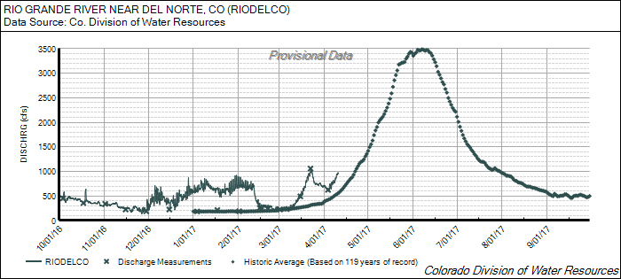
With the forecast showing a low likelihood for snow at the site, along with near isothermal snow temperatures and dust on the surface, it is reasonable to expect Spring Creek to begin rapidly lose it’s snowpack to runoff in the coming days to weeks. Park Cone is considered to have “High” March 1st SWE and to be having a “Dry” spring with “Average” dust under our DERC classification. See the below DERC slideshows to find hydrographs from similar years:
- Lake Fork at Gateview (pdf)
- Rio Grande near Del Norte (pdf)
Spring Creek CODOS site on April 7. D1/D2 are collected about 15cm deep in the snowpack, while D3 is at the surface.
Approaching the Spring Creek CODOS site, with D3 emerged and visible on the surrounding area.
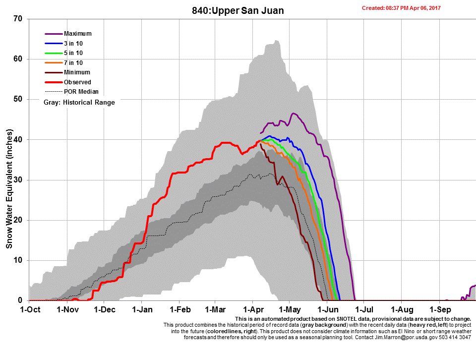
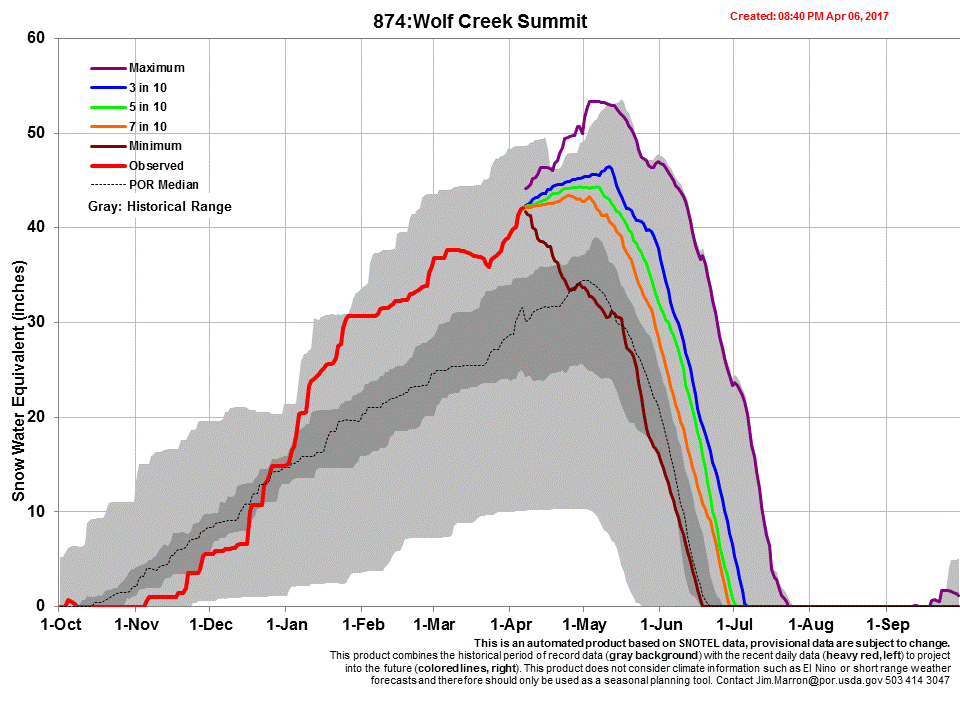
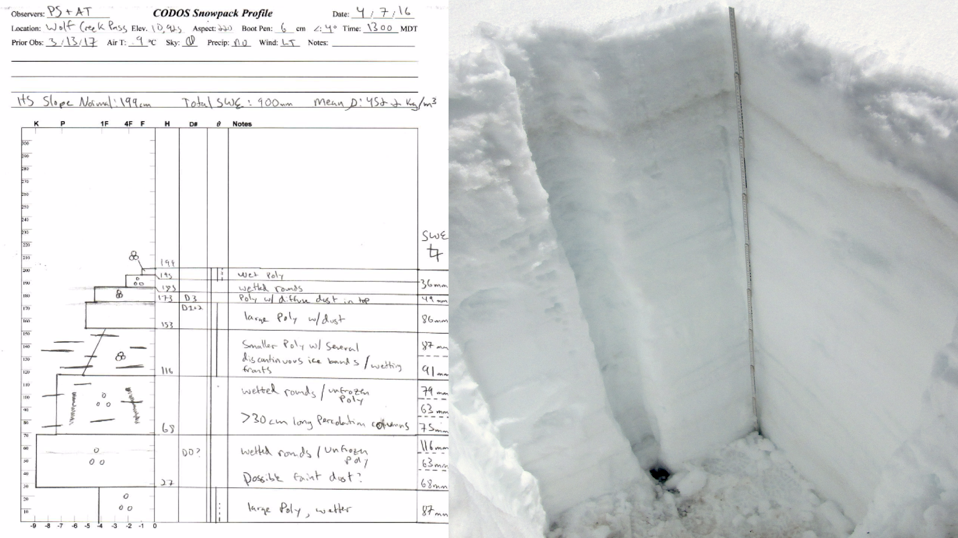
Wolf Creek Summit – April 7
The Wolf Creek Summit snowpack is still deep and wet, but has fully transitioned to isothermal and is moving into a melt phase. Moist to wet snow was observed throughout the snowpack, with the signs of melt very present. Refrozen percolation columns greater than 30cm in length were found in the pit wall, along with a complex series of wetting fronts and ice masses where liquid water had pooled near layer boundaries and other irregularities in the snowpack.
Wolf Creek is still our wettest site with 900mm (35.4 inches) of SWE. Although D1-3 are buried under our early-April snow, the forecasted warm temperatures may be enough to reveal the hidden dust. This, in addition to the possible surface presence of our recent D4, a dry event in Senator Beck Basin, could accelerate the ripening of the snowpack and increase runoff downstream.
Still, the snowpack is significant both in height and in SWE, so we expect snow to remain at our Wolf Creek CODOS site for a while yet. Within our DERC classification, Wolf Creek is classified as having “High” March 1st SWE, “Average” dust and “Dry” springtime precipitation. As runoff increases with the continuation of spring, see the below hydrographs for typical runoff patterns in similar years:
Wolf Creek Summit CODOS snow profile on April 7.
Snow cover is still significant in the Wolf Creek region, with little emerged dust and high SWE as of the April 7 CODOS visit
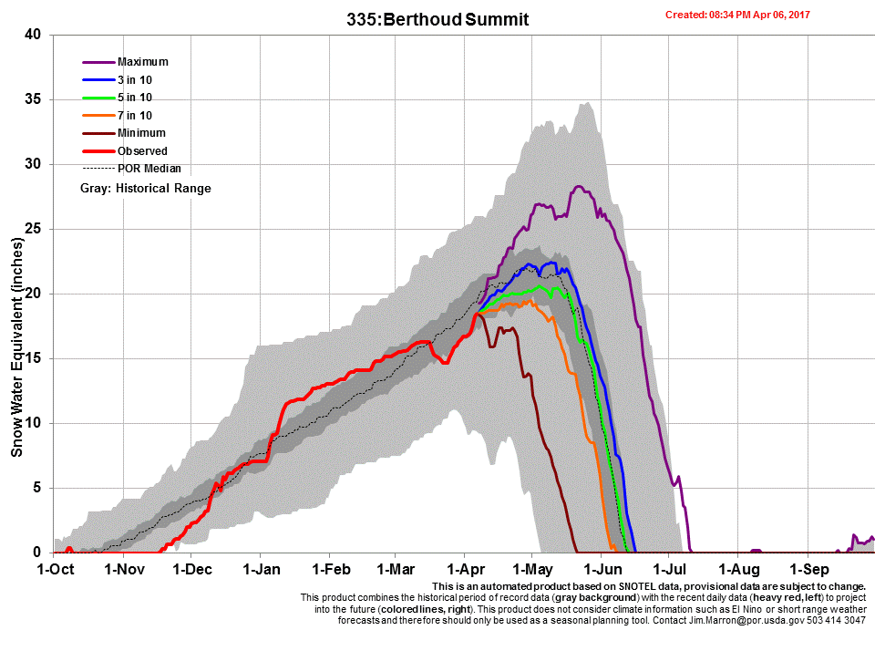
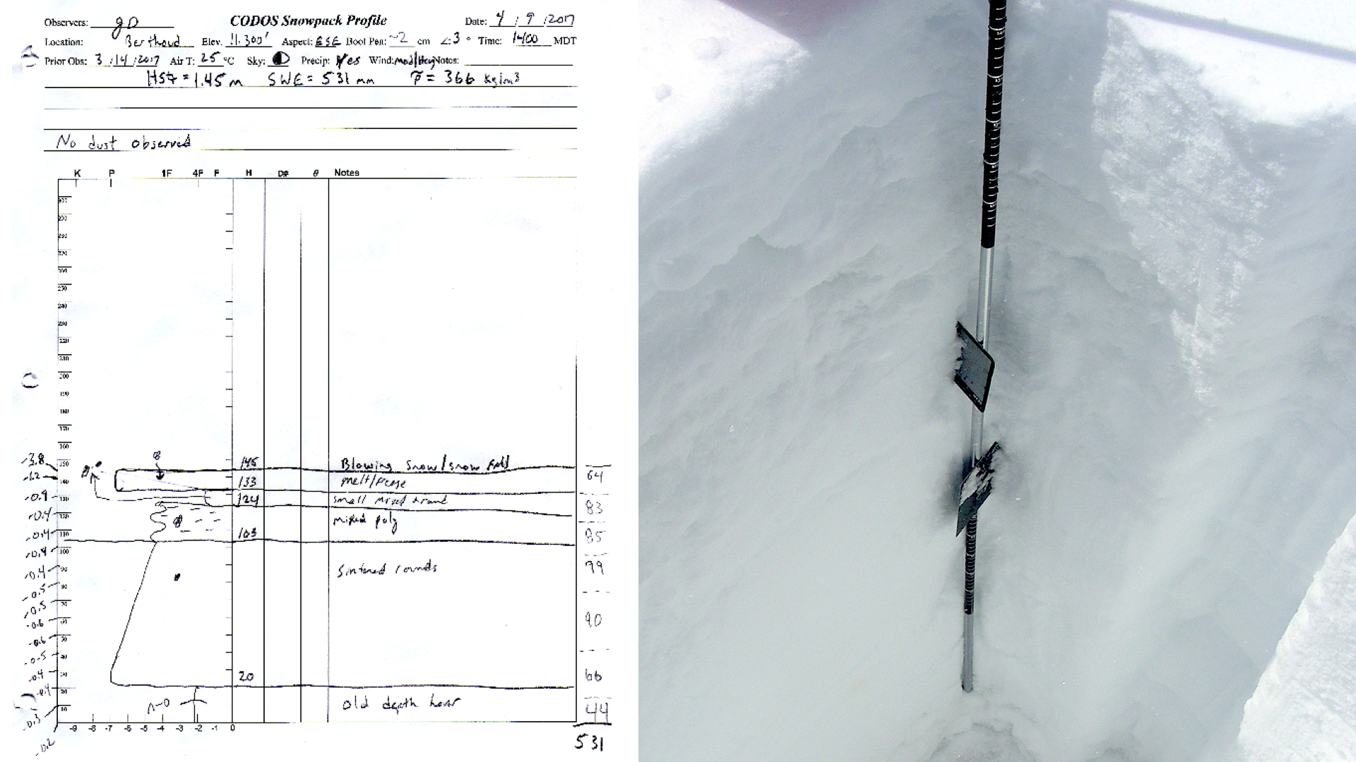
Berthoud Summit – April 9
The CODOS snow profiles indicate SWE increased slightly from 19.8” to 20.9” between the March 14 and April 9 visit. Similar to Loveland Pass, the snowpack is slightly below 0 C°. No dust was observed on the April 9 visit that took place approximately at 10 am, so it is likely Berthoud avoided D4.
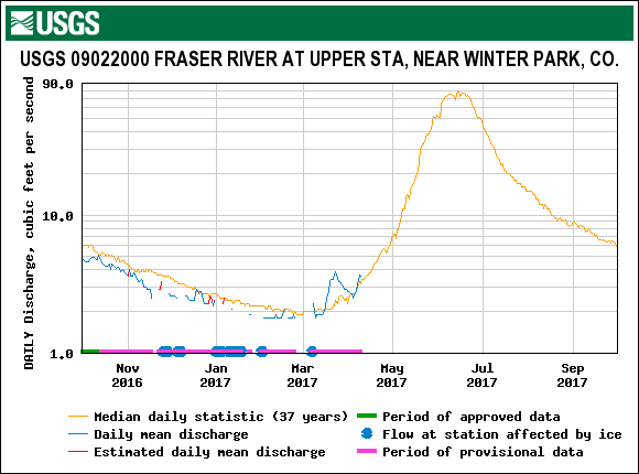
The Fraser River River near Winter Park gauge responded, to a lesser degree than many gauges in southern Colorado, to the warming period in mid-March, and it currently reporting near median discharge.
The Berthoud CODOS site is classified as “High” March 1 SWE, “Min” dust and “Dry” spring conditions, to date. The link below contains plausible runoff scenarios. Unfortunately, there are no water years that offers a direct comparison to WY2017.
Berthoud Summit snow profile. No dust observed in profile or surrounding landscape.
Picture taken from Berthoud Summit SNOTEL
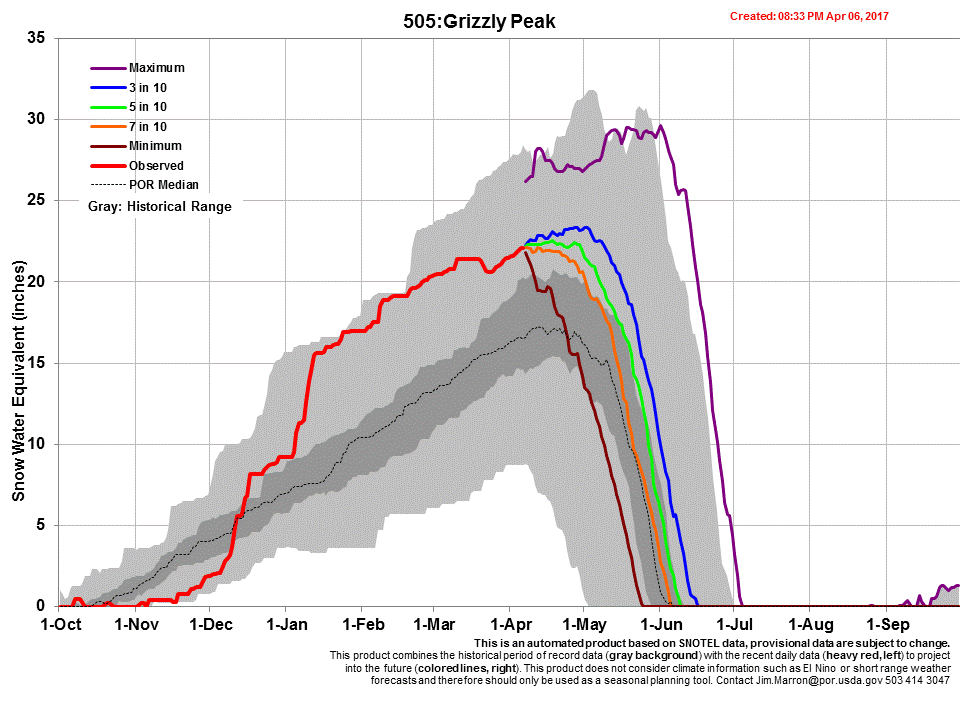
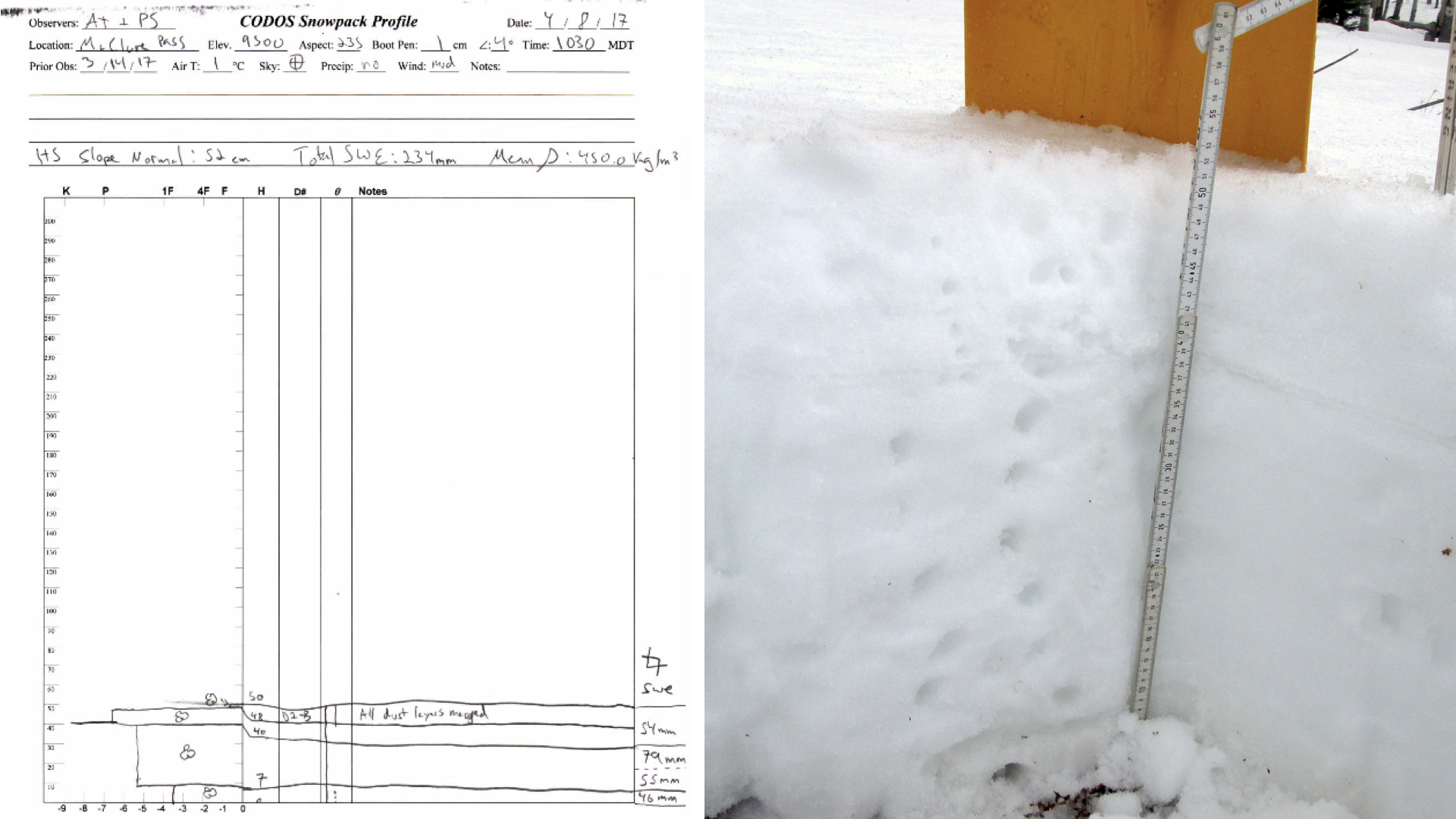
Grizzly Peak/Loveland Pass – April 9
SWE from the snow profile at Grizzly Peak, located near the Grizzly Peak SNOTEL, showed SWE at 23.1”, virtually unchanged from the 23.2” value collected March 14. The top 4” of the snowpack was cool at -3 C° with the rest of the temperature profile being -0.1 C°, just needing a little warm spell to push it to 0 C° throughout. D1/D2 occupies a 3” horizontal space about 4” below the snow surface. The forecasted warm weather due this week will begin to re-expose the merged dust layer which will add to the amount of solar absorption into the snowpack.
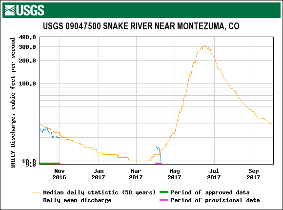
The Snake River near Montezuma gauge is just now starting to report data. We have the Grizzly CODOS site classified as “High” March 1 SWE, “Min” dust and “Dry” spring conditions, to date. The link below contains plausible runoff scenarios based on similar hydrographs under similar conditions. There are no direct comparisons from previous years, but ’07 offers a nearest neighbor comparison.
Grizzly Peak CODOS site, near Grizzly SNOTEL. Merged D1/D2 layers are visible ~4” beneath surface.
Peak near Loveland Pass, picture taken from Grizzly sample site. As of the morning of April 9 dust was not visible on snow surface throughout landscape.
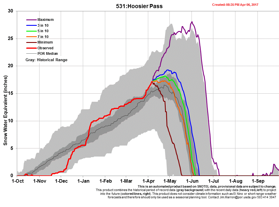
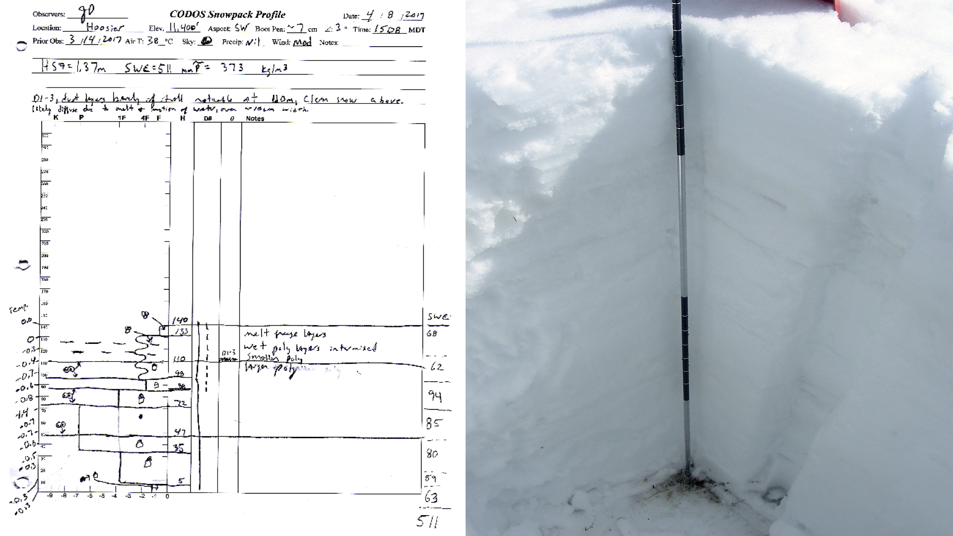
Hoosier Pass – April 8
Snow cover in the Hoosier Pass vicinity has sustained its above median SWE status. Hoosier Pass SNOTEL was 119% of median SWE on March 1st and currently is 109%. CODOS SWE measurements increased from 16” on March 14th to 20.1” on April 8th. Average snowpack temperature is –0.5 C°.
On April 8, the CODOS team observed D1/2 and possibly D3 12” below the snow surface. Taken together, these layers fall under “minimum” dust severity, being faint and will likely not play a significant role in snowmelt rates in the near future (~2 weeks).
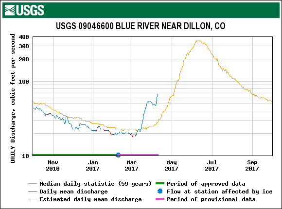
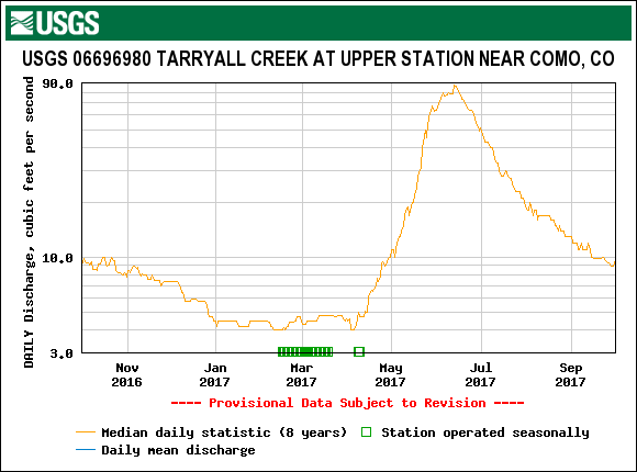
Tarryall Creek stream gauge is currently not operational. Blue River gauge shows near median level base flows during winter and during the mid-March warm-up a surge commenced that is still above median levels.
Using the DERC approach WY2017 at Hoosier Pass has unfolded with “High” March 1st SWE, “Min” Dust intensity, to date, and overall near “Dry” Spring precipitation, so far. In our March 1st Update we posted the following analysis of WY2017 that narrowed the DERC possibilities for Hoosier Pass to prior Water Years with “High” March 1st SWE. 2007 is a close comparison.
The Hoosier Pass snow profile on April 8, 2017. In this photo, light dust events D1-3 are located 1’ below surface
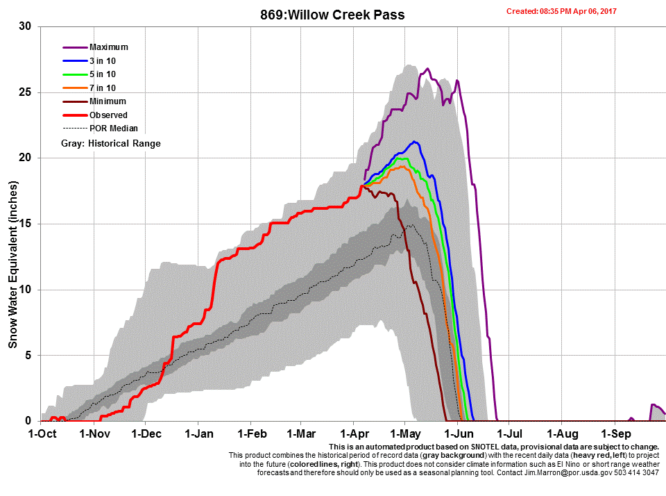
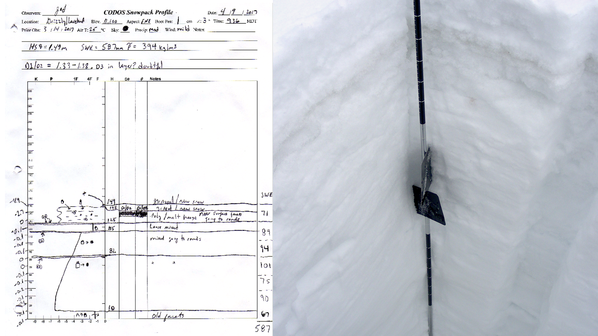
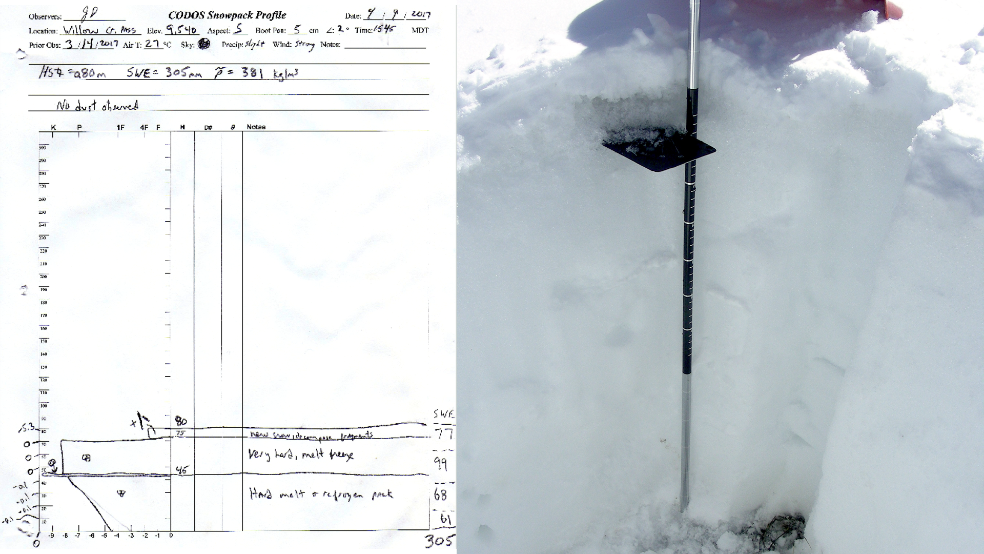
Willow Creek – April 9
Willow Creek, together with Berthoud Summit, has remained dust free so far the WY2017 winter season. The snowpack is close to isothermal and was wetted through it’s full depth and refrozen (composed entirely of large melt forms, or “polycrystals”) from recent cold temperatures stopping further melt. Just a nudge of warmer temperatures are required to reinstate warming and melt. The CODOS profile SWE decreased from 16.9” on March 14 to 12.0” on April 9. Willow Creek Pass SNOTEL is currently at 145% of median. The Upper Colorado River Basin is at 104%.
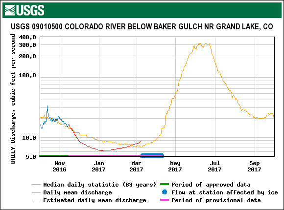
Stream flow is still ice affected at the Baker Gulch near Grand Lake gauge, but main stems of streams are flowing in main tributaries with the upper, contributing streams lesser so with channels mostly snow covered.
Under the DERC approach, WY2017 at Willow Creek Pass has unfolded with “High” March 1st SWE, “Min” Dust intensity and “Dry” spring conditions, to date. In our March 1st Update we posted the following analysis of WY2017 that narrowed the DERC domain for Willow Creek Pass to prior Water Years with High March 1st SWE:
The Willow Creek snow profile on April 9.
Near Willow Creek. Streamflow is greater in lower reaches, and appear primed for ramped up flow in the upper stretches once warmer/sunnier conditions return.
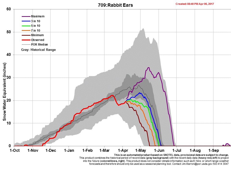
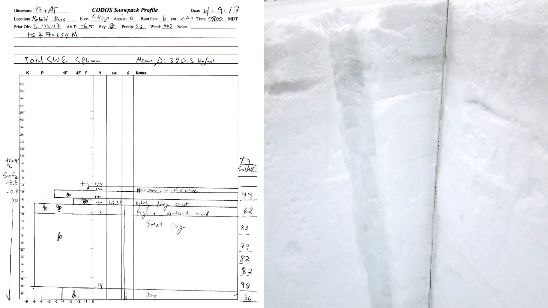
Rabbit Ears Pass – April 9
Rabbit Ears Pass has declined in SWE and snow height since our March CODOS tour and is also now primarily isothermal. Only the snow received the morning of our April 9th visit was showing any notable temperature gradient. The site visit was conducted during the storm that brought D4 to other sites, although no dust was observed from this storm while digging.
Dust was observed in the snowpack, buried under 15cm of snow from early April. This dust is likely D1-3 merged. The dust is highly visible in a lower density layer of melt grains below a thick crust.
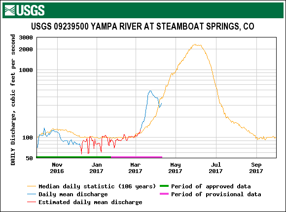
While snowpack has lost height and SWE since mid-March there is still significant water (587mm or 23.1 inches) at the site. This is currently one of our higher SWE sites (along with Wolf Cr. and Red Mountain Pass and Grand Mesa). This year, the Rabbit Ears SNOTEL was our only site showing “Average” March 1st SWE under our DERC Classification framework (all other Sites were “High”), but is showing less dust than our more Southern and Western CODOS sites. Precipitation wise Rabbit Ears is having a “Dry” spring. Yampa River hydrographs for other years with Average March 1st SWE are in the linked slideshow below:
The Rabbit Ears snow profile April 9, 2017. The merged dust layers are visible 5cm below the surface.
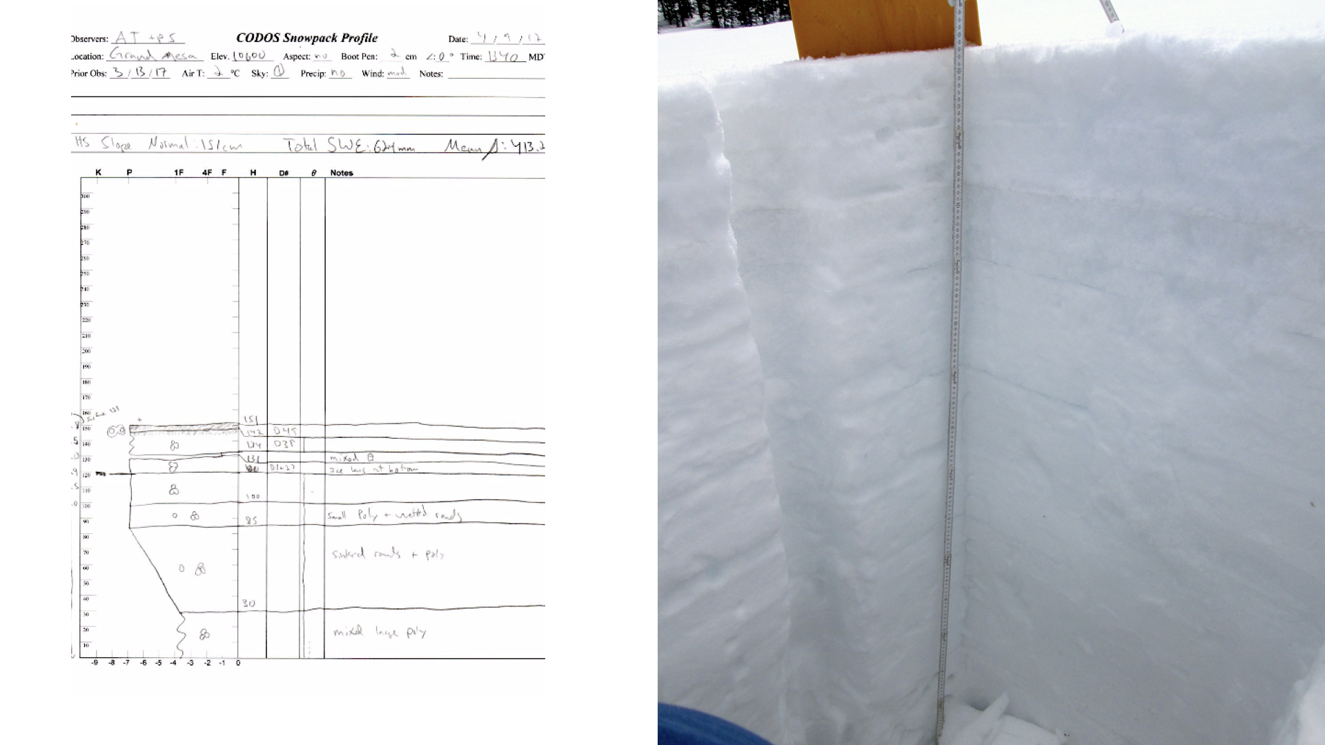
Grand Mesa – April 9
CSAS visited Grand Mesa fresh on the heels of D4, which seemed to have arrived overnight and that morning. We found fresh dust blown into ski tracks and other depressions in the snow surface. Dust here also seemed to have been deposited with some light snow, making this a mixed wet and dry event at this location.
Grand Mesa had slight losses in snow height but gains in SWE, growing to 624mm (24.6 inches), indicating consolidation of new and existing snow. The snowpack is now nearly isothermal, and this type of consolidation is typical for snowpack moving into its springtime regime.
Although originally diffuse and hard to see, all four of this seasons dust events have now been observed at Grand Mesa. With four observed dust events this site is solidly within our “Average” dust realm in the DERC model. March 1st SWE was classified at “High” and so far the site is experiencing “Dry” spring precipitation. Links to Plateau and Surface Creek below contain DERC slideshows for downstream runoff in other “High” March 1st SWE years.
Grande Mesa Watersheds (pdf)
Grand Mesa snow profile on April 9. While Hard to Discern in this photo, D1+2 are merged 30cm below the surface and D3+4 are nearly merged at the surface.
D4 visible blown into old ski tracks. This sort of dust pooling is typical of dry deposition. D4 appeared to be a mixed dry and wet event at Grand Mesa
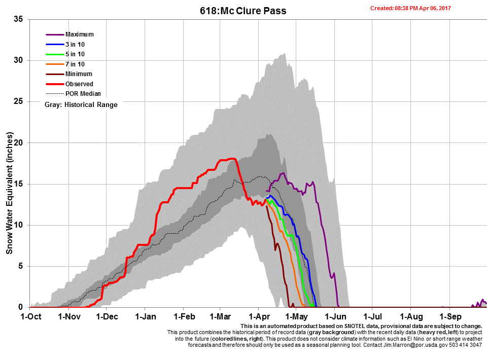
McClure Pass – April 8
Our last CODOS visit to McClure Pass revealed springtime conditions and isothermal snowpack. Since then, snowpack at the site has continued to move though its spring phases, remaining isothermal and losing significant height and SWE. Declines in snowpack and SWE from our last visit have been 35% and 25% respectively. Only 50cm (19.7 inches) of moist to very moist snowdepth remains at the site, with 234mm (9.2 inches) of SWE.
Just as during our last CODOS tour, McClure is further along in it’s spring melt phase than other CODOS sites statewide. While the site was visited before a possible D4 event, D1-3 are merged at the surface, suggesting accelerated melt is underway and can be expected with the forecast clear and warm weather.
Although now rapidly melting, McClure Pass was soundly in our “High” March 1 SWE classification under our DERC framework this year. Current dust is in the “Average” range and the site is experiencing “Dry” spring precipitation. The three DERC slideshows linked below are from downstream waterways and contain hydrographs from other years with “High” March 1st SWE.
Meager Snowpack remains at the McClure Pass CODOS site.
Not far below McClure Pass the surrounding landscape is nearly or entirely snow free
Weather & Climatology
As of this writing, the National Weather Service reports that over the next week a Pacific trough will move inland encouraging southwesterly flow and warm advection. Thursday is forecasted to be the warmest day this week (estimated 10°F above normal). No big storm events are expected over the next 10-days. The Climate Prediction Center’s 6-10 outlook forecasts odds favoring above normal air temperatures and below normal chance of precipitation. The 1-month outlook is similar but less committed as far as air temperatures are concerned. Predicting precipitation a month out is difficult to say the least, and that forecast is showing equal chance.
After a very wet winter, soil moisture in the dust source area is still above median percentile ranking for this time based on a 30-year average. The region is seeing significant drying, which is expected to continue through the upcoming period of warm sunny weather. Over the course of the spring so far soils in the Four Corners dust source region have lost about 20% of their moisture as compared to their capacity for liquid water in the top 5’. This drying is not unprecedented, but the rate is a bit above average for this time of year. Dry soils in the adjacent desert mean increased potential for dust availability for transport to the mountain snowpack, so we will be watching drying (or wetting) trends closely as we move forward through our dust season.