
SUMMARY
March 2015 began with a significant winter storm but continued and ended with very scant subsequent precipitation over most of the Colorado mountain system. Consequently, during March, snowpacks saw either no net gain or declined, some quite substantially. March also produced no dust-on-snow deposition events for Colorado, the result of either an absence of sufficient winds over the Colorado Plateau when soils were available in mid- and late-March, or the unavailability of loose soil during the strong winds associated with the major winter storm at the beginning of March. Colorado entered April with the first dust-on-snow event of the season, warm and significantly sub-par snowpacks, snowmelt underway, and predictions of continued drought conditions for much of the mountain system and for the Colorado Plateau.
LACK OF MARCH PRECIPITATION
March 2015 was the poorest producer of March precipitation in the 12 year period of record at the Swamp Angel Study Plot (SASP) in Senator Beck Basin, at Red Mountain Pass. (Daily precipitation at SASP is represented, in mm units, as the blue bars in the Water Year charts below). Only 7 days during the month produced any precipitation (1 mm or more), and the first two days produced 50 mm (75%) of the 67 mm (2.64”) of total precipitation for the month. Average precipitation for March 2004-2014 was 106 mm (4.17”). Last year, March 2014 produced 105 mm. March 2006 was our largest ever, at 211 mm (8.3”). While these March 2015 values are specific to Senator Beck Basin, they are symptomatic of the dry conditions statewide.
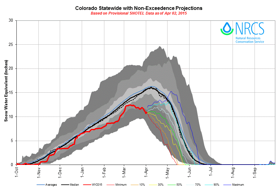
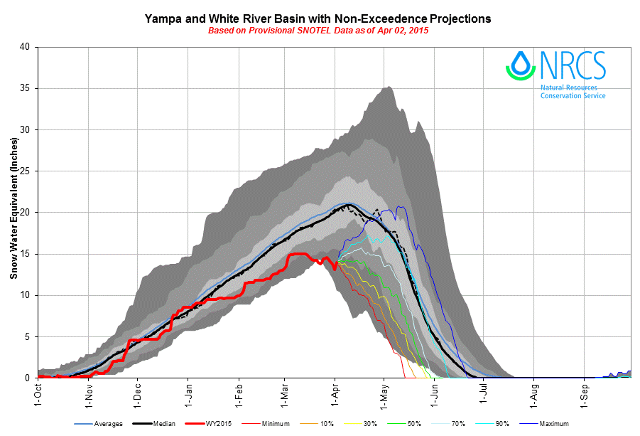
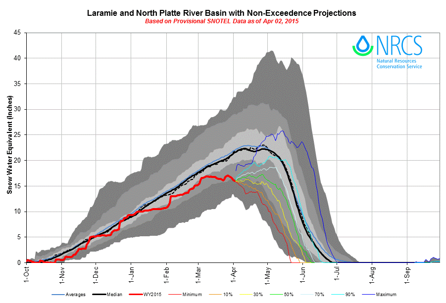
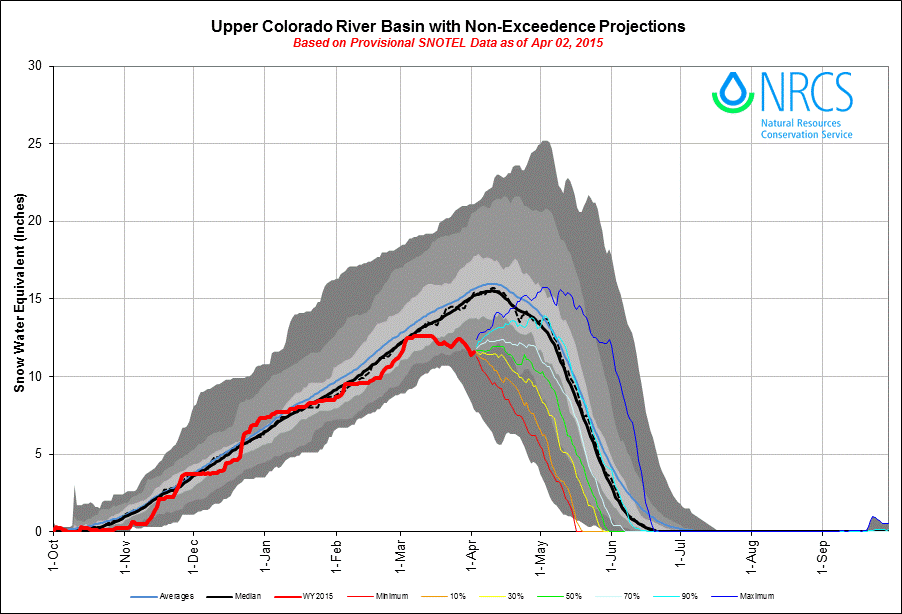
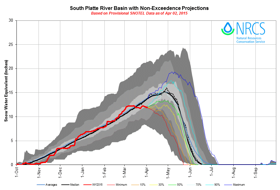
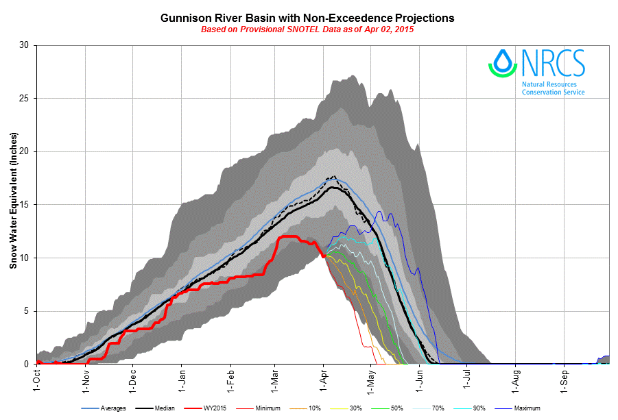
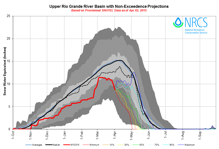
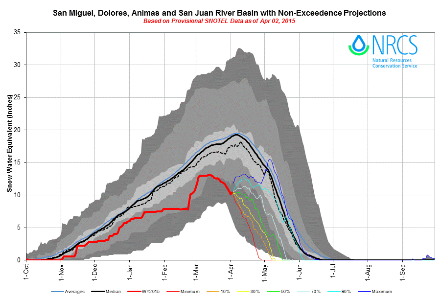
The lack of March 2015 precipitation resulted in either ‘flat’ or declining snowpacks, statewide, during March, as seen in the plots of aggregated Snotel SWE data below, Statewide and by watershed.
LACK OF MARCH DUST-ON-SNOW
March 2015 produced no dust-on-snow deposition events at the Colorado Dust-on-Snow (CODOS) program Senator Beck Basin sentry site. As discussed in prior Updates, this lack of dust events seems to be explained by either the unavailability of loose soils in the Colorado Plateau, due to wetting or snowcover (as in early March), or by the absence of sufficient winds when soils had dried and were available later in March.
Following the wet and very windy winter storm of March 1-2 (CSAS Storm #10), the lack of stormy weather discussed above resulted in the least windy March in our period of record at our Putney Study Plot (PTSP) in Senator Beck Basin. The table below shows monthly “miles of wind” (MOW) passing through the wind instrument at that site, and the graph plots those data, by month. Overall, the winter of 2014/2015 logged the lowest total miles of wind as of the end of March during the period of record at PTSP.
Wind direction is also an important determinant for dust-on-snow events. The wind rose plots below show the distribution of hourly average wind speed and direction for three seasons, as shares of the total of 744 hours in March. March 2014 produced three dust-on-snow events from winds very similar to those of March 2015. The difference in dust production can be attributed to differences in dust availability in the source areas. A wind rose for March 2010 is shown since that month produced (only) 1 dust event, on March 30, within the same SSW vector showing winds >45 mph, in black, as in the March 2015 wind rose. (Note the scale shift in the concentric rings of the 2010 wind rose).
UNFOLDING WY 2015 DUST ENHANCED RUNOFF CLASSIFICATION
In our January 21 Update, CODOS introduced a Dust Enhanced Runoff Classification approach to associating WY 2006-2014 snowmelt runoff behavior at stream gauges with snowpack, dust, and spring weather conditions during those years. Each CODOS site’s webpage begins with a Dust Enhanced Runoff Classification (DERC) discussion where the conceptual Dust Enhanced Runoff Space is presented, modeling the interaction of March 1 SWE, spring dust conditions, and spring weather as the principal factors governing dust effects on snowmelt runoff behavior. A link is shown in that section for a complete DERC analysis for the WY 2006-2014 period for the CODOS site’s adjacent watershed(s), showing the DERC analysis for that watershed and all hydrographs for that period.
In our March 1 Update, all CODOS monitoring sites (and some nearby sites), except Hoosier Pass, were characterized to have either Low or Average snowpacks (SWE) as of March 1, 2015; Hoosier Pass was classified as High. This classification within the Dust Enhanced Runoff Space identified prior water years with similar March 1 SWE conditions, for 18 watersheds, and presented the corresponding hydrographs at CODOS-monitored stream gauging stations in those watersheds. Links to those watershed-specific, March 1 analyses are repeated here:
Given the 9-year period of record of CODOS (WY 2006-2014), not all 27 cells within the 3x3x3 DERC matrix are populated by a Water Year exhibiting each combination of March 1 SWE, dust conditions, and spring weather (precipitation) behaviors, at a given CODOS site. As it happened, March 2015 was completely and uniquely dust-free, with no prior precedent in the CODOS record. As a result, WY 2007 (only) remains as the closest ‘nearest neighbor’ case in the 2006-2014 period, classified with “Min+” dust conditions.
Poor precipitation during March 2015 has further narrowed the relevant March 1 SWE domain identified in our March 1 Update analyses (as presented in the links above) to the “Dry Spring” cell within that March 1 SWE domain, at a given CODOS site, for which there may be no prior WY precedent. Further, the comparatively early warming of the snowcover (see the March 23 Update), and early onset of runoff in the absence of radiative forcing by dust, statewide, still further defines March 2015 as a ‘new’ case study unto itself, not previously captured by the DERC over the WY 2006-2014 period.
Now, with warm (isothermal) snow and snowmelt runoff already underway, and with the advent of our first D1-WY2015 dust-on-snow event at Senator Beck Basin and likely at other CODOS sites and locales, we are unfortunately entering perhaps more familiar terrain with actual “Min Dust”, and with the majority of the Mar/Apr/May dust season remaining. Event D1 was a “dry” dust event, adding no additional snow or SWE to our snowpack. Recent weather on the Front Range and in the northern mountains has added some small quantity to snowcover at CODOS site in those locales but, in the absence of a much wetter April, many Snotels may have experienced Peak SWE already, and this recent snow has fallen on the ‘descending limb’ of the SWE plots at those sites (all CODOS site webpages SWE plots and hydrographs were updated April 2nd). Nonetheless, post-Peak SWE snowfalls do contribute to total snowmelt runoff yields.
WEATHER AND CLIMATOLOGY FORECASTS
As of this writing Sunday, April 5, 2015 the National Weather Service Grand Junction office anticipates dry, windy, and warm conditions early this week for most Colorado mountains, with elevated fire weather concerns. A chance for cooler and perhaps wetter weather arrives mid-week.
In the longer term, on April 4 NOAA’s Climate Prediction Center issued the following 6-10 day outlooks for April 10-14 precipitation and temperatures. As of their 10:21 AM discussion product, Sunday, April 5, NWS-Grand Junction did note model indications of another weather system entering the Great Basin over the same period, but that weather could occur and still fall short of ‘average’ precipitation for this April 10-14 period.
For the entire month of April, CPC has issued the following precipitation and temperature outlook products showing “equal chances” of above- or below-normal conditions for the Colorado mountains:
CPC’s most recent three-month outlook, issued March 15, showed improved chances for Apr/May/Jun precipitation for Colorado, especially the San Juan Mountains.
However, CPC’s April 2015 Drought Outlook, issued March 31, expects persisting or intensifying drought conditions for western Colorado, the Rio Grande headwaters, and the Colorado Plateau.
Overall, these forecasts portend a continuation of “Dry Spring” weather, in the DERC scheme, and little chance of a decline in dust availability on Colorado Plateau source areas. It should be noted that, as seen in the Dust Log above, a high proportion of WY2006-2014 dust events were deposited “dry”, without any accompanying precipitation, and these CPC forecasts do not preclude that behavior.
UPCOMING FIELDWORK
The CODOS team will conduct our next complete circuit of all CODOS sites and those locales during the week of April 13-17, weather permitting. The presence or absence of dust layer D1, and any intervening additional dust-on-snow events, will be determined in full-depth snow profiles, along with collecting our standard snowpack observations.