
Summary
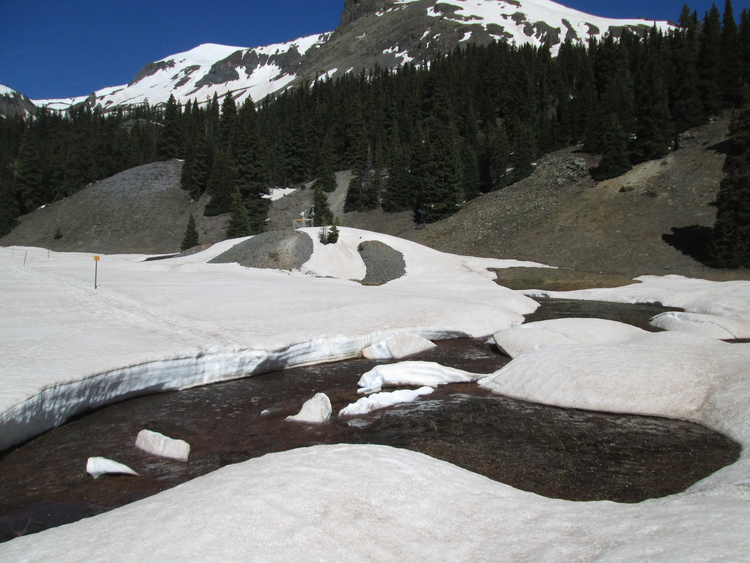
Greetings from Silverton, the Center for Snow and Avalanche Studies, and your Colorado Dust-on-Snow program. CSAS is grateful to our many CODOS program funders for their ongoing, stakeholder support of this applied science effort. Our goal is to assist the greater Colorado water management community as you cope with dust-on-snow impacts on Colorado snowmelt processes. This year we will refine our approach to describing patterns in dust enhanced snowmelt behaviors by focusing on three critical, interacting factors governing the impacts of dust. The first one-third of Winter 2014/2015 has, once again, begun to establish significant divergence in snowpack conditions across the state, favoring the northern mountains. Overall, however, the state Snotel system has recently fallen below 1981-2010 mean and median snowpack values for mid-January. So far this winter we have observed no dust-on-snow deposition events at our Senator Beck Basin Study Area at Red Mountain Pass, the primary ‘sentry site’ for dust-on-snow in Colorado and for CODOS.
Dust-on-Snow Impacts on Colorado Hydrographs 2006-2014
In our WY 2014 Summary report, and in presentations during Fall 2014, we introduced a refined approach to understanding the impacts of dust-on-snow on Colorado snowmelt runoff ‘patterns’, as reflected in headwater hydrographs. CODOS has observed dust conditions and snowmelt behaviors in Colorado since 2006. It has become apparent, in that period, that the interactions of three primary factors – March 1 SWE, spring dust intensity, and spring weather (precipitation) – comprise a “dust enhanced snowmelt runoff space” (Figure 1). First and foremost among those factors, snowcover water content (i.e., snow water equivalence, or SWE) in Colorado watersheds dictates snowmelt runoff yields and a basin hydrograph’s overall magnitude. March 1 SWE conditions offer a meaningful benchmark in seasonal snowpack formation that also coincides with the onset of ‘dust season’, as 80% of the dust-on-snow events observed by CODOS since 2005 have occurred in March, April and May.
Then, although the presence of dark mineral dust at or near the snowcover surface during daytime always accelerates snowmelt rates by reducing snow albedo and increasing absorption of solar radiation, dust-on-snow does not automatically result in an early runoff cycle. Considerable variation in the overall timing and rates of snowmelt from equivalent snowpacks containing equivalent dust can occur as a result of differences in the number and size of March, April, and May snowfalls. A dry spring, with fewer and smaller spring snowfalls, prolongs dust layer exposure and maximizes dust impacts on snowmelt. A wet spring with frequent, large snowfalls results in repeatedly burying exposed dust and restoring high snow albedo, delaying the full impact of dust until a later period of prolonged dust emergence. Hence, besides contributing additional snow to the seasonal total, March, April and May precipitation plays a key role in determining the timing and rate of dust-enhanced snowmelt runoff, from a given snowpack containing dust.
CODOS has now observed nine seasons of dust-enhanced snowmelt runoff behavior throughout the Colorado mountains (WY 2006-2014). Hydrographs at headwater stream gauges have been evaluated and classified within the framework of this dust enhanced snowmelt runoff space utilizing a 3 x 3 x 3 cell matrix corresponding to general characterizations of SWE, dust intensity, and spring weather, as shown in Figure 1.
Figure 1: a conceptual dust enhanced snowmelt runoff model integrating the interactions of March 1 SWE, dust intensity, and spring precipitation.
In this approach, March 1 SWE classifications are based on NRCS 1981-2010 statistics for Snotel stations proximal to the eleven sites monitored by CODOS. “Average SWE” is defined as a Snotel site’s 1981-2010 median value for March 1, +/- 10%. Values outside that 90-110% of median condition are classified as either High or Low March 1 SWE.
Dust intensity classification is based on dust conditions observed since 2005 at CSAS’s Senator Beck Basin Study Area (SBB). Dust intensity characterization at SBB represents a difficult challenge since dust deposition intensity has, overall, increased during the period of CODOS observations. As such, the notion of “average” dust intensity has changed over that period and may not yet have stabilized. During the past four seasons, in collaboration with USGS, CODOS has collected and analyzed dust mass loading samples and quantified dust loading at SBB. Those measurements have enabled calibration, from snowpit observations and photographs, of prior seasons at SBB using this three-part classification scheme.
Although still a short period of record, during a period of rapidly changing conditions, these characterizations may be sufficient to distinguish one season from another in this three-part classification scheme. Within this period of record (2006-2014) Water Year 2007 is classified as “Min+” dust intensity and WY 2006 and WY 2010 are considered “Max-“. (Prior WY’s 2004 and 2005 might also be classified as “Min” dust seasons at SBB, relative to subsequent years, but are not included in these analyses due to incomplete observations.) It is further understood that dust intensity at SBB is typically stronger than observed at sites farther downwind, to the north and east. (CODOS resources have not enabled the collection of dust mass loading samples comparable in quality and frequency to those collected at SBB.) Dust intensity characterizations at sites beyond SBB are, in this classification, both tied to “Min”, “Avg”, and “Max” conditions at SBB as well as being site specific and relative to observed “all layers merged” intensity near the end of the season at the given site (i.e., of generally lower ‘absolute’ intensity than SBB).
Spring precipitation classifications are also based on NRCS 1981-2010 statistics for Snotel stations proximal to the eleven sites monitored by CODOS. Average precipitation is defined as a Snotel site’s 1981-2010 median total of March, April, and May measured precipitation, +/- 15%. Values outside that 85-115% of median condition are classified either Wet or Dry. This more generous range in Average precipitation values is utilized in order to capture the larger spatial variation in spring precipitation from convective sources. Given the generally high elevations of these Snotel sites, March, April, and May precipitation is assumed to be snow and no parsing of rain precipitation was attempted. Analyses of annual variances in total March/April/May precipitation since 2006 have been performed and are now posted on all CODOS site webpages.
Using these rules and procedures, the following table classifies WY 2014 conditions at 19 headwater stream gauges associated with the eleven CODOS monitoring sites (including Senator Beck Basin) and associated Snotels that CODOS monitors:
All other Water Years have been similarly classified. An Excel workbook containing those data is also posted at the CODOS program home page in the Dust Enhanced Runoff Classification discussion. Also, similar classifications were performed for each of the headwater stream gauges, by Water Year. That Excel workbook (Runoff_Space_by_Watershed.xlsx) is also available at the CODOS program home page in the Dust Enhanced Runoff Classification discussion. Finally, links to presentations of these individual stream gauge classification matrices, and to the 2006-2014 hydrographs from that location, are posted on the website for each CODOS site, under their Dust Enhanced Runoff Classification discussion.
Current Conditions & Forecasts
Dust Events
As of this writing, CODOS has logged no dust-on-snow events so far in WY 2015. This absence of dust-on-snow, to-date, is not particularly unusual, as seen in the chart below documenting the low frequency of fall and early winter dust events since 2005. Additional Dust Log information is posted on the CODOS program home page at http://www.codos.org/#log.
Snowpack Conditions
Current snowpack conditions averaged across all Snotels in the State recently fell below the 1981-2010 mean and median. As of January 15, 2015 some watersheds possess more robust snowcover than others, with the southern mountains experiencing significantly below-average snowpack formation to-date.
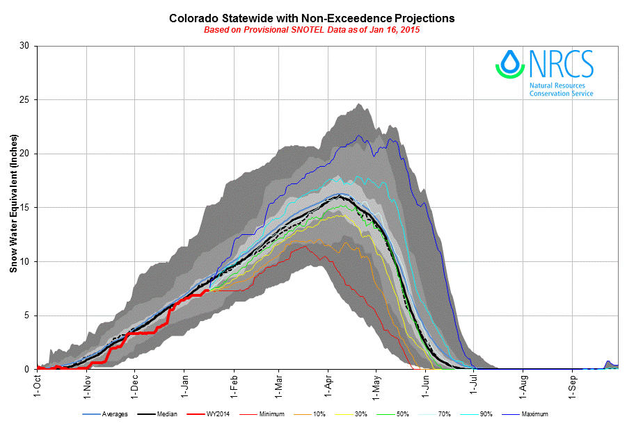
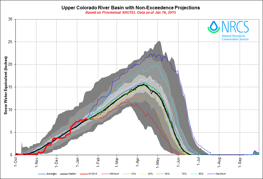
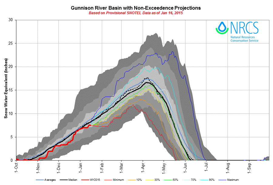
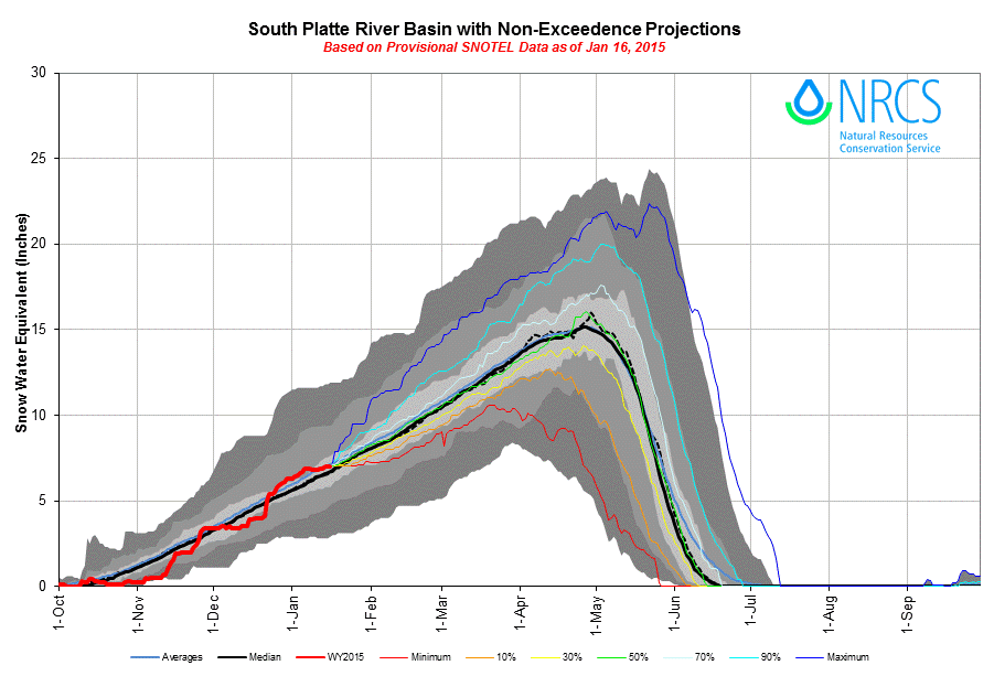
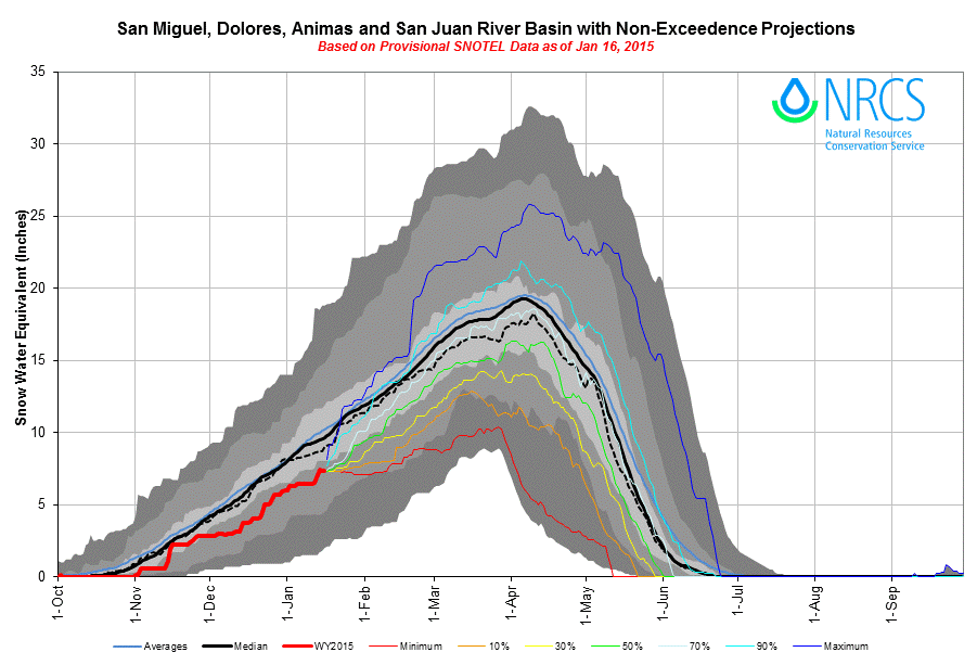
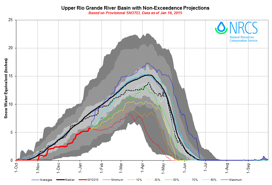
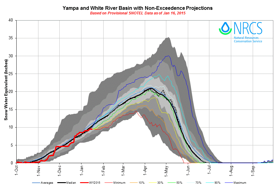
(click on the plots above to view a larger image)
Based on historical data, these NRCS plots include non-exceedence projections for future snowpack development. At the all-Snotels-aggregated, state-wide scale, NRCS indicates a 70% probability of non-exceedance of near-median (or better) snowpack developing during the remainder of the winter. At the watershed scale, and given current conditions, odds are projected as near-even (50% non-exceedence probability) for the Upper Colorado River Basin and the South Platte River Basin to still develop a near-normal snowpack. Faring worst of all, NRCS indicates a 90% probability of non-exceedance that a near-median snowpack (or better) will develop in the Upper Rio Grande River Basin during the remainder of the winter. Or, put another way, given current snowpack conditions it would be very unusual for the Upper Rio Grande River Basin to develop a near-normal snowpack this Water Year. Using these NRCS projections, these are the non-exceedence probabilities of recording median SWE conditions in these six basins on March 1, 2015:
Climatological Outlooks
The National Weather Service Climate Prediction Center (CPC) has issued climatological outlooks for February temperatures and precipitation, and also for March/April/May weather. In February, although western Colorado may be somewhat warmer than normal, the Southern Mountains and portions of the Central Mountains and Front Range show a slightly better-than-even chance of above-average precipitation, perhaps nudging snowpacks closer to normal by March 1.
Farther out, outlooks for March/April/May temperature and precipitation (shown below) show no probable variance from normal temperatures for Colorado but significant probabilities of above-average precipitation, particularly over the southern half of the state. This precipitation outlook may foreshadow a “wet” spring for the Colorado mountains, under the classification scheme of the dust-enhanced snowmelt runoff model discussed above.
Application of the Dust Enhanced Snowmelt Runoff Model
By evaluating and classifying the many combinations of March 1 snowpack, dust-on-snow intensity, and spring precipitation conditions observed across the state since 2006, and monitoring those conditions as they evolve this winter and spring, CODOS will seek prior similar scenarios that narrow the range of plausible (and perhaps probable) spring 2015 snowmelt runoff behaviors, as shown in past hydrograph patterns. CODOS has compiled these past-year datasets by watersheds, by Water Years, and by regions. As described above, those new analyses have been posted to CODOS site webpages and to the CODOS program home page for your use and for citation in future Updates.
It is our hope, of course, that using our past CODOS experience and current-year observations can provide insight, through an iterative process, into potential variations (or an absence of variation) from the median hydrograph pattern at a given stream gauge. As always, our ability to recognize and/or predict unfolding snowmelt behavior patterns may be confounded by unexpected spring weather and related dust-on-snow events. We may see weather and/or dust events that substantially shift conditions from one ‘dust- enhanced runoff space’ to another ‘space’ and require major revision ‘on the fly’. Clearly, CODOS must continue to rely on National Weather Service expertise in weather (including wind) forecasting and, like you, we will have to roll with any unexpected punches.
For our part, CSAS has begun exploring our own dataset of winter storms at Senator Beck Basin, tracking the number of storms, or “weather opportunities”, observed since we established the study area in the winter of 2003/2004. Within that short period of record, CSAS has logged an average of 25.5 winter storms (containing at least 0.5” water content) per season, ranging from a low of 20 storms in winter 2004/2005 to a high of 33 storms in the winter and endless spring of 2010/2011. A detailed breakdown of logged Senator Beck Basin storms and precipitation is posted at our Winter Storms Data webpage, at http://www.snowstudies.org/storms.html. So far during winter 2014/2015 we have logged only 6 storms, well short of the average of the 11-year average of 10 storms by the end of January. Over (only) 11 winters, Senator Beck Basin has logged an average of 3.2 storms in March, 4.1 storms in April, and another 2.0 storms in May. These numbers mask the considerable variability of our spring weather – March, April and May of 2011 produced 15 winter storms, and an additional storm in June, for instance. Nonetheless, it is possible that we have begun to see a central tendency in these data, given that Water Year 2011 (35 storms) and Water Year 2012 (23 storms) very nearly captured the full range of inter-annual variation exhibited in the nearby Red Mountain Pass Snotel dataset. CSAS is discussing this storm counting approach and sharing our data with staff at NWS Grand Junction, the State Climatologist, and with NCAR Hydrometeorological Applications researchers.
In the hydrologic realm, CSAS resources, at present, do not enable us to develop in-house streamflow forecasting capabilities. CODOS will not attempt to provide revised streamflow forecasts at the stream gauges we’re monitoring. The NOAA Colorado Basin River Forecast Center will remain your best source for those quantified forecasts. CBRFC does receive all CODOS Update and Alert products as they are issued and has begun utilizing those to amend their forecasts to reflect dust effects anticipated by CODOS.
CODOS products, rather than predicting precisely quantified flows or yields, will focus on anticipated or actually occurring significant pattern deviations from the median shape of a stream gauge’s hydrograph, as the three factors represented in the dust-enhanced snowmelt runoff model develop and play out. WY 2015 will be our first season attempting to apply this pattern-based approach – we hope it will be useful and will look forward to evaluating the effort, with you, next summer.
Barring any earlier developments of interest, our next Update in late February will focus on the current status of Colorado watershed snowcover conditions, dust conditions, and on updated Colorado climatological outlooks as we approach March 1, seeking to narrow the ‘space’ within which spring 2015 could plausibly play out and identifying similar prior years. Naturally, we will issue Dust Alerts as dust events occur.
Looking forward to seeing many of you at the upcoming Colorado Water Congress in Denver ...