.author-name { display: none; }
CODOS Update: D3 Emerging, Dust Event #4, Warm-up thru Thursday then more Precip

CODOS Update: D3 Emerging, Dust Event #4, Warm-up thru Thursday then more Precip

Dust Free So Far and Healthy Snowpack

Greetings From Silverton, 

Despite a dry and lackadaisical start to winter, persistent snowcover in Senator Beck occurred on November 21, we have seen a major turn-around with a steady stream of productive storms.  We have received eight winter storms so far (Storm #8 Report will follow shortly) that in and of themselves have totaled ~10.0" of water.  Snow depth at Swamp Angel is at 4.5’ and the wind effected Senator Beck site is lingering around 1.5’.

CODOS Tour Update: Dust Present Throughout State, On Top Of Very Big Snowpack

CODOS Tour Update: Dust Present Throughout State, On Top Of Very Big Snowpack

Dust Free So Far and Healthy Snowpack

Greetings From Silverton, 

Despite a dry and lackadaisical start to winter, persistent snowcover in Senator Beck occurred on November 21, we have seen a major turn-around with a steady stream of productive storms.  We have received eight winter storms so far (Storm #8 Report will follow shortly) that in and of themselves have totaled ~10.0" of water.  Snow depth at Swamp Angel is at 4.5’ and the wind effected Senator Beck site is lingering around 1.5’.

CODOS Update: Significant Dust, Precip in Forecast, Warm-Up this Weekend

CODOS Update: Significant Dust, Precip in Forecast, Warm-Up this Weekend

Dust Free So Far and Healthy Snowpack

Greetings From Silverton, 

Despite a dry and lackadaisical start to winter, persistent snowcover in Senator Beck occurred on November 21, we have seen a major turn-around with a steady stream of productive storms.  We have received eight winter storms so far (Storm #8 Report will follow shortly) that in and of themselves have totaled ~10.0" of water.  Snow depth at Swamp Angel is at 4.5’ and the wind effected Senator Beck site is lingering around 1.5’.

CODOS Update: Data Plots and General Observations

CODOS Update: Data Plots and General Observations

Dust Free So Far and Healthy Snowpack

Greetings From Silverton, 

Despite a dry and lackadaisical start to winter, persistent snowcover in Senator Beck occurred on November 21, we have seen a major turn-around with a steady stream of productive storms.  We have received eight winter storms so far (Storm #8 Report will follow shortly) that in and of themselves have totaled ~10.0" of water.  Snow depth at Swamp Angel is at 4.5’ and the wind effected Senator Beck site is lingering around 1.5’.

CODOS Update: Dust Event #3 Observed

CODOS Update: Dust Event #3 Observed

Dust Free So Far and Healthy Snowpack

Greetings From Silverton, 

Despite a dry and lackadaisical start to winter, persistent snowcover in Senator Beck occurred on November 21, we have seen a major turn-around with a steady stream of productive storms.  We have received eight winter storms so far (Storm #8 Report will follow shortly) that in and of themselves have totaled ~10.0" of water.  Snow depth at Swamp Angel is at 4.5’ and the wind effected Senator Beck site is lingering around 1.5’.

CODOS Update: Live Graphics Page, DERC and Radiation Plots

CODOS Update: Live Graphics Page, DERC and Radiation Plots

Dust Free So Far and Healthy Snowpack

Greetings From Silverton, 

Despite a dry and lackadaisical start to winter, persistent snowcover in Senator Beck occurred on November 21, we have seen a major turn-around with a steady stream of productive storms.  We have received eight winter storms so far (Storm #8 Report will follow shortly) that in and of themselves have totaled ~10.0" of water.  Snow depth at Swamp Angel is at 4.5’ and the wind effected Senator Beck site is lingering around 1.5’.

CODOS Update: March 26 SASP and Red Mt Observations

CODOS Update: March 26 SASP and Red Mt Observations

Dust Free So Far and Healthy Snowpack

Greetings From Silverton, 

Despite a dry and lackadaisical start to winter, persistent snowcover in Senator Beck occurred on November 21, we have seen a major turn-around with a steady stream of productive storms.  We have received eight winter storms so far (Storm #8 Report will follow shortly) that in and of themselves have totaled ~10.0" of water.  Snow depth at Swamp Angel is at 4.5’ and the wind effected Senator Beck site is lingering around 1.5’.

CODOS Update: March CODOS Tour Report

CODOS Update: March CODOS Tour Report

Dust Free So Far and Healthy Snowpack

Greetings From Silverton, 

Despite a dry and lackadaisical start to winter, persistent snowcover in Senator Beck occurred on November 21, we have seen a major turn-around with a steady stream of productive storms.  We have received eight winter storms so far (Storm #8 Report will follow shortly) that in and of themselves have totaled ~10.0" of water.  Snow depth at Swamp Angel is at 4.5’ and the wind effected Senator Beck site is lingering around 1.5’.

CODOS Update: D2 Observed, Snow Keeps Coming

CODOS Update: D2 Observed, Snow Keeps Coming

Dust Free So Far and Healthy Snowpack

Greetings From Silverton, 

Despite a dry and lackadaisical start to winter, persistent snowcover in Senator Beck occurred on November 21, we have seen a major turn-around with a steady stream of productive storms.  We have received eight winter storms so far (Storm #8 Report will follow shortly) that in and of themselves have totaled ~10.0" of water.  Snow depth at Swamp Angel is at 4.5’ and the wind effected Senator Beck site is lingering around 1.5’.

CODOS Update: March 1 DERC, Dust and SWE Conditions

CODOS Update: March 1 DERC, Dust and SWE Conditions

SUMMARY

Colorado has begun March with “high” conditions completely dominating the range of snowpack conditions among major basins across the Colorado Mountains.   This update summarizes snowpack conditions state-wide and evaluates March 1st snow water equivalent (SWE) data from SNOTEL stations associated with our eleven CODOS sites and places them within the framework of the Dust Enhanced Runoff Classification scheme (DERC) developed by CODOS.  A summary is presented by individual Basin, and provides a site-specific analyses for each CODOS site (linked below). 

CODOS Update: Atmospheric River, Light D1, Current Snowpack Conditions

CODOS Update: Atmospheric River, Light D1, Current Snowpack Conditions

Dust Free So Far and Healthy Snowpack

Greetings From Silverton, 

Despite a dry and lackadaisical start to winter, persistent snowcover in Senator Beck occurred on November 21, we have seen a major turn-around with a steady stream of productive storms.  We have received eight winter storms so far (Storm #8 Report will follow shortly) that in and of themselves have totaled ~10.0" of water.  Snow depth at Swamp Angel is at 4.5’ and the wind effected Senator Beck site is lingering around 1.5’.

CODOS Update: Current Conditions, SNOTEL Plots

CODOS Update: Current Conditions, SNOTEL Plots

Dust Free So Far and Healthy Snowpack

Greetings From Silverton, 

Despite a dry and lackadaisical start to winter, persistent snowcover in Senator Beck occurred on November 21, we have seen a major turn-around with a steady stream of productive storms.  We have received eight winter storms so far (Storm #8 Report will follow shortly) that in and of themselves have totaled ~10.0" of water.  Snow depth at Swamp Angel is at 4.5’ and the wind effected Senator Beck site is lingering around 1.5’.

CODOS Update: Mid-December Current Conditions

CODOS Update: Mid-December Current Conditions

Dust Free So Far and Healthy Snowpack

Greetings From Silverton, 

Despite a dry and lackadaisical start to winter, persistent snowcover in Senator Beck occurred on November 21, we have seen a major turn-around with a steady stream of productive storms.  We have received eight winter storms so far (Storm #8 Report will follow shortly) that in and of themselves have totaled ~10.0" of water.  Snow depth at Swamp Angel is at 4.5’ and the wind effected Senator Beck site is lingering around 1.5’.

CODOS WY2019: Snow School, Nice Start to Water Year 2019

CODOS WY2019: Snow School, Nice Start to Water Year 2019

Greetings from Silverton,

Well good riddance to WY2018.  After Colorado’s warmest and 3rd driest (driest for northwestern and southwestern Colorado) water year on record, it is a relief to begin a new water year accompanied by cooler than normal air temperatures and a nice dose of precipitation in western, eastern Colorado, and some mountain areas.  In the past three weeks we received tropical moisture from hurricane Rosa and Sergio and in addition a productive system out of the north.  In our Senator Beck Study Basin located at Red Mt Pass in the San Juan Mountains, so far this water year we have received 4.6” precipitation and at our higher monitoring site (12,200’) we have 15” of snow accumulation.  The precipitation has slowly started showing itself in our stream gauge.  Hard to imagine streams being in a much worse state, a few weeks ago all stream channels in Senator Beck were dry (and the Animas River at its lowest flows in 107 year record), with only a trickle of water coming to the surface a few hundred feet upstream of our gauge near the outlet of the watershed.  After such a devastating WY2018 we have a long way to go in making up such a large precipitation deficit.  At least the long-term forecast going into WY2019 is calling for a pattern shift from what we experienced last year.  There is a 70-75% chance of El Nino conditions this winter which bodes well for bringing increased precipitation to the southwest.

Storm Reports:  Now that the higher elevations in Senator Beck will likely hold onto the snow accumulated over the last few weeks we will begin issuing our winter storm reports.  If you are not familiar, we issue storm reports following a winter storm in the San Juan Mountains.  Sometimes the reports are just a few sentences and other times we do a detailed analysis on something interesting that happened or is in the forecast.  To be added to our email list and be notified when we have posted a storm report to our website please contact Jeff Derry (jderry@snowstudies.org).  Reports can be viewed here:  https://snowstudies.org/winter-storm-data/

CODOS:  In our Colorado Dust-on-Snow Department we are looking forward to serving the snow and water community for another winter season with dust-on-snow observations and assessments as to the influence of dust on snowmelt timing and rates around Colorado.  If you have a new colleague in your office that would benefit from our CODOS updates please forward along our contact information to add them to our update notification email list.  As a reminder, our updates are posted to our website along with all kinds of other snowpack and streamflow observations and analysis:  http://www.codos.org/#codos

Snow School for Water Professionals:  Once again we are offering Snow School for Water Professionals this year from February 20 - 22, 21018.  This combination classroom and field course will begin on Wednesday morning at our office in Silverton and end on Friday afternoon.  This class is perfect for anyone wanting to learn more about the role of snow and our mountain systems as it pertains to water resources.  Attached is a flyer, please post in your workplace and please do not hesitate to contact me with questions. 

Below are a Few Links to Stay Informed about Snow, Water, and our Mountain Ecosystems:  

Colorado Climate Center: http://climate.colostate.edu/~drought/

H2O Radio: http://h2oradio.org/CurrentStory.html

Water Information Program: https://waterinfo.org/

Water Education Colorado: https://www.watereducationcolorado.org/

Rocky Mt Climate Organization: http://www.rockymountainclimate.org/

Hutchins Water Center, Mesa State: https://www.coloradomesa.edu/water-center/index.html         

More soon.

off01_prcp.gif
off01_temp.gif

WY 2018 Season Summary

WY 2018 Season Summary

SUMMARY

After a worrisome October and November when Colorado received very little precipitation and experienced very warm temperatures, winter finally kicked into action and Colorado started receiving abundant snowfall, building the snowpack rapidly during the months of December, January, and into February.  One of the big stories this winter season is the atmospheric rivers that fueled these productive storms, which were record breaking in some locations.  On the other end of the spectrum, one of the other big stories this winter is the observed warmest March on record.  The effects of this hot month (preceded by a very warm February) was a rapid warming of the snowpack and snowmelt at lower elevations and valleys, resulting in most stream gauges observed a 2-3 week bump in stream flow in mid-March thru the first part of April.  However, Colorado recovered from the hot/dry spell with a long stretch of regular precipitation beginning around March 23 – April 4.  A dry spell was again repeated April 5-19.  And, starting the latter part of April regular precipitation (however sparse) was observed steadily but intermittently until June 1.     

At the Center for Snow and Avalanche Studies’ (CSAS) Senator Beck Basin Study Area (SBB) at Red Mountain Pass, the primary Colorado Dust-on-Snow Program (CODOS) monitoring site, WY2017 produced a total of four separate dust-on-snow events, on the light side of a typical dust loading season based on observations going back to WY2005.  Dust season began relatively late in the season.  With the abundant moisture in the dust source area, the Southern Colorado Plateau, dust mobilization was kept in check until March when soils started drying out.  Dust-on-snow events March 5, 23, 31 and on April 9 were documented.  Surprisingly no dust events were observed the rest of April and May, although a couple haze events were noted.  On June 12 a big dust storm in the desert southwest was observed with the USGS dust cameras, additional dust on any remaining snow in the Colorado Mountains was not observed at lower elevations, but it is possible some higher elevation snow cover could have received additional dust from this event. Of the four documented dust events, two of these events were pretty heavy in their severity.  The end result, even though total mass loading of dust was light, with the location of the dust in the snowpack (i.e. upper portion) and its consequential role in snowmelt, we classified dust severity as “Average”, albeit the lighter side of average at SBB.  Northern and some Central CODOS sample sites in Colorado were classified as “Minimum” dust severity.  The transition from “Average” to “Minimum” severity took place in Central Colorado, thus some Central and all Southern CODOS sites were classified as “Average”.

CODOS Update: Snow Gone at SBSP (12,200')

CODOS Update: Snow Gone at SBSP (12,200')

Greetings from Silverton,

In Senator Beck Basin (SBB), Senator Beck Study Plot (12,200') held onto snow only a week longer than Swamp Angel (11,100').  Not to say snow is completely gone at higher elevations but it has been going fast.  Current snow covered area in the Uncompahgre is around 22% and is 14-28% in the other Southern Colorado, high elevation basins.  Of course some of the Central and Northern basins have a bit more snow cover but these basins are also seeing rapid ablation.  It has been the worst combination of factors this spring; a shallow snowpack, an average to high-end of average dust-on-snow conditions around the state (which has been solidly exposed since May 2), a complete lack of significant spring storms and in it's stead warm/sunny conditions (at SBB we went 16 days in May without recording any precipitation), all has combined to melt the snow early and fast.  With the warm air temperatures evaporative demand is extremely high as well, quickly taking what moisture exists from the soils and plants.  The area around "Swamp" Angel is currently very dry with little of the usual wet soils.  Typically, it is a very interesting time of the season when snow melts out at SNOTEL stations, leaving the majority of snow at higher elevations above ground-based monitoring networks - except for SBB.  And typically when SBSP melts out we see a second surge in the snowmelt hydrograph at Senator Beck stream gauge.  But this year according to our observations higher elevations have acquired an amount of snow relative to lower elevations and does not appear we will see much of a second bump.  

Warmer weather is expected to continue over the next couple weeks and in the mountains there are chances of afternoon thunderstorms, but that is about it.  Please see SWE, streamflow, and SBB plots below.  

More from Silverton soon.

Just to make this plot even more busy, I added Snow Covered Area (%) in the Uncompahgre Basin since this is the watershed that Senator Beck is located, and to show the relationship with Uncompahgre River flows.  Currently, SCA is around 22% bas…

Just to make this plot even more busy, I added Snow Covered Area (%) in the Uncompahgre Basin since this is the watershed that Senator Beck is located, and to show the relationship with Uncompahgre River flows.  Currently, SCA is around 22% based on the SNODAS Decision Support System.  Snow was all gone at SASP by May 16, which is why we see the dive in albedo at that time.  Streamflow is well past its peak in Southern Basins and for a number of Central Basins.

Snow under the depth sensor at Senator Beck Study Plot reported 0" as of 5 pm on May 23.  Senator Beck stream gauge at 11,000' saw its peak discharge on May 17, whereas most gauges in Southern Colorado, being located lower in their basins …

Snow under the depth sensor at Senator Beck Study Plot reported 0" as of 5 pm on May 23.  Senator Beck stream gauge at 11,000' saw its peak discharge on May 17, whereas most gauges in Southern Colorado, being located lower in their basins and thus integrating all the runoff in the watershed, saw peak the prededing week.   

We finally recorded precipitation at SBB over the last four days, but only totaling 8 mm (0.3").  Prior to that we did not see precipitation since May 2.  

We finally recorded precipitation at SBB over the last four days, but only totaling 8 mm (0.3").  Prior to that we did not see precipitation since May 2.  

Ablation rates for a few select SNOTEL stations.  Ablation is faster than normal around Colorado.  Wolf Creek melted out over 5 weeks early.  Rabbit Ears is on track to melt out about 7-10 days early.  Red Mt SNOTEL melted about …

Ablation rates for a few select SNOTEL stations.  Ablation is faster than normal around Colorado.  Wolf Creek melted out over 5 weeks early.  Rabbit Ears is on track to melt out about 7-10 days early.  Red Mt SNOTEL melted about 2 weeks early.  And Berthoud is on track see snow all gone about a week earlier than normal.  

p168i.gif
current_usdm.png

CODOS Update: Tour of Front Range & Northern Sites, SASP Observations

CODOS Update: Tour of Front Range & Northern Sites, SASP Observations

Greetings from Silverton,

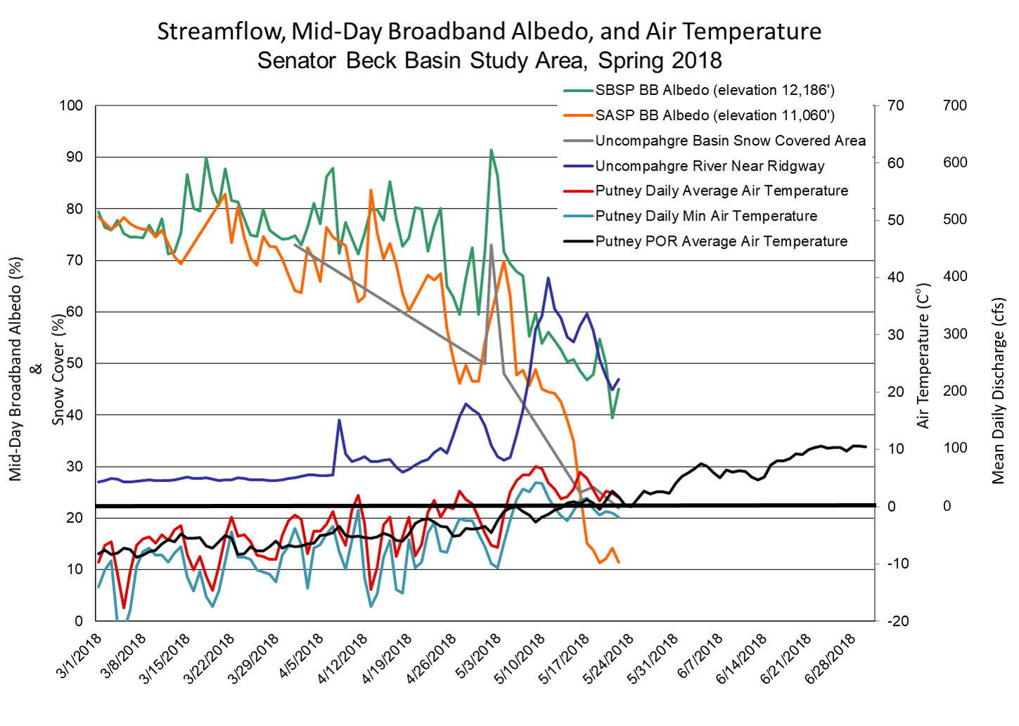
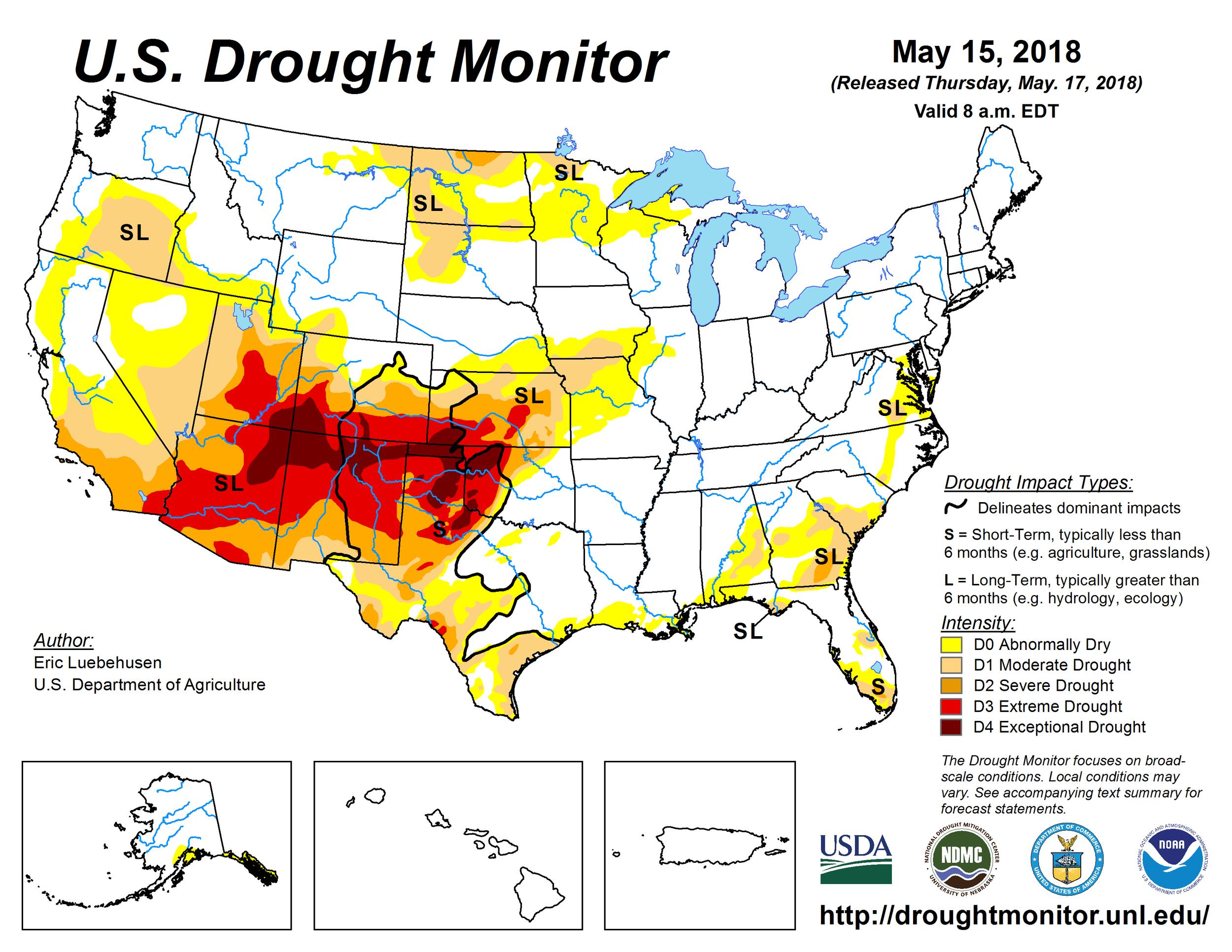
On May 14 and 15 we visited CODOS sites at Hoosier Pass, Loveland Pass, Berthoud Pass, Willow Creek Pass, and Rabbit Ears Pass to assess current conditions.  We observed nothing unexpected, events have been transpiring as we have reported, informed by our visits in March, April, and unfolding weather conditions.  Mainly, dust conditions have been solidly in the "Average" category statewide essentially since D5 occurred on April 12, and in the Southern Basins since late March/early April when D3/D4 occurred.  Within this "Average" categorization, conditions are largely consistent in severity at the Front Range and Northern CODOS sites, and also as observed at high elevations.  Higher elevations show pronounced dust coverage mostly on lee aspects and areas where the wind would be expected to subside and allow the dust to be deposited.    

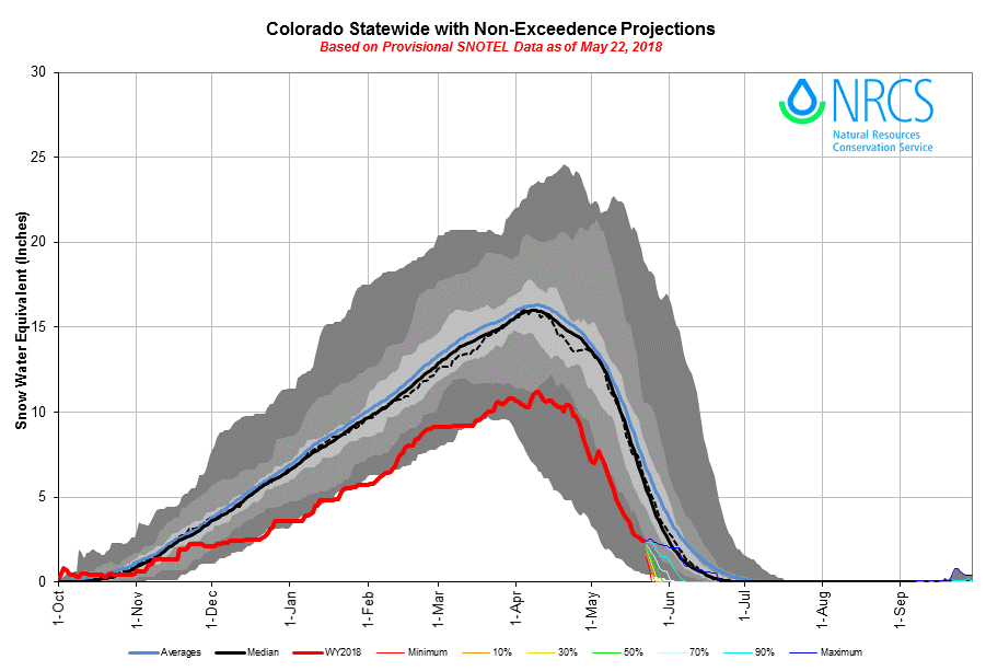
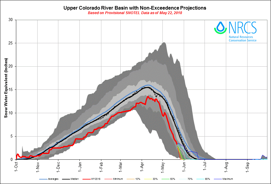
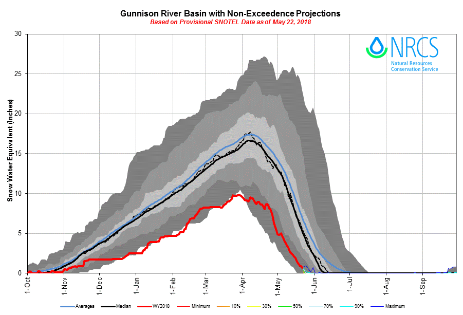
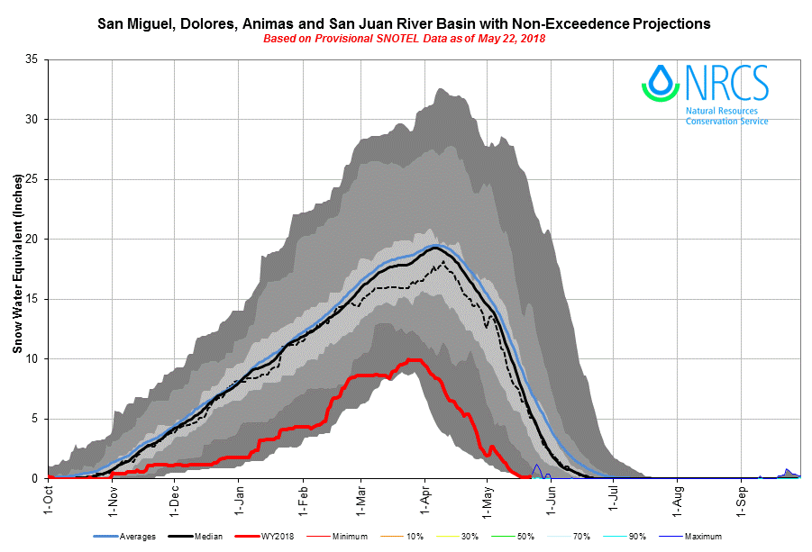
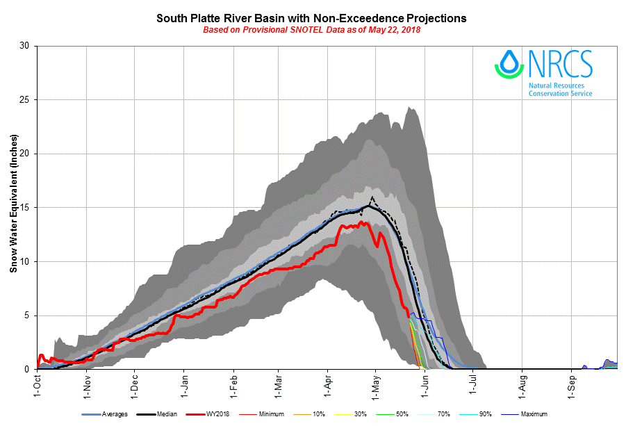
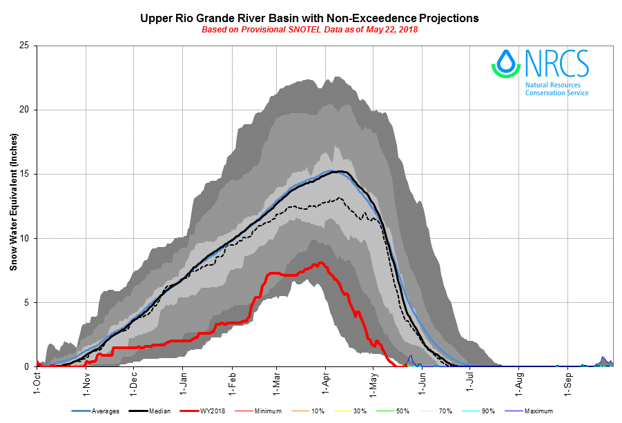
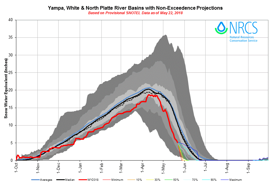
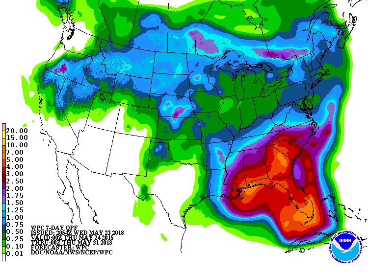
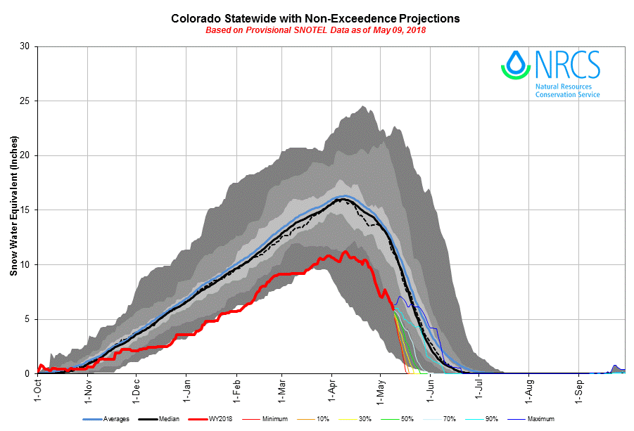
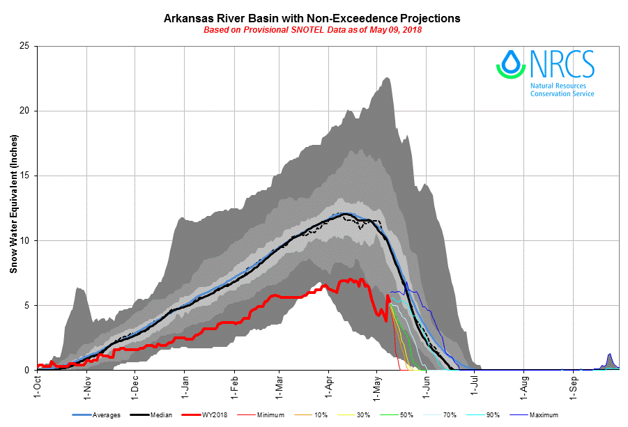
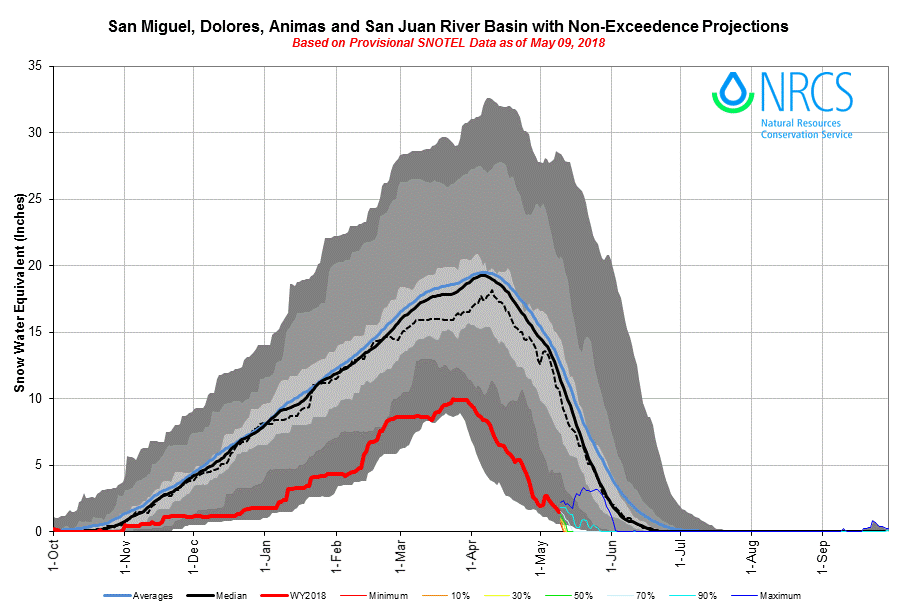
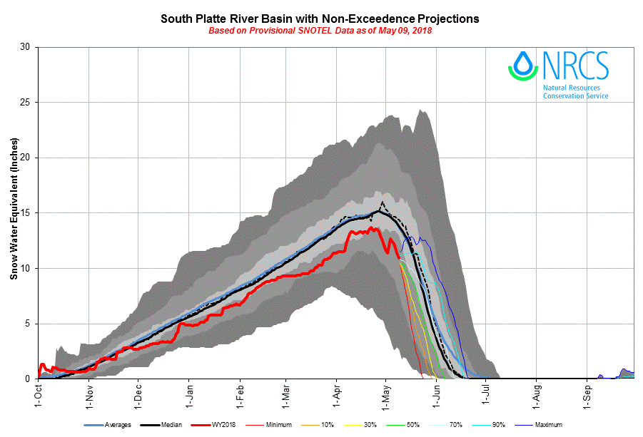
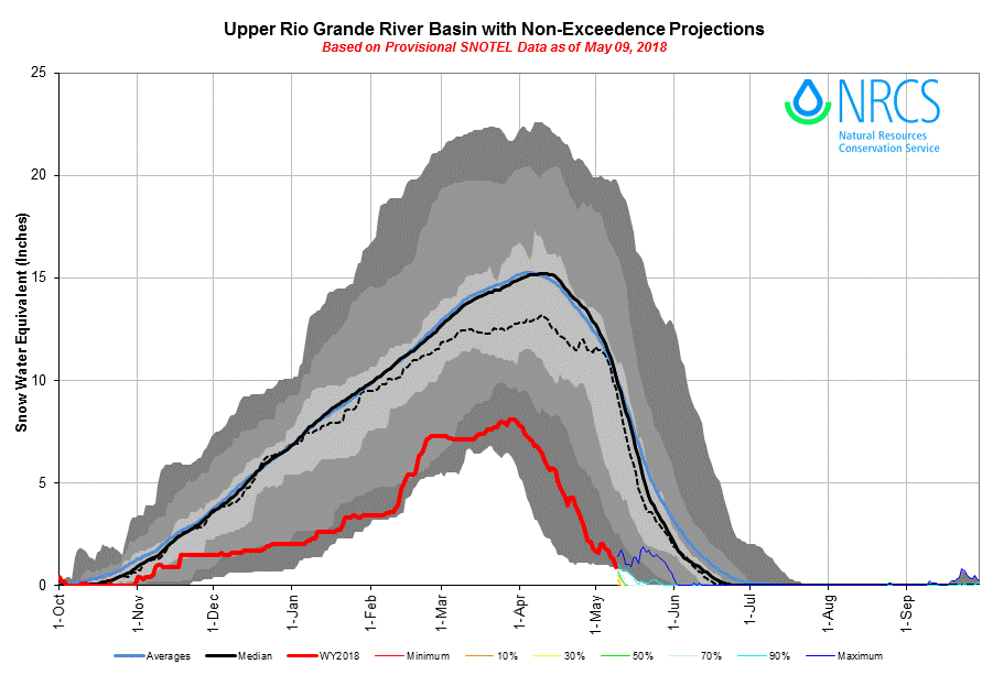
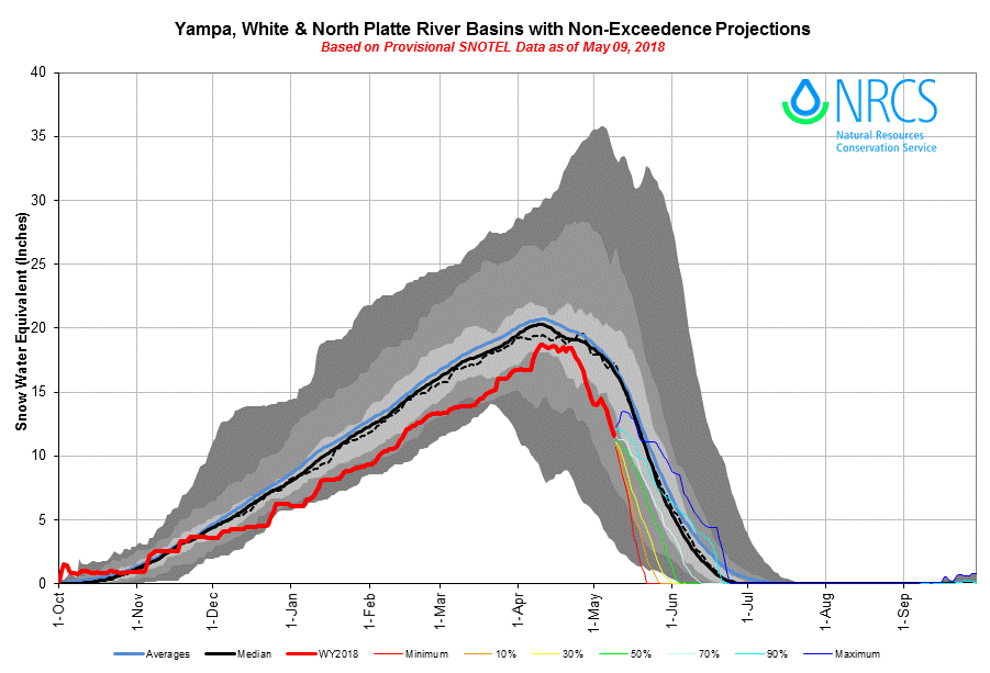
Spring weather occurring after April 1 added a nice boost to Central and Northern Colorado Basins resulting in peak SWE occurring well into April, but the Gunnison and Southern Basins largely missed out on these events and saw peak SWE occurring very near April 1.  The Central and Northern Basins benefited not only from the additional precipitation but accompanying short-term albedo resets.  Nonetheless the below average snowpack, dust conditions, and lack of notable spring storms mean Northern and Central Basins are on track to see SNOTEL melt out 2 - 3 weeks early than usual. 

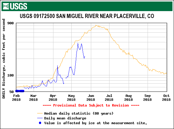
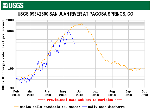
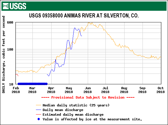
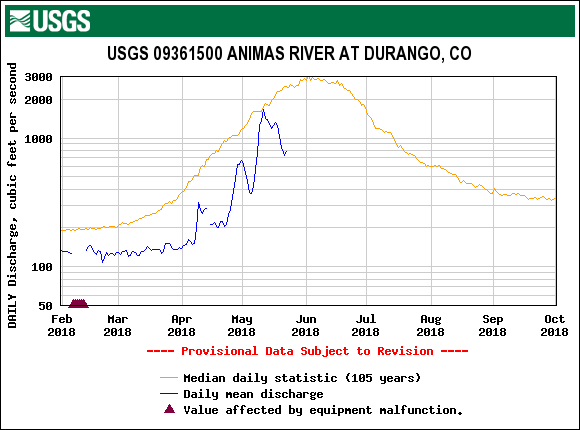
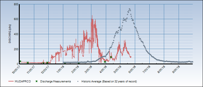
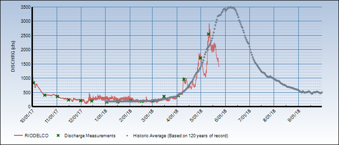
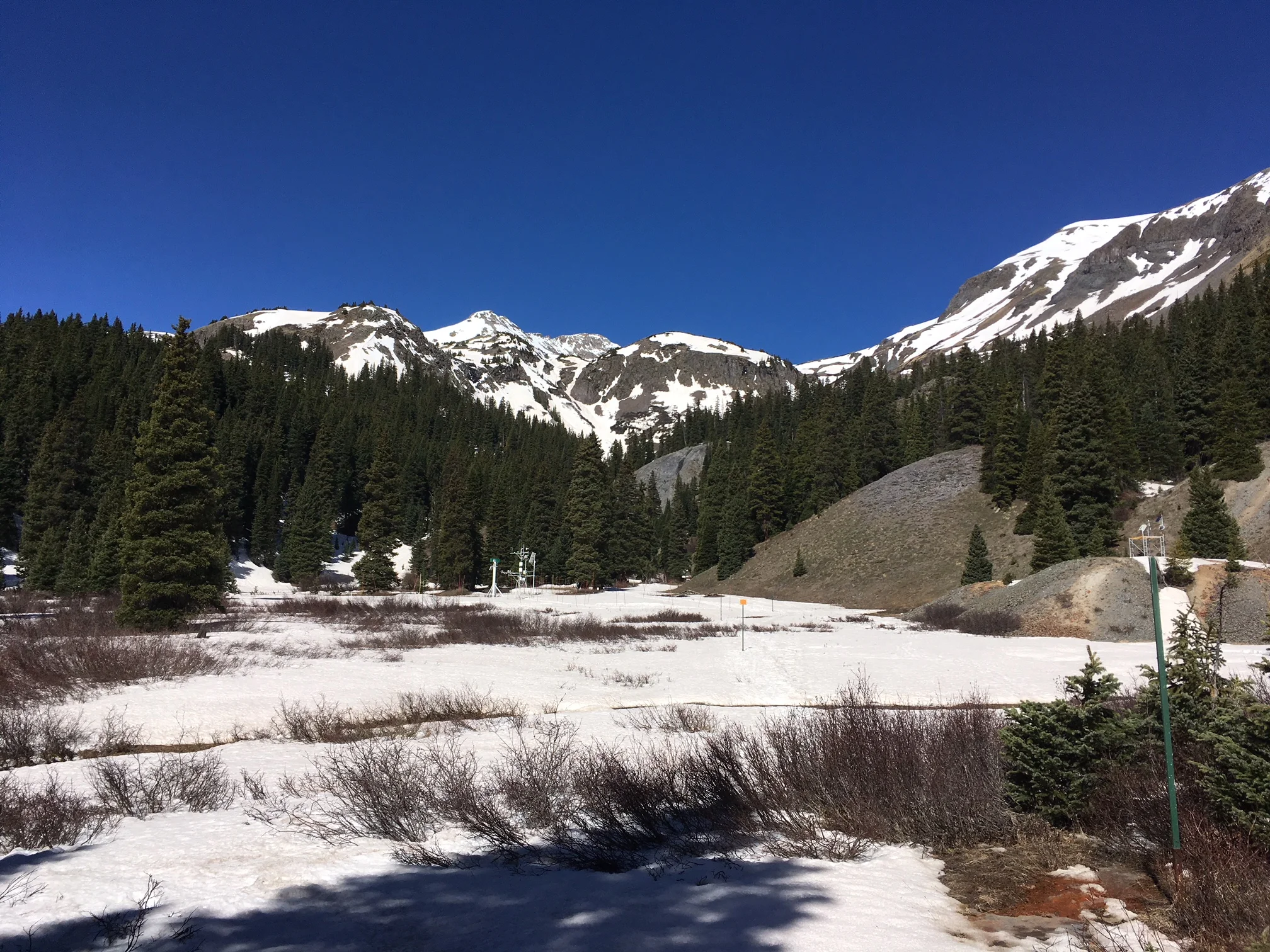
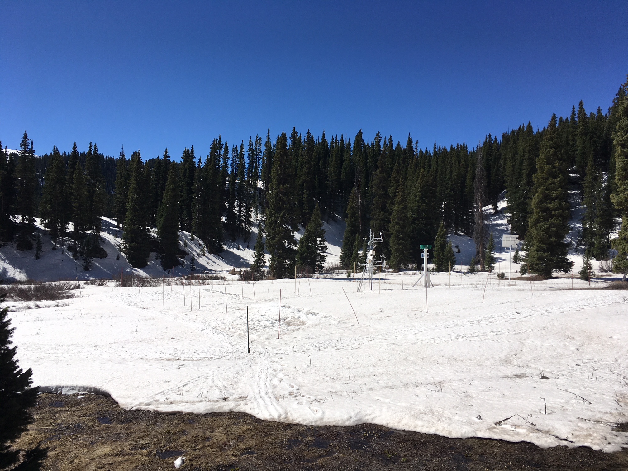
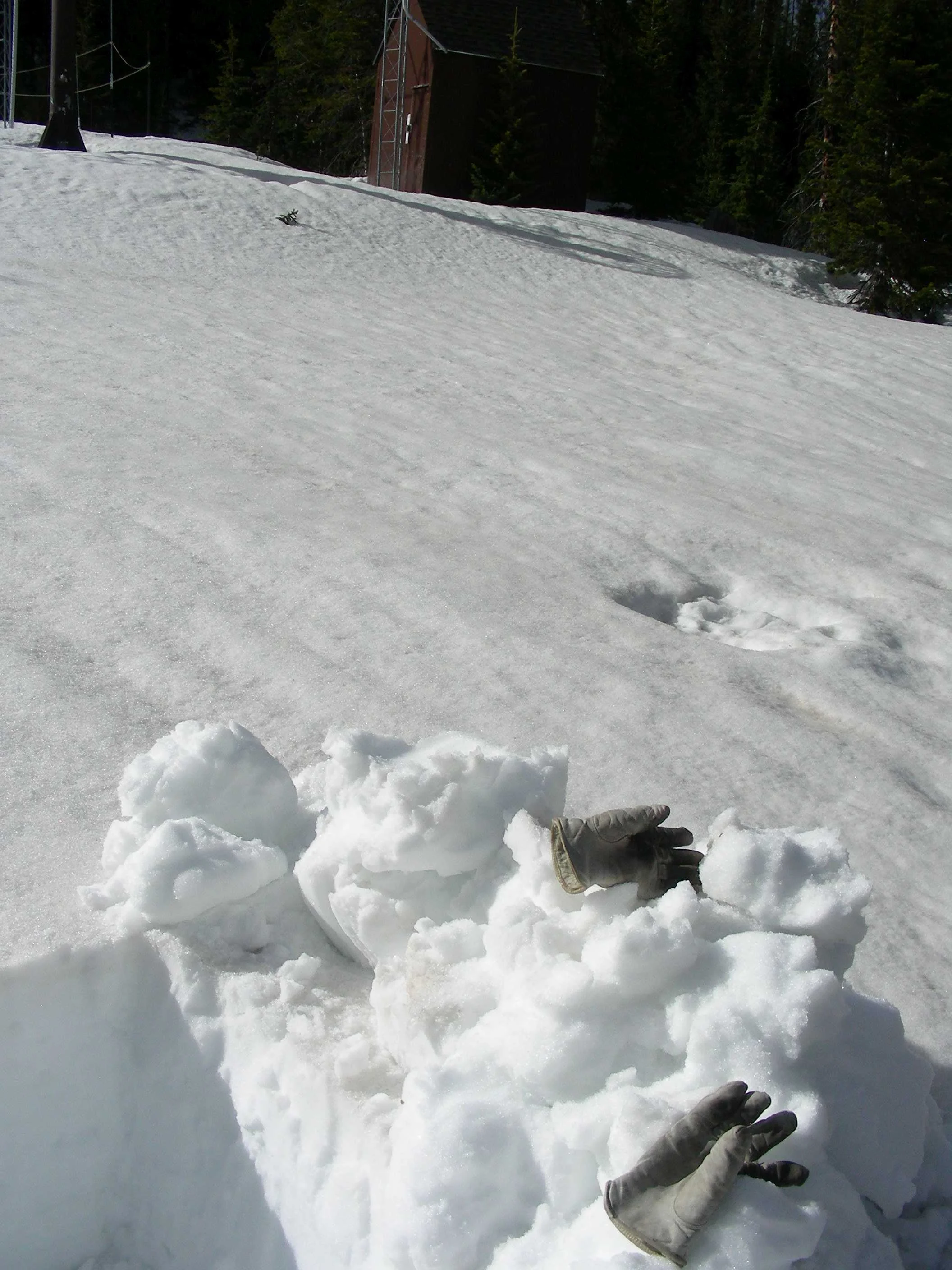
On May 15 we also made our usual observations at Swamp Angel Study Plot.  The snow depth sensor reports no snow as of May 16 at 1 pm.  As of May 14, snow profiles still show about 15" snow depth and 5.5" of SWE.  It has been an amazing, massive melt period in the San Juans since our last storm occurring May 1 -2 (we have not received precipitation at Senator Beck since May 2).  From May 8 - May 14, we lost 7.5" of SWE, that is over 1" SWE a day.  SNOTEL stations in the Animas/San Juan/Dolores/San Miguel are within a day or two of reporting snow-all-gone, at least 21 days earlier than the median date.  In the Rio Grande, Wolf Creek SNOTEL in a 10 day period (May 3 - May 12) lost 12.3" of SWE, that is 1.23" SWE/day.  SNOTEL stations in the Rio Grande are showing snow-all-gone as of a few days ago, 41 days earlier than the median date.  

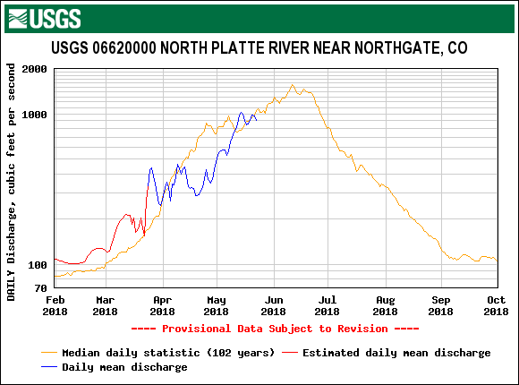
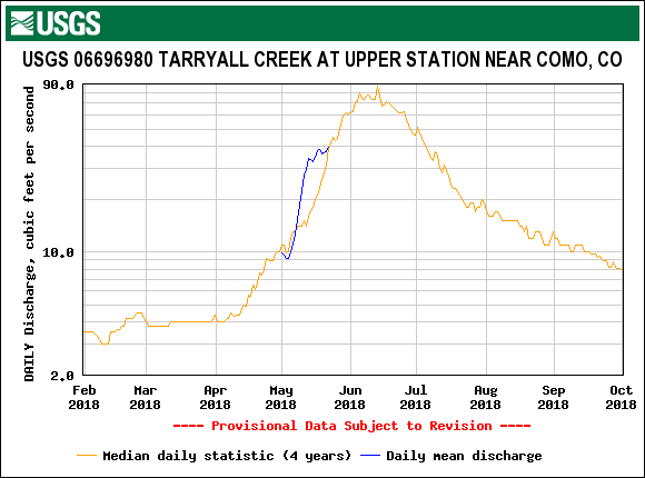
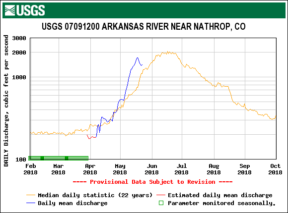
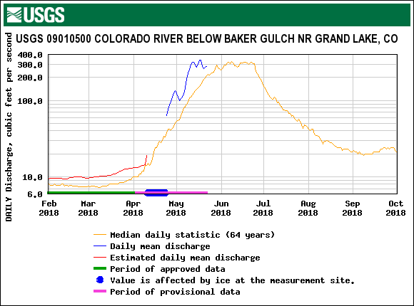
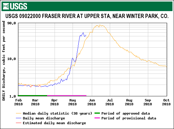
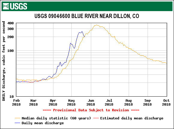
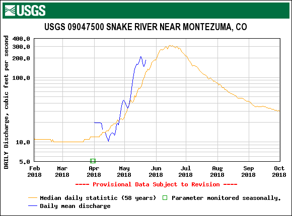
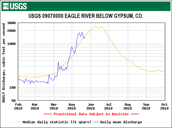
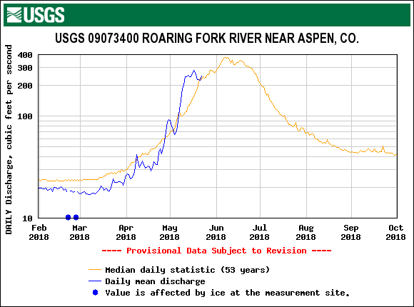
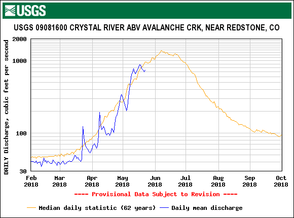
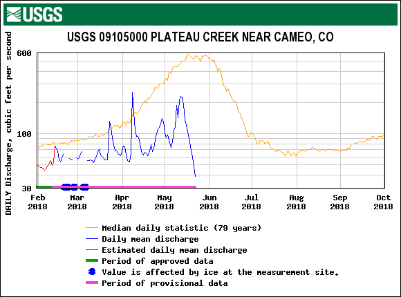
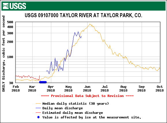
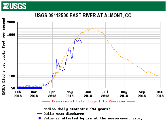
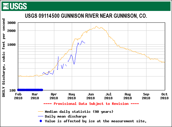
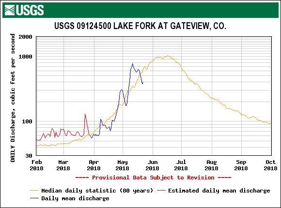
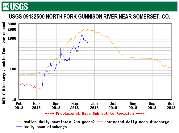
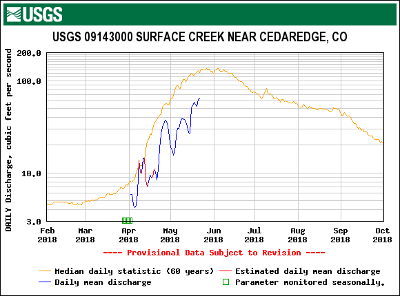
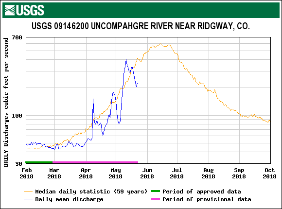
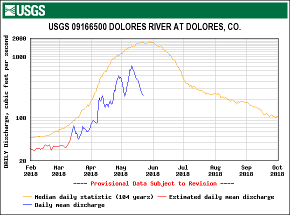
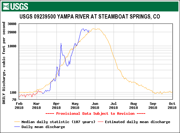
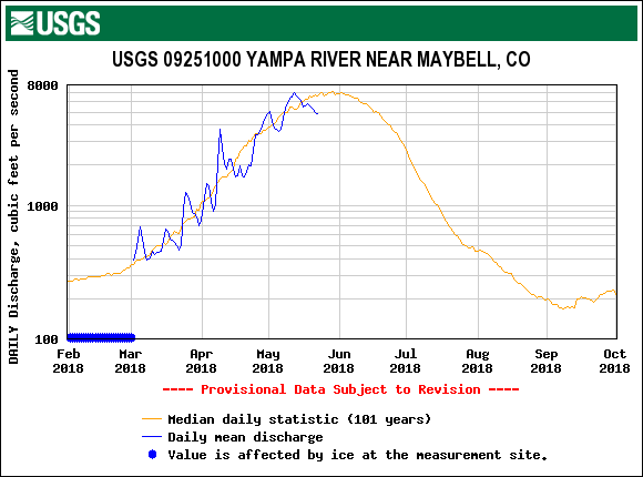
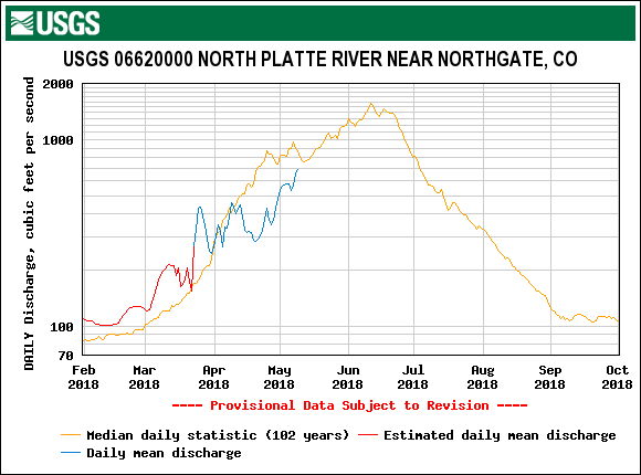
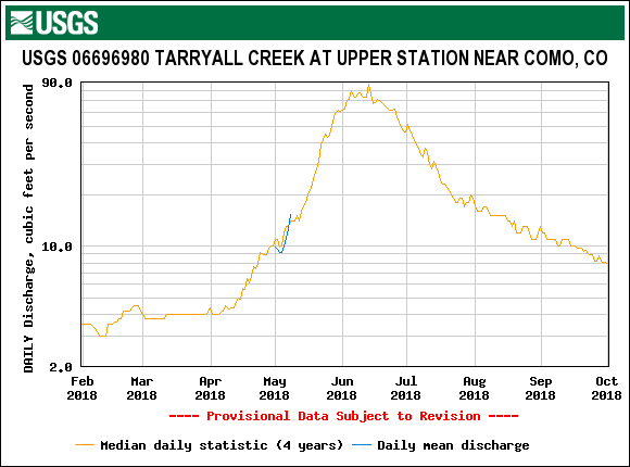
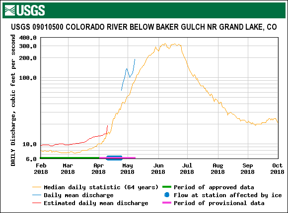
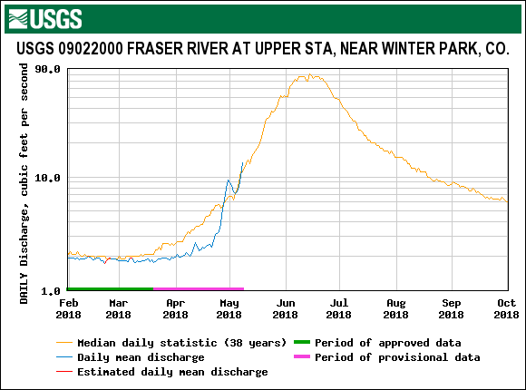
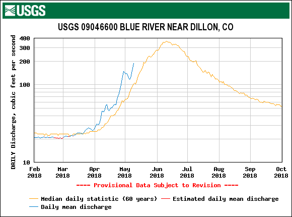
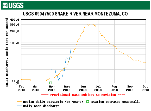
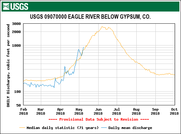
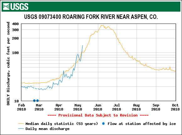
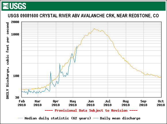
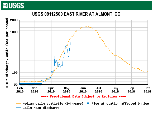
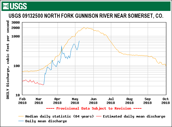
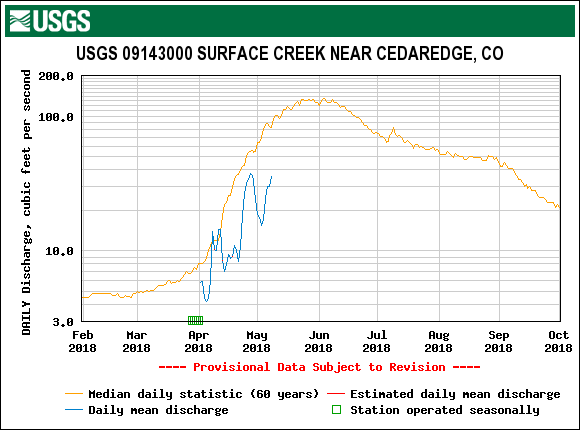
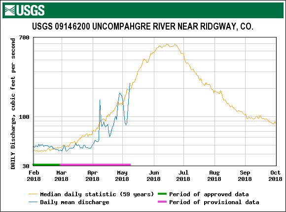
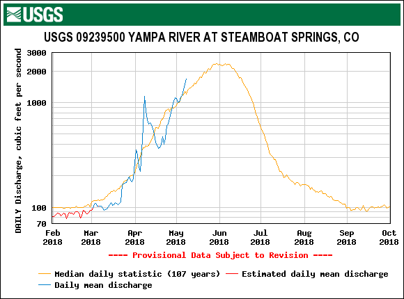
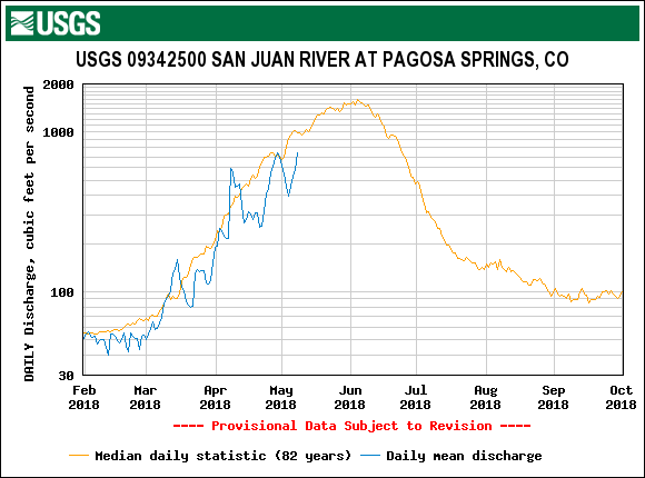
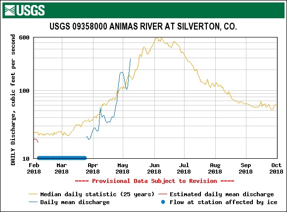
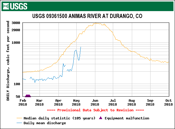
Streamflows have kept up a steep rising limb across the state, most notably in the Southern Basins, in response to the rapid snowmelt.  This has tapered off in the last couple days with cloud cover and a depleting snowpack in general is manifested.  There is still snow in the San Juans to be melted (please see pictures below), the location of which is creeping up in elevation plus some northerly aspects.  I plan to report more on this in a future Update (it was already introduced in the March 9 Update), but generally within a few days, when snow is gone from SASP is when 50% of cumulative streamflow from March 1 - June 30 has passed through the Senator Beck stream gauge.  And we are very near that point when snow is considered gone at SASP.   

Please see plots, pictures, and more comments/observations below.      

Swamp Angel Study Plot: May 15, 2018

Picture1.png

Albedo at Swamp Angel has taken a nose dive with snow cover depleting rapidly.  Senator Beck Study Plot has retained a little more snow than Swampy since May 2, but given its elevation (12,200') is melting quickly as well.  The forecast is sunny and above freezing temperatures until the weekend when chances of precipitation come into the picture.  

1.jpg

At 1 pm on May 16 snow depth under the sensor at Swamp Angel reported 0.  Senator Beck Study Plot shows 12" of snow remaining.  Streamflow took a short timeout from its upward trajectory in response to a couple days of improved albedo and cooler weather.  We have not seen precipitation since May 2.  Have we seen peak discharge at Senator Beck?  Good question.  I would not be surprised to see a higher peak given the clear and warm forecast the next couple days, and considering the amount of snow still remaining in the Basin.  Please see pictures below of Senator Beck Basin.  If it does not happen in the next few days, the inclement weather predicted over the weekend will likely slow down melt rates and resultant streamflow.

Clipboard01.jpg

Snow cover is nearly gone at SASP.  Where the snow profiles are conducted snow depth is currently around ~9".  From May 8 - May 14, we lost 7.5" of SWE, over 1" SWE a day.  

IMG_0882.JPG

May 14 at Swamp Angel.  Snow sensor reported 0" of snow depth on May 16 at 1 pm.  Although, there is still some snow yet to be melted.

Photo showing Swamp Angel and northerly aspects that still have snow.

Photo showing Swamp Angel and northerly aspects that still have snow.

Shallow snow pit shows snow remaining at Swamp Angel.  All layers merged samples were collected on this day (May 14).  

Shallow snow pit shows snow remaining at Swamp Angel.  All layers merged samples were collected on this day (May 14).  

Clean snow exposed to highlight dirty snow.

Clean snow exposed to highlight dirty snow.

Senator Beck stream gauge.  Stream still has snow/ice covering sections of stream that formed in early winter.

Senator Beck stream gauge.  Stream still has snow/ice covering sections of stream that formed in early winter.

Stream, Snow, and Forecast Plots

We are entering an active weather pattern but beneficiaries will be more eastern and northern areas of Colorado.   

We are entering an active weather pattern but beneficiaries will be more eastern and northern areas of Colorado.   

Hoosier Pass: May 14, 2018

Snow Profile at Hoosier Pass, May 14, 2018.  SWE is 10.7".  All dust layers at surface.

Snow Profile at Hoosier Pass, May 14, 2018.  SWE is 10.7".  All dust layers at surface.

Hoosier Pass.  Contrast between dirty snow surface and clean snow underneath.   

Hoosier Pass.  Contrast between dirty snow surface and clean snow underneath.   

Hoosier Pass.  Where there is snow at higher elevations, dust is easily visible in depositional areas.

Hoosier Pass.  Where there is snow at higher elevations, dust is easily visible in depositional areas.

Grizzly Peak (Loveland Pass): May 14, 2018

Snow profile at Grizzly Peak.  10.6" of SWE.  As elsewhere, all dust at surface.

Snow profile at Grizzly Peak.  10.6" of SWE.  As elsewhere, all dust at surface.

Looking up valley towards Loveland Pass from sample site.

Looking up valley towards Loveland Pass from sample site.

View towards A-Basin ski area from top of Loveland Pass.

View towards A-Basin ski area from top of Loveland Pass.

View towards the northwest from Loveland Pass.

View towards the northwest from Loveland Pass.

Berthoud Pass

Berthoud Pass snow profile, May 14, 2018.  SWE is 13.9".

Berthoud Pass snow profile, May 14, 2018.  SWE is 13.9".

Snow profile with SNOTEL in background.

Snow profile with SNOTEL in background.

Berthoud Pass.  

Berthoud Pass.  

Willow Creek Pass

Willow Creek on May 14, 2018.  Snow all gone at sample site.  Forested areas retain some intermintent snow.  

Willow Creek on May 14, 2018.  Snow all gone at sample site.  Forested areas retain some intermintent snow.  

Picture of high country from Willow Creek Pass sample area.

Picture of high country from Willow Creek Pass sample area.

Looking south from Willow sample area.  Intermittent snowcover in treed areas.

Looking south from Willow sample area.  Intermittent snowcover in treed areas.

Rabbit Ears Pass: May 15, 2018

Rabbit Ears snow profile.   SWE is 19.4".  

Rabbit Ears snow profile.   SWE is 19.4".  

View of snow pit and surrounding landscape at Rabbit Ears Pass.

View of snow pit and surrounding landscape at Rabbit Ears Pass.

Clean snow block in foreground to show contrast with dirty snow surface at Rabbit Ears.

Clean snow block in foreground to show contrast with dirty snow surface at Rabbit Ears.

Dust Alert D8

Dust Alert D8

Greetings from Silverton,

The Senator Beck Basin (SBB) received its eighth dust event of the season yesterday afternoon (May 11) and into the evening.  No surprise, the morning of May 11 Phil (CSAS employee) was driving through the four corners region on the way to Prescott and said it was white knuckle driving with the high winds and dust.  Then in the afternoon the San Juans started seeing the winds and hazy skies.  Dust cameras are showing dusty skies this morning so more dust is possible today (May 12).  This event is falling on an already dusty snow surface so it will be difficult, if not impossible, to assess its severity.   We will take mass loading samples and deduce loading of this event by subtracting out other sample weights from other individual dust events.  But the damage is already done.  The existing cumulative dust layers at the snow surface along with the relentless sunny/warm weather is melting the snow quickly.  In the last 7.5 days at Swamp Angel we lost 17.7" of snow depth.  Red Mountain SNOTEL lost 5" of SWE in the same time-frame, and currently shows 8.4" SWE remaining.  Wolf Creek lost 8.2" SWE and currently shows 3.8" remaining.  We will report on our findings for Northern and Front Range CODOS sites at mid-week.         

More from Silverton soon.

Photo from Abajo dust camera the morning of May 12. At the time of this writing more dust could be coming to the Colorado mountains.

Photo from Abajo dust camera the morning of May 12. At the time of this writing more dust could be coming to the Colorado mountains.

Winds have been straight out of the SSW for the duration of dust event #8

Winds have been straight out of the SSW for the duration of dust event #8

CODOS Update: May CODOS Tour Central/Southern Locations

CODOS Update: May CODOS Tour Central/Southern Locations

Greetings from Silverton,

The CODOS team visited Central and Southern sample locations May 9-10.  Snow was completely melted out at Wolf Creek, Spring Creek (which was already nearly fully melted out on April 16), and Park Cone sites.  Wolf Creek Pass has some snow cover on north facing slopes above 11,000 feet but is otherwise melted out.  At Grand Mesa there is absolutely no snow below 10,000', which has been the case for some time, with about 90% of snow coverage on the Mesa itself.  At the Grand Mesa CODOS site we observed only 10" of snow depth and 3.6" of SWE, with dust conditions on the upper end of average (pretty dirty).  Dust conditions are classified as "Average" across the state, but there is a little variation in dust intensity within that designation.  The San Juans and Grand Mesa are on the high end of average, while Northern Colorado and Front Range locations sit more in the middle part of average. 

In a nutshell, the snow surface is quite dirty.  The snow is melting fast after the rain and wet snow event on May 1-2, which deteriorated quickly giving rise to all dust layers at the surface of the snow.  In response streamflows have been spiking.  Seasonal peaks are expected at many locations with this melting surge.  Given the weather forecast and dust conditions, projection plots show SNOTEL stations in the Rio Grande are on track to be melted out over a month earlier than normal.  The San Juan/Dolores/San Miguel/Animas Basin will be about a month early.  The Gunnison is on track to melt out about 3-4 weeks earlier than the median date.   

The weather forecast over the weekend has changed from a good chance of snow/rain in the San Juans to sunny and windy.  Added to that in the four corners region there is a wind advisory with expected areas of blowing dust.  So instead of a chance of rain/snow we can expect it to be sunny/windy with a chance of more dust deposition on an already dirty snow surface - accelerating snowmelt and sublimation rates even further.  As you go towards Northern Colorado chances of precipitation increase, mostly in the form of rain except at higher elevations.  It does not appear the majority of the mountain regions are going to receive any reprieve from current conditions in the near future.  The remainder of May is forecast to be warmer and drier than average across the Southwest.

Please see pictures, captions, and plots below.

We will assess Northern Colorado CODOS sites in a couple days and report our findings ASAP.

More soon.

Wolf Creek Pass.  Picture captures snow-all-gone conditions on southerly aspects and snow cover still remaining at higher elevations and northerly aspects.  

Wolf Creek Pass.  Picture captures snow-all-gone conditions on southerly aspects and snow cover still remaining at higher elevations and northerly aspects.  

Wolf Creek CODOS sample site essentially completely melted out.  This site has a SSW aspect, across the highway the Wolf Creek SNOTEL reports 7.3" of SWE remaining.  

Wolf Creek CODOS sample site essentially completely melted out.  This site has a SSW aspect, across the highway the Wolf Creek SNOTEL reports 7.3" of SWE remaining.  

Wolf Creek Pass, looking at southerly aspects of the landscape showing snow-all-gone.  

Wolf Creek Pass, looking at southerly aspects of the landscape showing snow-all-gone.  

Spring Creek Pass was nearly completely melted out on our last CODOS visit on April 16.  Now there is no snow to be found anywhere in the area.   

Spring Creek Pass was nearly completely melted out on our last CODOS visit on April 16.  Now there is no snow to be found anywhere in the area.   

Looking in a northerly direction at Spring Creek Pass.

Looking in a northerly direction at Spring Creek Pass.

Looking toward Lake City from Slumgullion Pass.  From where this photo was taken, dust was easily seen on the 14,000' peaks (on right side of picture).

Looking toward Lake City from Slumgullion Pass.  From where this photo was taken, dust was easily seen on the 14,000' peaks (on right side of picture).

Looking out over Taylor Park Reservoir.  Mid/Lower elevations are melted out but more snow exists in the high country than what is seen in the San Juans.  

Looking out over Taylor Park Reservoir.  Mid/Lower elevations are melted out but more snow exists in the high country than what is seen in the San Juans.  

Grand Mesa sample site.  10" of snow depth and 3.6" SWE remains.  All dust layers are at the surface.  

Grand Mesa sample site.  10" of snow depth and 3.6" SWE remains.  All dust layers are at the surface.  

Approaching the Grand Mesa dust sample site.

Approaching the Grand Mesa dust sample site.

Look out over Grand Mesa.

Look out over Grand Mesa.

Picture1.png
q and depth.jpg
95ep48iwbg_fill.gif

CODOS Update: D2-D7 Back at the Snow Surface, It's Dirty

CODOS Update: D2-D7 Back at the Snow Surface, It's Dirty

Greetings from Silverton,

The 11” of snow accumulation received May 1-2 has now melted down to where dust events 2-7 once again are at the surface of the snowpack at Swamp Angel, Senator Beck and majority of the surrounding landscape.  With the warm and sunny weather since the 1st of May storm, SNOTEL data across the state are now beginning to report snow depths and water equivalent at or below values prior to the storm, indicating dust is fully exposed at all monitoring points.  The combined dust events are bordering between "average" and "maximum" dust severity.  We have had only 2 previous years that achieved the status of "maximum" dust severity in our period of record.  As of right now we will classify severity conditions as "high end of average", but his may change with further data analysis.  Please see plots and captions below discussing this past week in more detail.     

Average and minimum air temperatures are staying above freezing and the forecast is for this to continue.   Over the next 7 days Southwest Colorado is expected to receive around only 0.10"-0.14" precipitation in the mountains, as you move east and north precipitation amounts are expected to increase with the mountain regions expected to see anywhere from 0.23"-0.65".  Besides possibly seeing a day of cloud cover (tapping the brakes on snowmelt), it is supposed to remain sunny.  With the season's dust now completely at the surface, above freezing minimum temperatures, negligible precipitation and sunny days in the forecast, the faucet is turned on in terms of melting what little snow exists in Central and Southern Colorado.  Northern Basins which are faring a little bit better - Yampa/White, South Platte, Colorado Mainstem - are projected to hold onto snow into June, but dust exposure might have something to say about that unless wetter spring conditions prevail in these Basins than are expected in the Southern part of Colorado.  

Please see plots and below.

More soon.

This morning, May 8, at Swamp Angel Study Plot.  All layers are now merged.

This morning, May 8, at Swamp Angel Study Plot.  All layers are now merged.

This morning, May 8, going up towards Senator Beck Study Plot.  The dust severity can be seen by comparing ski tracks and sloughed areas.  

This morning, May 8, going up towards Senator Beck Study Plot.  The dust severity can be seen by comparing ski tracks and sloughed areas.  

The May 1-2 storm brought 0.9" of water and 11" of snow accumulation plus initiated a major albedo reset.  But, given the wet snow that was deposited, sunny days and above freezing air temperatures at night. snowpack albedo decayed rapidly as i…

The May 1-2 storm brought 0.9" of water and 11" of snow accumulation plus initiated a major albedo reset.  But, given the wet snow that was deposited, sunny days and above freezing air temperatures at night. snowpack albedo decayed rapidly as it gradually gave rise to dust layers 2-7, resulting in a spike in streamflow.  Currently,  the forecast is for continued above freezing minimum temperatures and sunny conditions.  With D2-D7 now at the surface, we are going to continue to see rapid snowmelt.  Over the weekend we may see a chance of precipitation, we are not expecting much (forecast is calling for 0.14" over the next 7 days), but it might provide cloud cover for a day or two, possibly slowing down melt only temporarily.  

Above plot shows snow depth, albedo, and streamflow at our SBB gauge.  Interestingly, on May 1 median snow depth at SASP and SBSP cross over, where the snowpack begins rapid ablation at SASP and the higher elevation SBSP holds onto the snow lon…

Above plot shows snow depth, albedo, and streamflow at our SBB gauge.  Interestingly, on May 1 median snow depth at SASP and SBSP cross over, where the snowpack begins rapid ablation at SASP and the higher elevation SBSP holds onto the snow longer into the summer and creates the second peak seen in the median streamflow data.  This year, we are about a month earlier than normal.  SBSP will likely hold onto the snow longer than SASP but not by much.  

sasp.jpg
sbsp.jpg
p168i.gif