

SUMMARY
Final CODOS visits were conducted at Hoosier, Loveland, Berthoud, Willow Creek, Rabbit Ears, and McClure Pass sites on June 16 and 17, and Independence Pass was also visited on June 15. Merged but comparatively weak dust-on-snow was observed at the snowpack surface in all locales, producing an incremental but still meaningful reduction in snow albedo and absorbing solar radiation, but other sources of energy had driven the snowmelt energy budget until recently. Dust samples were collected at Independence, Loveland, and Berthoud Pass sites. Very high streamflows were observed in these watersheds. A discussion of the pattern and high amplitude of recent statewide snowmelt behavior is presented.
DUST-ON-SNOW CONDITIONS
As CODOS program participants know, no additional dust-on-snow events were observed by CODOS at the Senator Beck Basin (SBB) sentry site since the D3-WY2015 event of April 14/15 (see Dust Log). The total WY 2015 mass of mineral dust deposited to-date at the Swamp Angel Study Plot in SBB, from events D1 (April 2), D2 (April 8) and D3 (April 14/15), is 2.048 grams per square meter (2 g/m2), a small fraction of the dust depositions observed in prior seasons (see Mass Loading Data). As such, WY 2015 dust intensity at SBB and throughout the state ranked as comparatively minimal (i.e., MIN Dust) within the CODOS period of record and within the Dust Enhanced Runoff Classification scheme.
During this CODOS circuit, dust event layers D3, and perhaps D2 and D1 (where present) were observed merged in a single layer at the snowpack surface on all aspects and at all elevations. Viewed from a distance, most remaining snowcover appeared ‘clean’, although not as clean as seen during May, when new snow repeatedly restored very high snow albedo throughout the Colorado mountains. However, closer inspection revealed that this merged dust at the surface was darkening the snow surface and producing a comparatively minor reduction in albedo. While not as dramatic as in prior years, this incremental reduction in albedo was enhancing the radiative forcing of snowmelt, adding additional absorbed solar energy to the snowmelt energy budget.
“All layers merged” (ALM) samples of this dust were collected at Independence Pass, near the summit of Loveland Pass, and at the Berthoud Summit CODOS site (see photos below). These ALM samples were sent to our USGS collaborators for chemical and other analyses, for inter-site comparison. ALM samples were not collected at Hoosier Pass, Willow Creek Pass, Rabbit Ears Pass, and McClure Pass due to lack of snow at or near the CODOS site.
Collecting an “all layers merged” (ALM) sample of D3/D2/D1 at Independence Pass on June 15, 2015. This location, where wind drifting had concentrated dust into a ‘dune’ during wet deposition, was selected for this ALM sampling in order to maximize the amount of dust contained in the volume of snow packed into the two Nalgene bottles. At this spot of concentrated dust, albedo is more reduced than at a site just a few yards farther west, between ‘dunes’ (as seen below).
Most snow covered terrain in the Independence Pass locale displayed the kind of dust intensity seen in this photo, showing the merged dust layer in a space between the scattered ‘dunes’ of more concentrated dust seen in the photo above, and in the distance in this photo. The dark band below the snowpack surface is a layer of ice stained by infiltrating melt water containing very fine dust particles.
The Hoosier Pass CODOS site on June 16, 2015, near treeline, with rapidly melting and highly variable snowcover.
Dust layer D3, perhaps merged with layers D2 and D1, was present at the Hoosier Pass snowpack surface mixed with almost the entire winter’s worth of heavy vegetation debris and with recently deposited yellow pollen. Collecting a useful “all layers merged” sample was not feasible at or near this Hoosier Pass site.
At Loveland Pass, on June 16, 2015 the CODOS Grizzly Peak snow profile site was complete snow-free.
A site above treeline and adjacent to Pass Lake, just west of the Loveland Pass summit, was utilized to collect an “all layers merged” sample of dust layer D3 potentially merged with layers D2 and D1. This site minimized the potential for contamination from the highway corridor. Recent rains had clearly saturated the snowpack and leached some fine dust material into the snowcover. Dirt and rock entrained in avalanches had also stained the snow seen in the background.
This view on June 16, 2015 of the upper Arapahoe Basin ski area, recently closed, clearly shows the concentration of Colorado Plateau dust in patches produced by wind drifting during wet dust-in-snow deposition on lee slopes, where blowing new snow containing dust decelerates and deposits.
On June 16, 2015 the Berthoud Summit CODOS snow profile site retained a few inches of sun-cupped snow. Most of the snow pillow at the Snotel site in the background was snow-free at the time. An “all layers merged” (ALM) sample consisting of at least dust layer D3 and potentially layers D2 and D1 was collected from the rough snow surface immediately to the right of the shovel, with minimal quantities of vegetation debris.
The Willow Creek Pass CODOS snow profile site, in the foreground, had long-since become completely snow-free on June 16, 2015, as were the snow course and the adjoining Snotel site at the other edge of this meadow. Snowcover in this locale had retreated to high on the flanks of nearby Parkview Mountain.
The CODOS snow profile site at Rabbit Ears Pass, located in this northeast sloping wetland, was also completely snow-free on June 16, 2015. No “all layers merged” sample was collected due to the extremely heavy vegetation contamination of the small patches of snow in the adjoining trees.
Snowcover was also long-since “all gone” at the McClure Pass Snotel and adjoining CODOS snow profile site on June 17, 2015.
SNOWPACK & PRECIPITATION CONDITIONS
During this late-season circuit of Independence Pass and the Hoosier Pass, Grizzly Peak/Loveland Pass, Berthoud Pass, Willow Creek Pass, Rabbit Ears Pass, and McClure Pass CODOS sites, either no snow or only very shallow snowcover remained so no new formal snow profiles were performed. Evidence was seen of significant, high-elevation rains preceding these site visits by a day or two. Snowcover had retreated to treeline and above in these locales (see photos below).
Shallow snowcover on Independence Pass, on June 15, 2015 was rapidly melting and exposing willows and bare ground. Solar radiation absorbed by these ‘dark elements’ and then re-emitted as thermal (longwave) energy rapidly accelerate snowmelt around their perimeters. The summit of the Pass is seen in the middle distance, with sunlit La Plata Peak (14,361’) in the far distance, on the right.
Mt. Lincoln (14,296’) seen from Hoosier Pass on June 15, 2015
Looking south across the Blue River inlet on Dillon Reservoir at the 10 Mile Range and the Breckenridge ski area in the distance on June 16, 2015
Looking south from Loveland Pass at (from left to right) Grizzly Peak (13,427’), Lenawee Mountain (13,201’), and the Arapahoe Basin ski area, on June 16, 2015.
Ascending Berthoud Pass from the east on June 16, 2015 with Engelmann Peak (13,362’) seen across the West Fork of Clear Creek valley.
Snowcover in the upper Willow Creek drainage was rapidly melting on Parkview Mountain, seen on June 16, 2015 from the Willow Creek Pass CODOS site.
Snowcover on the Rabbit Ears Pass plateau on June 16, 2015 was limited to very small, scattered patches under trees on north-facing slopes.
As in other locales, by June 17, 2015 snowline had retreated to treeline and above in the upper Crystal River watershed and appeared, at a distance, comparatively ‘clean’.
As previously discussed in the prior June 4 Update, May 2015 produced abundant and even record amounts of precipitation throughout the Colorado mountain system, much or most of it as snow. Early June added still more snow as well as rain-on-snow at high elevations, and considerable rain below the snowline. Although most Basins had experienced significant losses of snowcover earlier, May did produce some maintenance of or rebound in snowpack SWE levels in all Basins (and Peak SWE in the South Platte Basin), as seen in the basin-scale SWE plots below, combining all Snotel data in the respective watersheds (and Statewide).
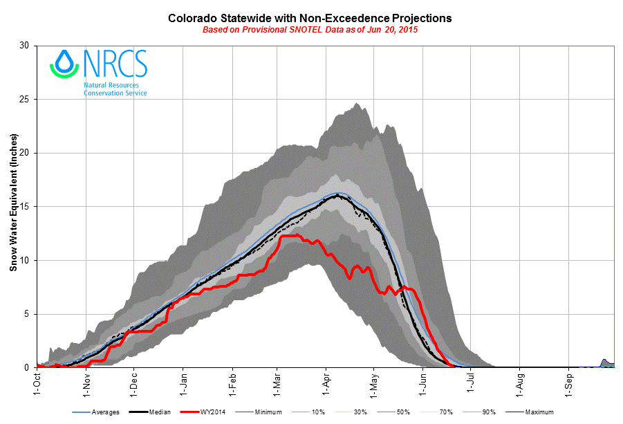
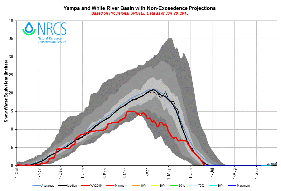
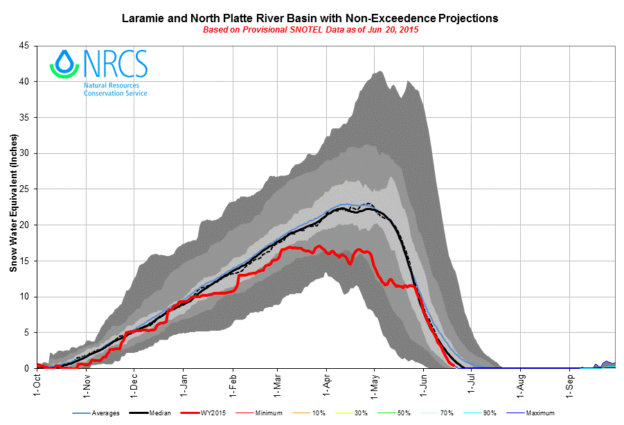
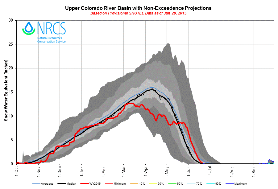
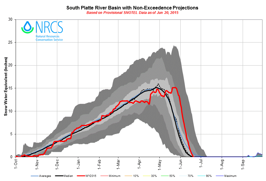
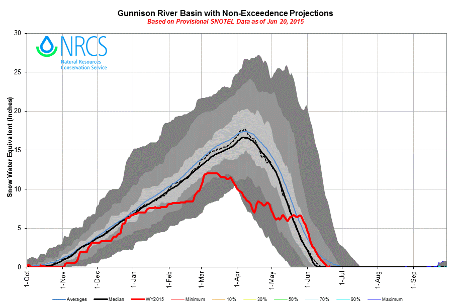
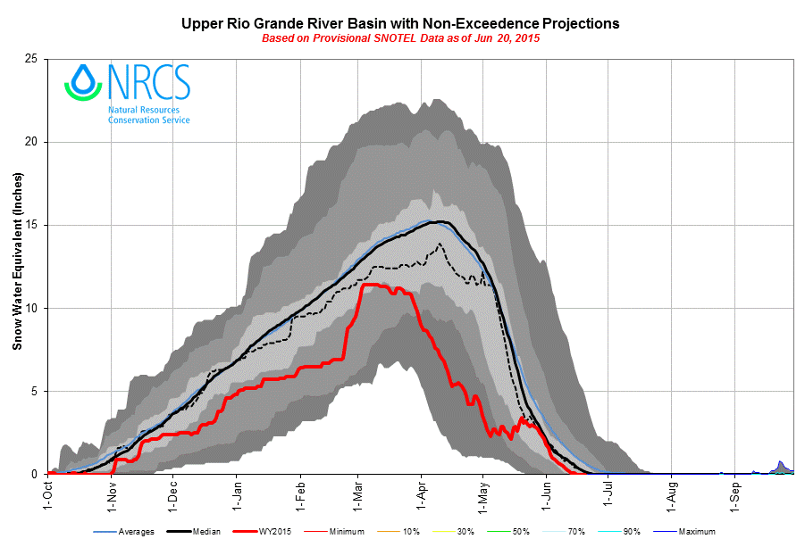
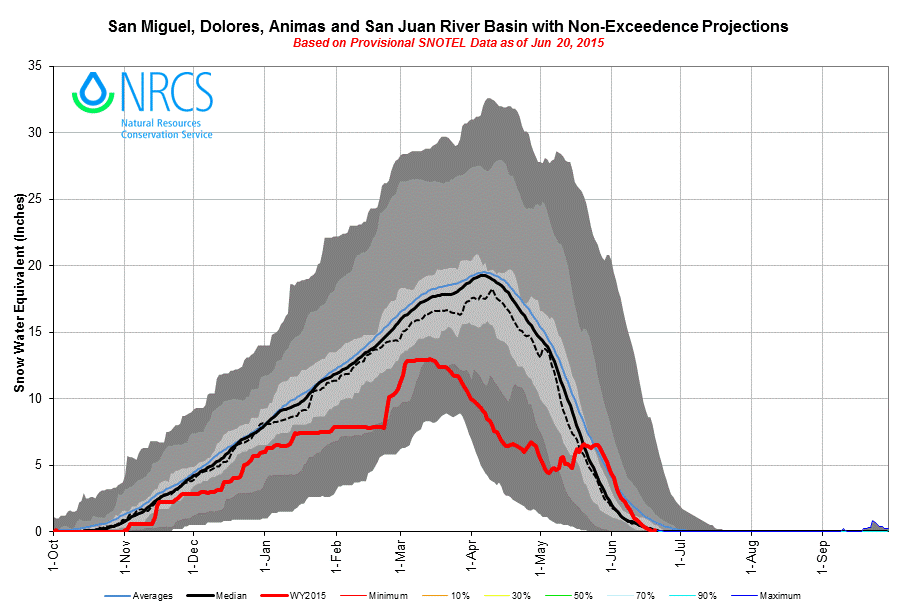
At all but one of the fifteen Snotel sites that CODOS routinely monitors, very poor March/April/May precipitation totals as of May 15 were largely reversed by the end of May. Under the CODOS Dust Enhanced Runoff Classification criteria for precipitation, conditions by the end of May had improved from DRY Spring conditions at all but two sites to AVG or WET Spring precipitation conditions at all sites (AVG Spring = median March/April/May total +/- 15%). With their typically higher elevations, most CODOS Snotel sites received much or most of this precipitation as snow rather than rain. The McClure Pass, Rabbit Ears Pass, and Willow Creek Pass Snotel sites, at 9,400-9,500’ are the lowest of these sites and likely received a larger proportion of their May precipitation as rain or sleet that the other sites.
Thanks to abundant precipitation in May, combined March/April/May precipitation values fell within the AVG Spring or WET Spring categories of the Dust Enhanced Runoff Classification scheme (above). The extremely wet latter half of May produced this reversal from the DRY conditions reported in mid-May (below).
However, despite better-late-than-never snowfalls in May, Colorado SWE plots still fell short of 1981-2010 median SWE content in many basins and at many individual Snotel sites. Overall, as the Colorado Statewide plot of all Snotel data presented above indicates, the area underneath the plot of WY 2015 daily SWE values is substantially smaller than the area under the mean and median traces, suggesting a substantial deficit in total SWE available for snowmelt runoff. At the scale of major basins, some fortunate storm behaviors favored both the South Platte River and Arkansas River Basins with the most ‘normal’ SWE plots, salvaged by the final burst of May snow. Elsewhere, despite May, the North Platte, Yampa, Colorado, Gunnison, Rio Grande, and southwestern River Basins all seem to have fallen short, some far short, of accumulating normal snowpacks and SWE during WY 2015. However, adding a final twist to Water Year 2015, snowmelt runoff behavior has been (arguably much) more intense than these SWE data would suggest. In fact, these SWE plots may obscure the total, cumulative quantity of SWE available for melt and runoff during this highly erratic snowpack accumulation/ablation season.
RUNOFF BEHAVIOR
Current hydrographs have been posted to all CODOS site webpages. Almost without exception, these hydrographs show very high peak flows recently occurring on or even beyond the median date of peak discharge. Some gauges recorded a second, earlier peak flow at or near the later, most recent peak level. Some gauges are still reporting ascending levels, others have stabilized at near-peak levels, and a few gauges have just begun their descending limb.
Utilizing the CODOS Dust Enhanced Runoff Classification (DERC) analyses of WY 2006-2014 snowpack, dust, and spring precipitation conditions, the May 18, 2015 Update presented a discussion of ‘best fit’ historical hydrographs that might preview WY 2015 runoff patterns. Given generally LOW March 1 SWE conditions, MIN Dust to-date, and DRY Spring (March/April/May) total precipitation conditions to-date, WY 2012 and WY 2007 offered the best, albeit imperfect, precedents from the CODOS period of record for how WY 2015 snowmelt runoff hydrograph patterns might continue to evolve. However, as May fully unfolded, as the wettest May in Colorado history, it became clear that this season had produced a new and unique set of DERC conditions.
As stated in that May 18 Update, the short 2006-2014 period of CODOS observations has not yet captured all combinations in those three parameters – March 1 SWE, Dust intensity, and March/April/May precipitation. By mid-May, WY 2015 had already exhibited a new set of conditions within and even outside the DERC scheme that were determining snowmelt runoff behavior including very early development of isothermal snowcover unrelated to dust effects, significant rain and rain-on-snow events, and the most minimal dust loading observed in the CODOS record. Subsequent to that May 18 Update, heavy and even record precipitation during the remainder of May, as snow and rain, added yet another wrinkle to the unusual patterns of WY 2015 runoff behavior. Here at Senator Beck Basin we measured almost 8” of precipitation during May, virtually all as snow.
During May, with no additional dust-on-snow events since D3 (April 14/15), the minimal dust present in the snowcover remained well buried and did not significantly enhance the ongoing but low snowmelt rates producing increasing runoff throughout May. May’s snowfalls did not re-cool the remaining snowpack to any significant degree and rain-on-snow added (thermal) heat to some lower elevation snowcover. The snowcover remained effectively isothermal throughout the month, sustaining some snowmelt discharge, augmented by sometimes heavy rains just at and below snowline. In very late May and early June the return of clear skies, the sun, and much warmer and drier weather was again disrupted by two significant June rain events.
During the periods of sunny weather, increases in solar (shortwave) radiation from rapidly lengthening days and higher sun angles, increased thermal (longwave) radiation from absorbed and re-emitted solar energy by vegetation and bare ground, and higher air temperatures all combined to rapidly increase snowmelt energy, even with very high snow albedo where clean May snows still shielded the underlying merged dust layer from solar radiation. Under those conditions, during clear nights, with no incoming solar and with significant outgoing losses of thermal energy, the snowpack marginally ‘cooled’ and partially offset the daytime energy inputs, creating a strong diurnal cycle in the energy budget and snowmelt discharge.
As a direct result of those sunnier, warmer, and drier conditions, virtually all headwater hydrographs that CODOS monitors presented a very steep and large surge during the sunnier days of late May and early June, up from relatively static or slowly increasing May streamflow levels. Dust-on-snow, and reduced snow albedo, did not play a major role in producing much of that May surge – ‘normal’ energy exchanges drove that snowmelt behavior. More recently, in the watersheds recently visited (and here in the Southwestern Mountains), snow albedo declined as merged dust layers D3/2/1 finally emerged, reducing snow albedo and absorbing an additional increment of solar energy at the snow surface. Given this season’s comparatively MIN(imal) Dust, this additional radiative forcing by dust is having less impact than we’ve observed in all other recent seasons, but not ‘no’ impact.
Then, during two significant rain events in early June, solar energy inputs to the snowpack were substantially reduced but partially or wholly offset by increased thermal energy inputs emitted from the warm, moisture-laden cloud cover (especially at night) and contained in the rain or snow precipitation itself. In the first of those rain events here at Senator Beck Basin (SBB), comparatively ‘cold’ rain-on-snow and the thermal energy it contained did not offset the lost solar energy and streamflow declined. In the second event, a smaller quantity of much ‘warmer’ rain, containing more thermal energy content, did offset lost solar energy and streamflow accelerated. This second ‘thermal’ (rain) regime exhibited less overnight reduction in total energy available to the snowpack and moderated the diurnal pattern in snowmelt seen during the dry weather between the first and second rain event, and sustained a higher 24-hour rate of snowmelt. That, in turn, produced a peak in SBB discharge that slightly exceeded a subsequent solar-driven peak a few days later.
Although the hydrologic impact of spring rains at lower elevations, below snowcover, is not captured by the CODOS DERC approach, the simultaneous addition of May SWE at higher elevations seemed likely to improve snowmelt runoff, even with the poor SWE conditions reported by the Snotel network. Recall that WY 2015 snowmelt began very early, with isothermal snowpacks in March (see March 23 Update). Later, in May, with snowmelt long underway, day-to-day SWE plots continued to appear far short of developing normal SWE availability for WY 2015 snowmelt runoff. However, given the early onset of snowmelt in late March, substantial SWE had already been converted to runoff. Then, record May precipitation went a long way towards offsetting the January and March deficits in snowpack formation, despite the late date and minimal net increases in SWE during May. May’s Snotel SWE losses to snowmelt runoff were being offset by new SWE, as May snow, and SWE plot traces remained ‘flat’ or even climbed. In effect, during May 2015 the Colorado ‘SWE bucket’ was being refilled at the same rate that it was ‘leaking’ water, or even faster. Peak SWE occurred at the end of May at the Red Mountain Pass Snotel.
Most Colorado Snotel sites typically reach Peak SWE in April but additional, post-peak spring snows do contribute to total snowmelt runoff yields. Spring 2015 presents an example of how significant and beneficial late season snow (SWE) can be to total snowmelt runoff yields, however difficult it may also be to plan for and manage. Finally the very wet fall of 2014, and well-wetted mountain soils and near-surface aquifers that resulted, may also be enhancing the efficiency of spring 2015 runoff by maximizing the proportion of SWE entering streams and reaching gauges and reservoirs.
WEATHER & CLIMATOLOGY
At this late date in the prolonged snowmelt season of Spring 2015, the die is cast. With the Summer Solstice occurring this past weekend, solar radiation inputs to the snowmelt energy budget are now at their potential maximum, given clear skies. Long, sunny, hot days and warm nights ensure rapid, ongoing ablation of the remainder of the Colorado snowcover, almost irrespective of day-to-day weather. Significant new snowfalls capable of restoring high snow albedo, and slowing snowmelt for any extended period of time, are now highly unlikely. Similarly, weather systems capable of generating dust-on-snow are also unlikely (out of the 94 dust events logged at Senator Beck Basin since WY 2005 only 3 occurred during the month of June). Any additional ‘warm’ rain-on-snow events will enhance rates of snowmelt (and directly contribute to streamflows below snowline) but the fraction of streamflows derived from snowmelt will eventually decline in all basins, if it has not already begun to.
For the remainder of the summer and early fall, the NOAA Climate Prediction Center’s May 21st precipitation outlook for July, August, and September projects ongoing increased probabilities of above-normal precipitation for Colorado.
CPC’s three-month precipitation outlook for July, August, and September 2015, as of May 21, 2015.
UPCOMING WY 2015 SEASON SUMMARY
In addition to being a year of MIN Dust, this past season exhibited a number of unusual, even extreme conditions that are worthy of further examination. A final Season Summary will be prepared in coming weeks, as the final data come in, and will discuss the many interacting factors thought to have contributed to the “weirding” of the winter of 2014/2015.