Greetings from Silverton,
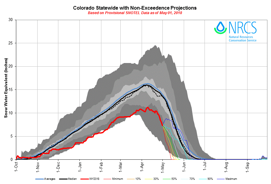
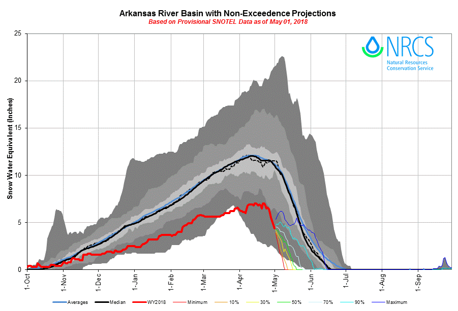
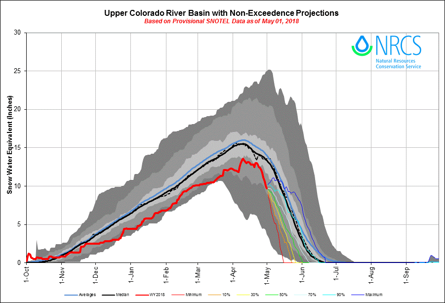
Since our last Update on April 25 dust layers have fully emerged at our Senator Beck Study Basin and all but the most unique locations (i.e. high elevation north facing nooks) throughout the San Juans. At Swamp Angel full emergence of D6-D7 occurred on April 27. There was a small separation of D6-D7 from D3-D5 as of April 29, but observations May 1 show all dust layers are now combined at the surface. Now too, D2 – which has been lurking 30” above the ground - is now only 4” below the surface. D3-D7 already make for a very dirty layer and D2 is no slouch either, once these layers merge the remaining 30” of snow at Swamp Angel, and by extension the Northern San Juan Mts, will see the worst dust conditions of the season (unless we receive more dust events) and rapid melt under sunny conditions. Judging by SWE ablation at SNOTEL sites across Colorado dust, and its severity as described in our April CODOS tour Update, is at the surface at all locations as well.
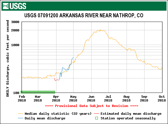
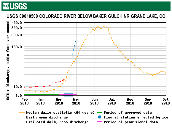
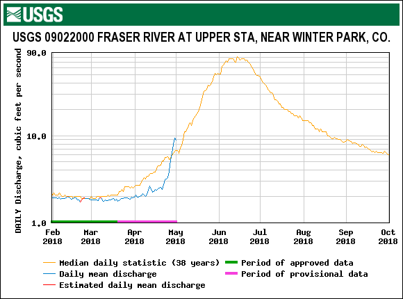
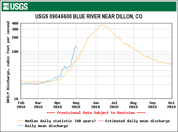
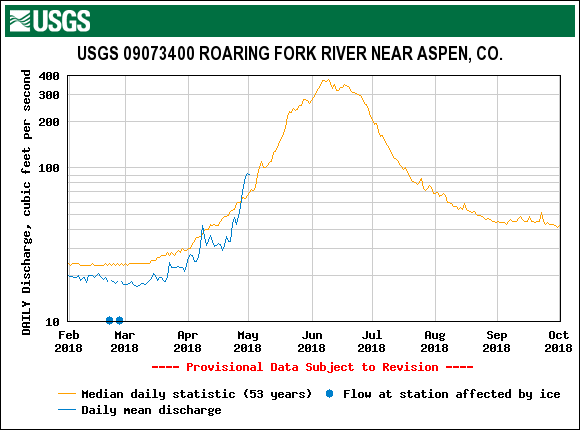
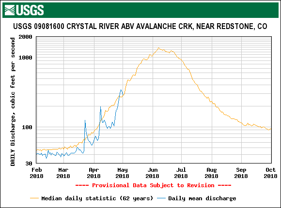
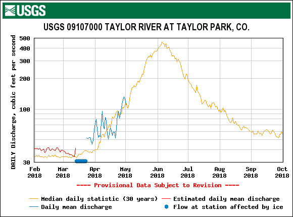
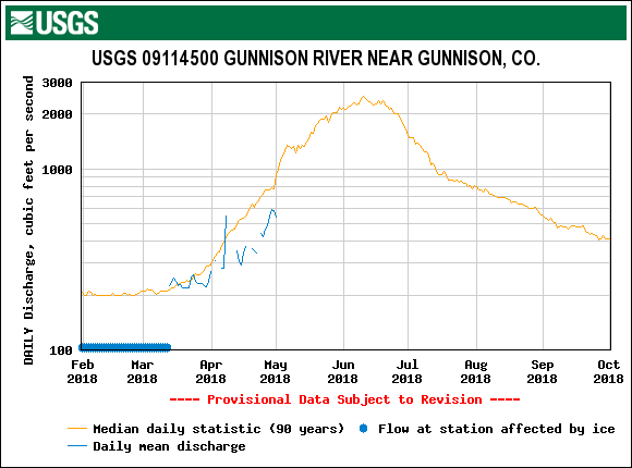
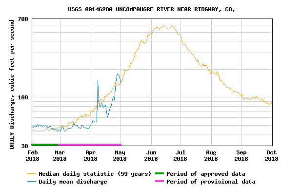
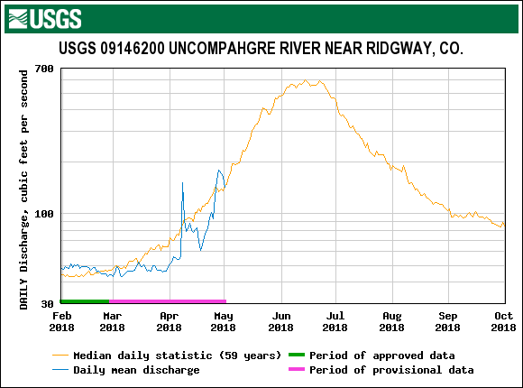
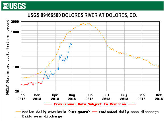
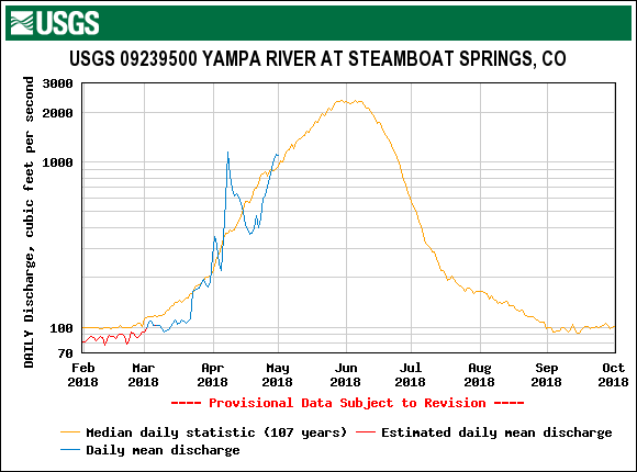
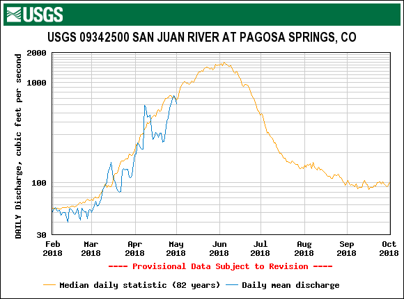
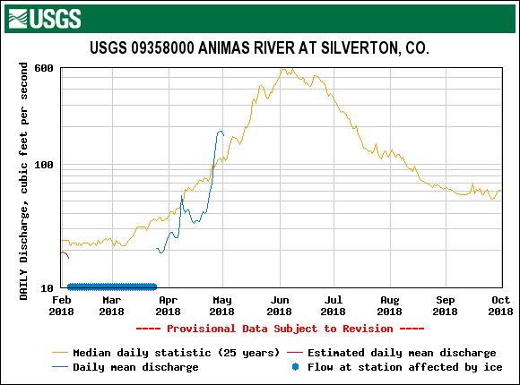
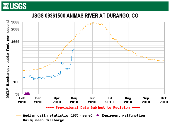
The steep rise in streamflow in response to the sunny/warm conditions and surfacing/exposed dust around much of Colorado over the last two weeks is slacking off a bit with the arrival of a series of Pacific Storms moving across Colorado today through Thursday. The forecast is calling for widespread precipitation across Colorado, hopefully it will fall mostly in the form of snow to cover existing dust and add to our snowpack reservoir. Judging by the forecast and what we have received so far at SASP (0.5" precipitation with 6" of snow accumulation), dust will stay covered for a number of days following the passing of this system.
No D8 Observed: We had high southwest winds accompanied with dust warnings in the source region on April 29-30. The sky appeared clear in the San Juan’s throughout the entire duration of the event but there were observations of dust in the air in some of the western valleys and there appeared to be some brown haze over some of Colorado’s central mountains. Prior to the wind event we cleared the snow down to a clean surface at SASP and did not observe any new dust following the event. If any new dust was deposited elsewhere in Colorado it is very likely indistinguishable from existing dust already at the surface.
May CODOS Tour: With the drastic differences in snowpack between Northern and Southern Colorado the CODOS team is going to split the timing of our visits. We will visit the San Juan, Grand Mesa, and Park Cone sites around May 7-9 hopefully to document the reemergence of dust to the surface following this current storm – and its impact on the remaining snowpack. We will visit the Northern and Front Range sites a few days later to assess dust impacts on this closer to normal snowpack regime.
Please see plots and below.

Albedo continued to degrade as dust merged to the surface this past week. Cloud cover and cooler temperatures, followed by fresh snow on the dust resulted in decreasing streamflows, Streamflow may increase with possible rain falling in watersheds. Overall, snow received in the Colorado high country will provide an albedo reset with a duration dependant on the amount of snow received and sunny/warm conditoins following this current storm system.

Average albedo from SASP and SBSP with snow depth and streamflow. We lost a good amount of snow depth and SWE this past week. Streamflow at our gauge responded with a sharp spike, as did many throughout Colorado.

Pictures taken of dust-on-snow rarely accurately show the severity of the dust. The clean snow in this picture is seen in the snow blocks.