
SUMMARY
Despite sub-par March/April/May total precipitation to-date over almost all CODOS sites, the month of May 2015 has been notably wet and stormy, as correctly anticipated by the NOAA Climate Prediction Center. With no additional dust-on-snow since event D3 (April 14/15), and frequent snowfalls since then, the minimal dust contained in the Colorado snowpack has remained generally well-buried under clean snow, and snow albedo levels have remained high. WY 2015 snowmelt runoff hydrographs have most closely resembled either spring 2007 or spring 2012 Dust Enhanced Runoff Classification patterns, to-date, despite some new behaviors and unusual conditions. This Update is supplemented by updated snowpack SWE plots and hydrographs posted to the specific webpages for these CODOS sites. (CODOS site webpage links are shown at the top of the CODOS Program home page, and on all site pages).
DUST-ON-SNOW CONDITIONS
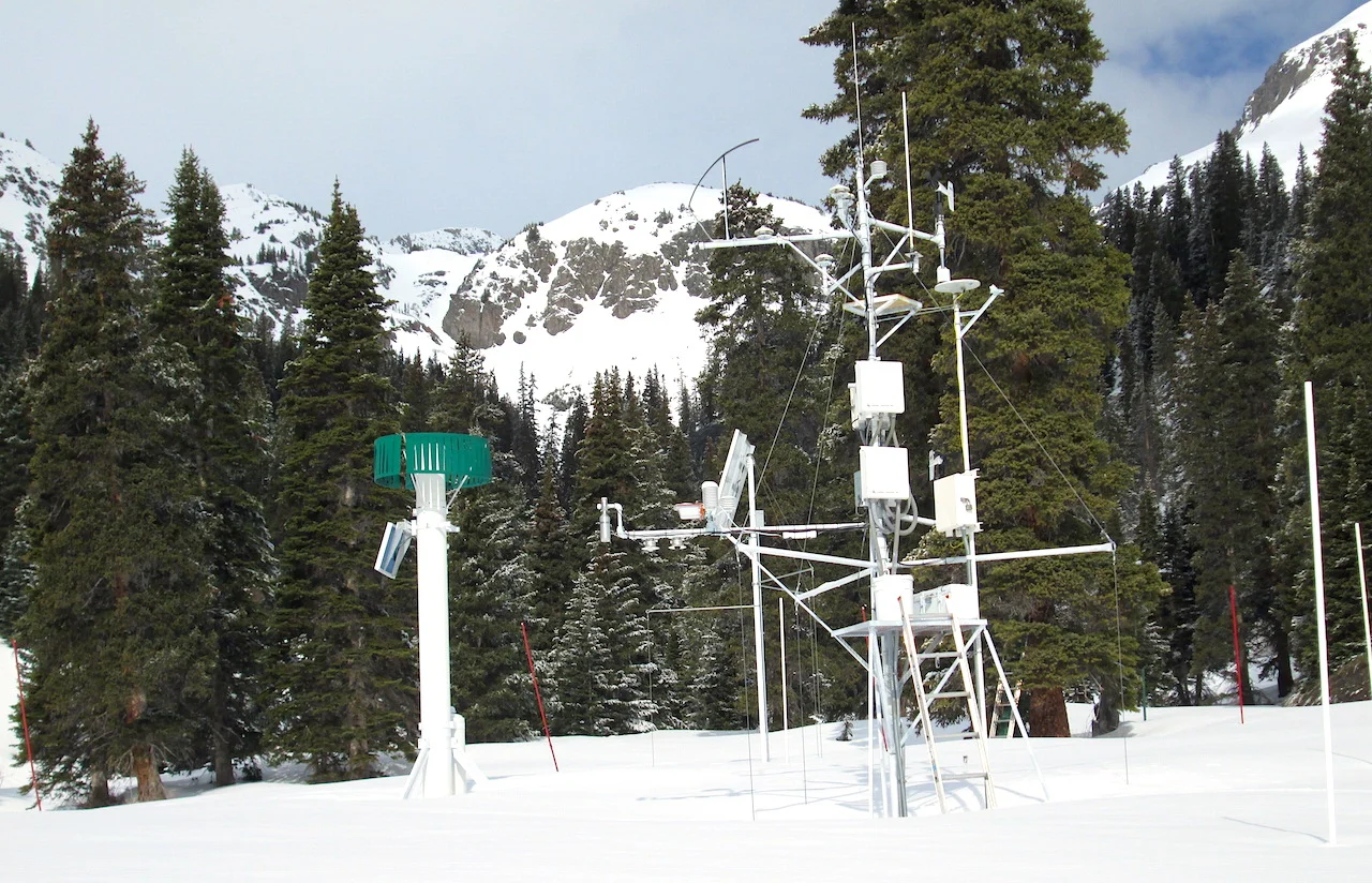
No new dust-on-snow events have been observed by the Center for Snow and Avalanche Studies and our CODOS program at the Senator Beck Basin (SBB) sentry site since the D3-WY2015 event of April 14/15 (see Dust Log). Based on mass analyses performed by our USGS collaborators in Denver of samples of events D1, D2, and D3, the total mass of mineral dust deposited to-date at the Swamp Angel Study Plot in SBB is just 2.048 grams per square meter (2 g/m2), a small fraction of the dust depositions observed by mid-May in prior seasons (see Mass Loading Data).
This decline in the number and intensity of dust-on-snow events, particularly during the March/April/May ‘dust season’, seems attributable to at least two factors. First, weather patterns this season have produced comparatively fewer synoptic scale weather events over the desert Southwest and Colorado Plateau with sufficiently potent S, SW, or W’ly pre-frontal wind fields capable of mobilizing, elevating, and transporting dust into Colorado. Overall, winter 2014/2015, through April, has been the least windy season in the period of record at the CSAS’s Putney Study Plot (PTSP). On average, April has been the windiest month at PTSP, but April 2015 was the least windy April in the period of record (see figure below).
A chart of total “miles of wind” at CSAS’s Senator Beck Basin Putney Study Plot, by month, for winters 2004/2005 through 2014/2015 (through April). The far right column presents mean data for the period of record.
Secondly, based on airport observations and modeled data for the Colorado Plateau region, it appears that the few weather events that did produce such wind fields were often preceded by or included sufficient snow and/or rain precipitation to greatly limit the availability of loose soils for mobilization. The CODOS program focuses its field monitoring activities and resources on the deposition of dust in the Colorado Mountains and does not have the resources to monitor dust emission conditions over the greater Colorado Plateau. However, CODOS does follow National Weather Service wind and precipitation data from airports at Winslow AZ, Cortez CO, and Blanding, UT, as well as NWS forecasts for several Colorado Plateau locales. We also monitor NASA MODIS imagery and USGS webcams at Abajo Peak, Mesa Verde, and in/near Canyonlands Park for photographic evidence of dust events in progress in the Colorado Plateau source area.
SNOWPACK & PRECIPITATION CONDITIONS
As seen in the basin scale plots of aggregated Snotel data below, and as CODOS program participants well know, all of the major watersheds in Colorado except the South Platte Basin experienced their maximum snowpack development in early or mid-March, 2015 and have generally declined, in some cases very sharply, ever since. Among the major basins, the Upper Rio Grande River Basin has certainly fared the worst.
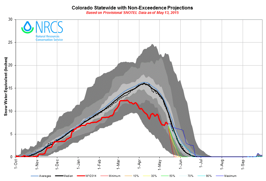
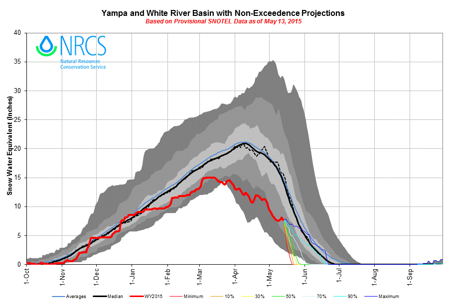
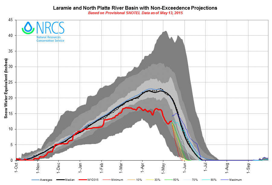
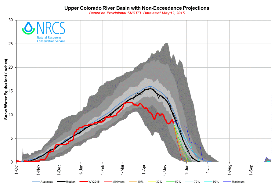
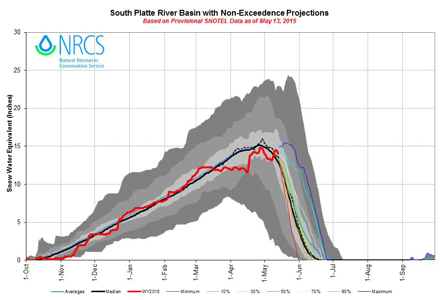
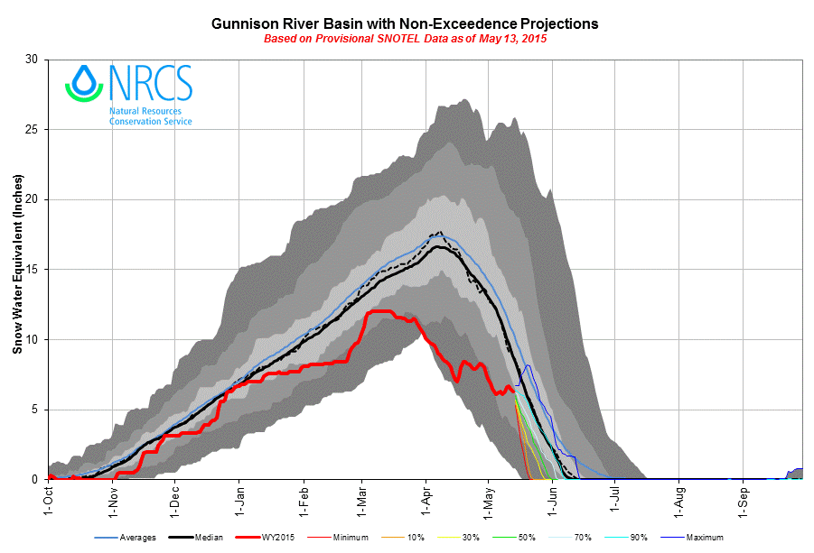
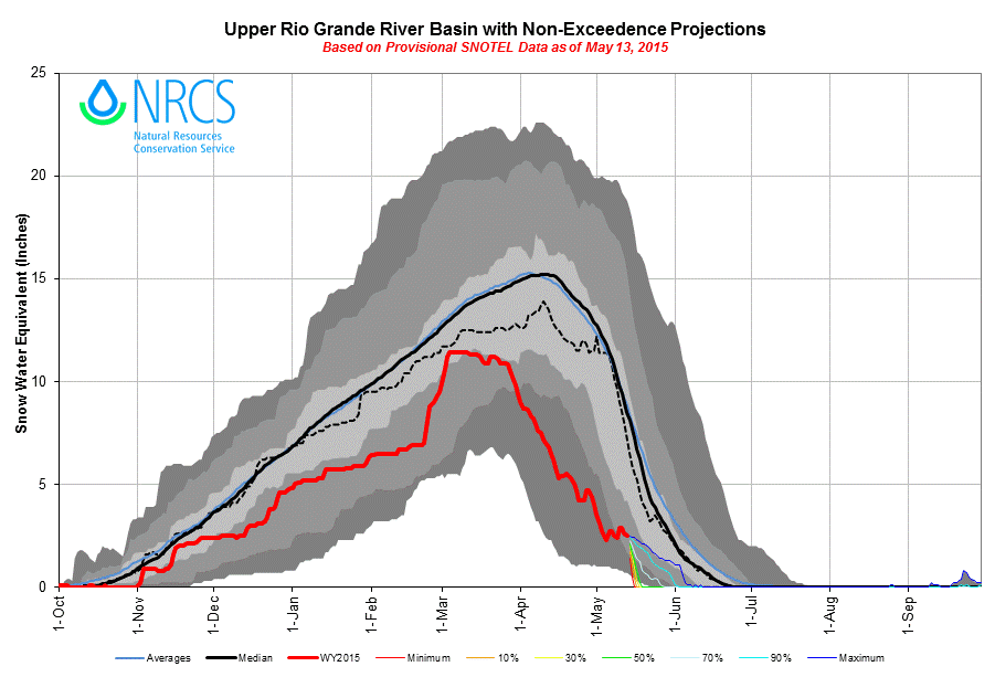
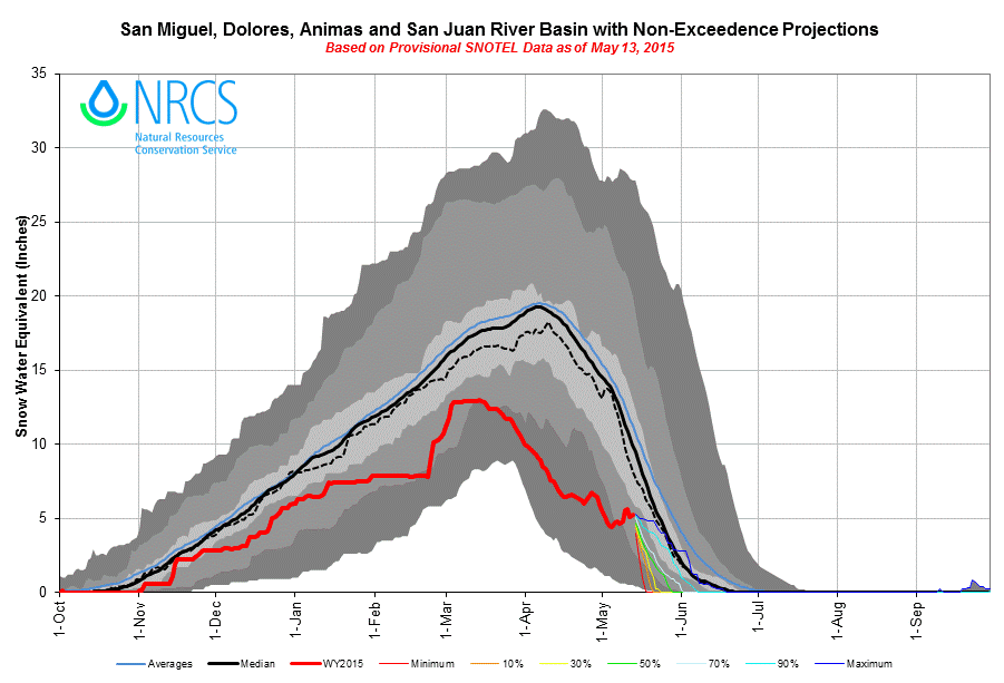
Overall, at the Snotel sites that CODOS most closely monitors, combined March, April, and May precipitation has fallen far short of average, to-date (see below). Under the CODOS Dust Enhanced Runoff Classification criteria for precipitation, only Hoosier Pass and Slumgullion Snotels would rank as AVG Spring precipitation at this point, with the second half of May yet to come; the remainder would fall into the DRY Spring category.
Combined March, April, and May precipitation, through May 15, 2015, has fallen well short of average for thirteen of these fifteen Snotel stations adjacent to or near CODOS monitoring sites. Only Hoosier Pass has experienced above-average precipitation.
Had Colorado experienced any dust-on-snow events during the very dry month of March, that dust would have experienced frequent and sustained exposure at the snow surface, reducing snow albedo, absorbing solar energy, and accelerating the snowmelt cycle. Fortunately, no dust fell in March. Three comparatively minor dust-on-snow events were deposited in early April but soon covered (where present at all) by clean snow and generally shielded from direct solar radiation in most locations. Even where that dust did emerge, reductions in snow albedo were comparatively minor. Snowpack ablation at CODOS Snotel sites has occasionally reached rates of 1.0” SWE loss per day but has not matched the rates of 1.5-2.0” SWE loss per day observed at those Snotels during periods of dust-enhanced snowmelt in prior, much dustier seasons.
Most recently, the first half of May 2015 has delivered considerable additional snow to the Colorado Mountains with several significant winter storms. Here in the western San Juan Mountains, May in Senator Beck Basin has produced precipitation on 15 of 17 days including three ‘numbered’ Winter Storms. Those three storms bring our Water Year 2015 Winter Storm count up to 16 and our Water Year precipitation total to 734 mm (28.9”). Our 11-year average through the month of May is 24.3 numbered Winter Storms containing 859 mm (33.8”) of water. Senator Beck Basin is still well short of our normal storm tally but is proportionally closer to our average precipitation thanks to large storms in early winter.
Interestingly, because of unusual, wind-affected snowpack formation in the alpine terrain of Senator Beck Basin, our most recent Winter Storm #16 (April 14-16) actually produced this season’s maximum snow depth at the Senator Beck Study Plot (12,180’) and perhaps our Peak SWE for the season as well (to be determined later this week). This additional May snow is contributing a substantial fraction of the total snowmelt yield from Senator Beck Basin. The same is occurring in many watersheds throughout the Colorado Mountains, somewhat mitigating the very poor snowpack conditions entering May.
In addition to enhancing the snowpack, these May snowfalls are preventing the exposure of the merged, if comparatively weak, D3/D2/D1 dust layer (or D3 alone, at many sites) and consequent reductions in snow albedo, however minor those reductions will eventually be. Instead, the Colorado mountain system is progressing through the month of May with high snow albedo values characteristic of clean, often new, spring snow. Solar (shortwave) and thermal (longwave) radiation are still providing a major share of the snowmelt energy budget but without the additional fraction of absorbed solar energy, by dust, that we’ve observed during periods of dust-reduced snow albedo in recent years. Thus, despite a DRY Spring (sub-par M/A/M total precipitation, to date), the Colorado snowmelt cycle has been prolonged by a complete absence of dust-on-snow in March and only MIN(imal) Dust loading to the Colorado snowpack in early April, subsequently buried under substantial amounts of clean snow from the subsequent storms of late April and this first half of May.
RUNOFF BEHAVIOR
Previous CODOS Updates have utilized a Dust Enhanced Runoff Classification (DERC) scheme to identify prior dust-enhanced runoff cycles observed during the program’s 2006-2014 period of record that could predictively approximate the general pattern of WY 2015 runoff hydrographs in numerous Colorado watersheds. Clearly, such a small set of cases is unlikely to capture the full range of variability in a natural process as complex as Colorado snowmelt. In fact, WY 2015 has exhibited a new set of conditions within and even outside the DERC scheme that are determining snowmelt runoff behavior this spring. These include early development of isothermal snowcover unrelated to dust effects, significant rain and rain-on-snow events, and (so far) still the most minimal dust loading observed to-date, with no additional events since D3 (April 14/15).
Nonetheless, comparisons of current WY 2015 hydrographs to 2012 and 2007 hydrographs, in the watersheds listed below, may provide useful insights into the remainder of the spring 2015 snowmelt runoff cycle. (See CODOS site webpages for updated hydrographs and for the complete DERC hydrograph database for these watersheds.)

WEATHER & CLIMATOLOGY
As of this writing, Monday, May 18, 2015, the National Weather Service Grand Junction and Denver offices expect another period of significant winter weather in the next 24-36 hours throughout the Colorado Mountains, with the heaviest snow accumulations in the Front Range. Unsettled weather for the remainder of the week may precede another wet and stormy weekend of May 23-24 for the mountains.
The NOAA Climate Prediction Center mid-range forecasts, for May 23-27 and for April 26-May 2, respectively, also indicate a tendency for wet weather for the remainder of May, but perhaps some drying (to near-normal precipitation) later in the month for the southwestern mountains.
CPC’s 6-10 day precipitation outlook as of May 17, 2015.
CPC’s 8-14 day precipitation outlook as of April 18, 2015.
Farther out, CPC’s three-month precipitation outlook (prepared on April 16 – no more recent product available) for June, July, and August continues to project increased probabilities of above normal precipitation for Colorado.
CPC’s three-month precipitation outlook for June, July, and August, as of April 16, 2015.
UPCOMING CODOS FIELDWORK
In the absence of any further dust-on-snow events in the meantime, a final circuit of CODOS sites will be conducted in late May or early June, perhaps in two stages. These site visits will be timed to collect as many samples of “all (dust) layers merged” samples at the snowpack surface as possible, and to observe this year’s dust deposition as widely exposed as possible.