
SUMMARY
Colorado has begun March with average conditions dominating the range of snowpack conditions among the major basins across the Colorado mountain system. This Update evaluates March 1st snow water equivalent (SWE) data from Snotel stations associated with our eleven CODOS sites and places them within the framework of the Dust Enhanced Runoff Classification scheme (DERC) developed by CODOS. This Update summarizes the state by Basin, and provides a site-specific analyses for each CODOS site (linked below).
Over the course of our 2005-2016 period of rigorous observations, March 1st has marked the beginning of the heart of “dust-on-snow season” for the Colorado mountains (see the CODOS Dust Log chart of dust events by month). So far for WY2016 at Senator Beck Basin, the primary ‘sentry site’ for the CODOS program, we have logged two dust events. The first dust event (D1-WY2016) was deposited with Winter Storm #6, December 11-12. This layer is located approximately 50 cm above the ground surface and will be the last layer to merge with the overlying layers during the snowcover ablation process. D2-WY2016 occurred late in the afternoon and evening of February 18. Eye witness reports indicate this event was wide spread and brought various amounts of dust to much of the Western Slope. Here at Senator Beck, this layer was mostly covered by Storm #14 on February 22, and currently sits approximately 7-10 cm below the snow surface.
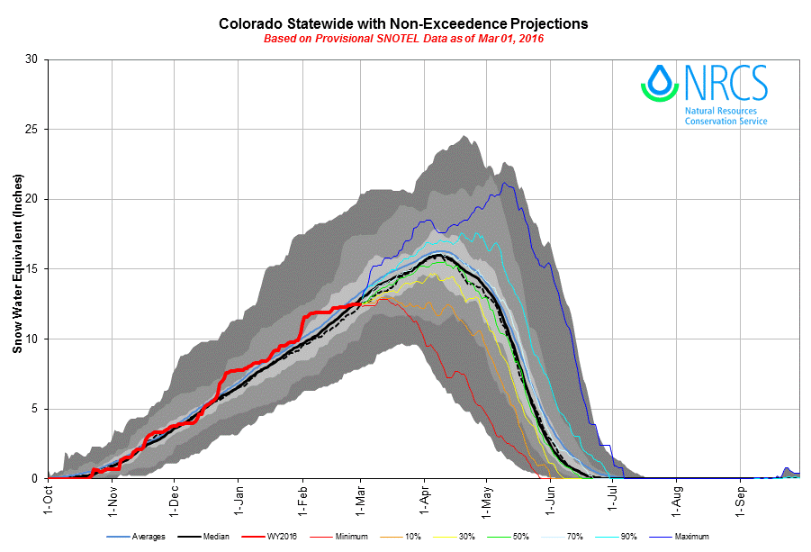
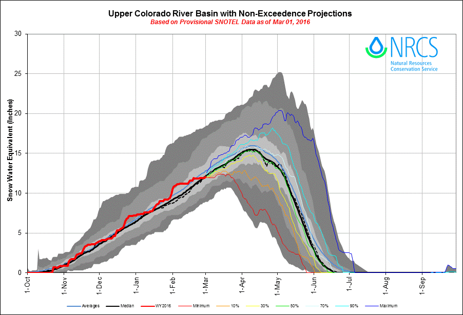
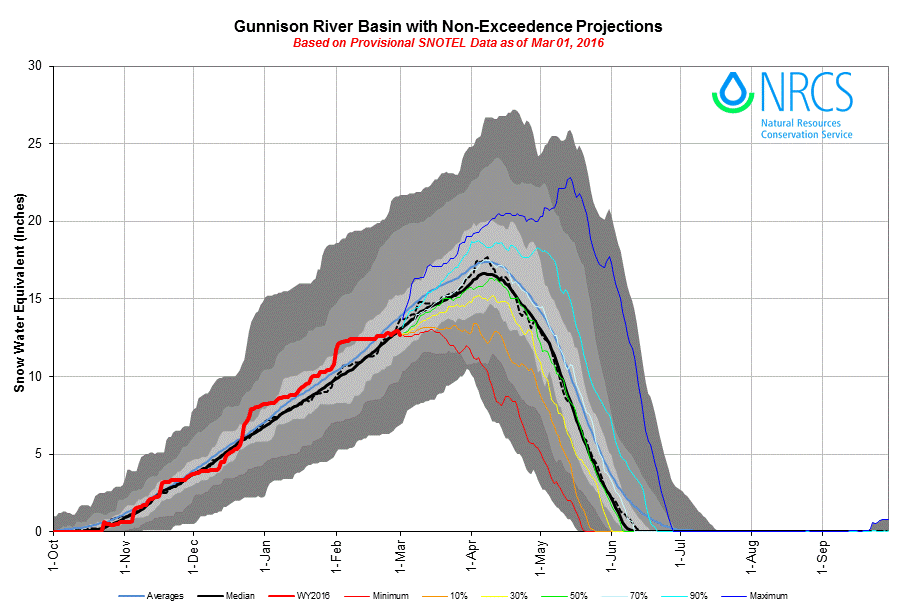
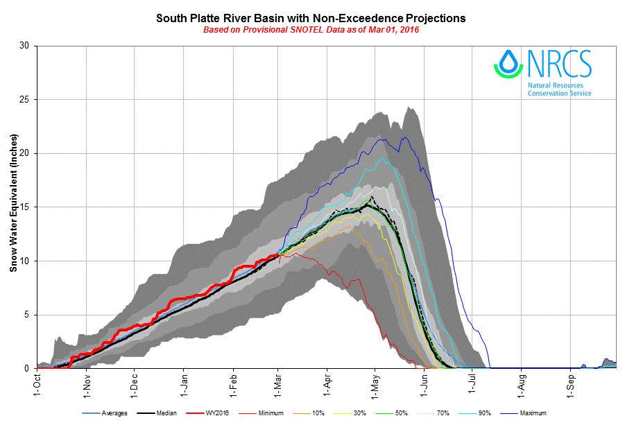
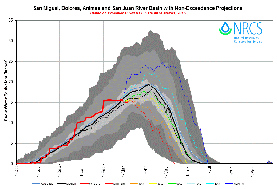
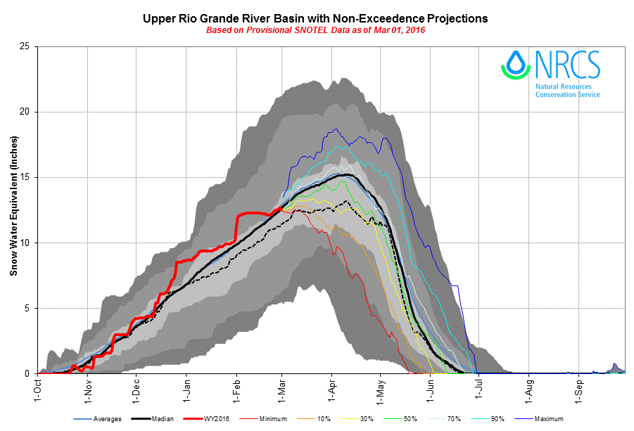
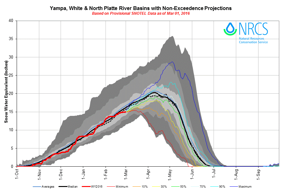
As of March 1st, Colorado SWE remains very near average among the major basins, with no basin reporting greater than +/- 10% deviation from 1981-2010 median levels. (DERC “Average” SWE equals day median +/- 10%). The basins listed below are classified according to the appropriate DERC classification of either Low, Avg, or High March 1st SWE layer domains.
As described in our January 21, 2015 Update, the DERC framework will be utilized to identify prior years with similar patterns of dust-on-snow intensity, March 1 SWE, and spring precipitation conditions, and their associated hydrographs. March 1st SWE analyses have been performed for each CODOS site, from this, hydrographs from 2006-2015 with associated March 1 SWE conditions have been identified and included in the analyses.
An ‘exploded view’ of the Dust Enhanced Runoff Space, separated by March 1 SWE classifications.
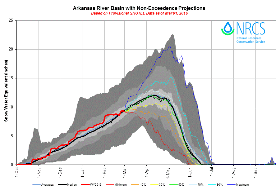
It now remains to be seen how WY 2016 dust conditions and spring precipitation evolve, and to further define the set of plausible hydrographs using prior season examples. The NRCS basin-scale SWE condition plots below use non-exceedence probabilities to project a range of future snowpack conditions, from the least likely (historical max and min traces) to the most probable (50% trace), based on the historic record. Statewide, NRCS indicates a nearly 50% non-exceedence probability of achieving a median snowpack. As they become available in early march, similar NRCS site-specific projection plots will be posted to each CODOS site’s web-page.
The NOAA Climate Prediction Center provides seasonal outlooks for March/April/May (MAM) precipitation and temperatures (below). The current M/A/M precipitation outlook, which is slightly improved from the January 25 update, suggests the weakening El Nino is still expected to bring a good chance of above average precipitation statewide. The three-month air temperature outlook predicts normal temperatures for the majority of Colorado, with slightly below normal temperatures in the south/southeast portion of the state.
CODOS SITE-SPECIFIC ANALYSES
For individual Snotel stations associated with our eleven CODOS sites, March 1st SWE ranges from 78% - 119% of median levels. March 1st SWE conditions were classified for the Snotel station directly associated with each CODOS site, and also for select nearby Snotel stations. Prior seasons with similar March 1st conditions were identified and placed within the appropriate dust enhanced March 1st SWE space. Local watershed hydrographs (from 2006-2015) associated with those March 1st SWE conditions are presented as plausible examples of runoff behavior in spring 2016, with the understanding that these prior years exhibit a limited variety of 2006-2015 dust and spring precipitation conditions for each CODOS site.
These analyses are presented in PDF format and are available for the watersheds listed below (in alphabetic order):
UPCOMING FIELDWORK
The CODOS team (consisting of former Director Chris Landry, current Director Jeff Derry, and Field Technician Andrew Temple) will perform the first circuit of the season of our ten CODOS sites (beyond Senator Beck Basin) sometime during mid-March, weather and dust conditions dependent. Snowcover temperatures, SWE, and dust presence/absence will be observed, along with basic snowpack structure, in full-depth snow profiles at each site.