
SUMMARY
The timing of our Colorado Dust-on-Snow (CODOS) fieldwork has been tricky with attempts to work around multiple storm systems, but during a complete circuit of all eleven CODOS program monitoring sites, from March 19-23, 2016, we documented a complete absence of dust-on-snow at the north and northeast monitoring locations, and dust within and/or on the surface of the snow at the remaining central and southern locations. However, on Tuesday, March 22, dust event #3 for WY2016 (D3) occurred during the latter portion of the trip, so it is possible these sites that were dust free prior to March 22, now have dust (as well as the other sites) near the surface of the snowpack. The morning after D3 occurred the CODOS team visited Wolf Creek Pass, Spring Creek Pass, and our Swamp Angel study plot and documented the severity of the event, findings are discussed below. Since March 1st, snow water equivalent (SWE) information from SNOTEL sites that we originally characterized as low or average in the Southern Basins has largely deteriorated, and we have also recorded isothermal or near isothermal snowpack temperatures at a couple CODOS locations. SNOTEL data indicate Northern Basins have seen an overall increase in SWE, based on percentage of median values. Current near-term weather products indicate a slight reduced precipitation probability compared to the mid-February forecast, likely since we are approaching summer and a transition to ENSO-neutral is likely during late Northern Hemisphere spring or early summer. Temperature probability forecasts have also evolved from normal/below normal to above normal over this same period. Still, the prediction of a greater chance of precipitation than normal suggest there remains the possibility of maintaining, or improving snowpack conditions close to median Peak SWE in most Colorado watersheds. WY2016 March 1st SWE conditions ranged from “Low” to “High” on the Dust Enhanced Runoff Classification (DERC) model and are now trending, as of late March, “Dry” to “Avg” for spring precipitation conditions within that March 1st SWE domain. This being an active period for dust-on-snow events, it is still too early to characterize dust conditions as being either “Min”, “Avg”, or “Max” for the winter season.
DUST CONDITIONS
We are now nearly a month into the March/April/May dust-on-snow season with a total of three dust-on-snow events having been observed so far at the Senator Beck Basin site at Red Mountain Pass, and dust was observed at half of our other ten CODOS sites during the March 19-23, 2016 circuit. Typically the San Juan Mountains receive 8-9 dust-on-snow events a winter, based on observations going back to 2005. Storm opportunities are also dust opportunities, and the Senator Beck sentry site is starting to fall behind on storm counts (defined as greater than 12 mm of precipitation with no break in precipitation greater than 12 hours). By this point in the season the average storm events having occurred is 19 (see graph below). That said, after the storm on March 23 we are now at Storm #16, and as of this writing Saturday morning, March 26, we are now receiving Storm #17. Five of the now 17 storms have occurred in the last 2-months. Near-term forecasts call for a greater than average chance of precipitation (see forecast discussion below) and this implies, coupled with the necessary soil, weather, and wind conditions, an increased chance of more dust-on-snow events for Colorado from SW’ly wind fields over the Southern Colorado Plateau.
SNOWPACK PROFILES
Full-depth snow profiles were performed at all eleven CODOS sites from March 19-23, documenting the presence/absence of dust-on-snow. Measurements including SWE, snow depth, and mean (bulk) density of the snowpack at these CODOS sites also assist with verification of conditions as reported by their nearby SNOTEL stations. A brief statement of snowpack and dust conditions at each CODOS site is provided below.
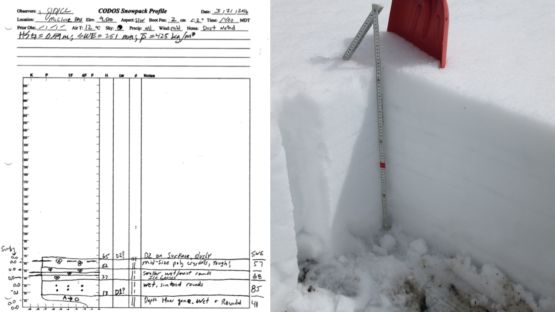
These profiles also document the remaining cold content of the snowpack as spring approaches. One CODOS site (McClure Pass) has an isothermal snowpack at 0.0° C throughout, and another (Wolf Creek Pass) is very near isothermal (see table below). March 2016 snowpack temperatures are very similar to March 2014 conditions, albeit 2016 data was collected approximately a week earlier than in 2014. However, this is still a vast improvement compared to conditions in March 2015 when all sites were isothermal or near isothermal by this time.
Snow that has become isothermal (or is close to it) is unlikely to cool significantly, except diurnally, and then only in near-surface layers under overnight radiant cooling to clear skies. New snow layers typically insulate the warm snow they land on from overnight cooling and are subsequently warmed quickly by both the heat content in the underlying snow and by normal surface energy inputs. This said, it is possible to temporarily delay further warming depending on new snow accumulation and weather conditions.
Mean measured snow temperatures, by CODOS site, in March 2016, March 2015, March 2014, and March 2013 snowpack profiles, as measured at 10 cm (4”) intervals from the ground up. March 2016 snow profiles have retained significant cold content, very much similar to March 2014. The March 2013 snowpack retained still more cold content. In March 2015 most sites were at or very near isothermal temperature of 0.0° C.
Snowpack Summary
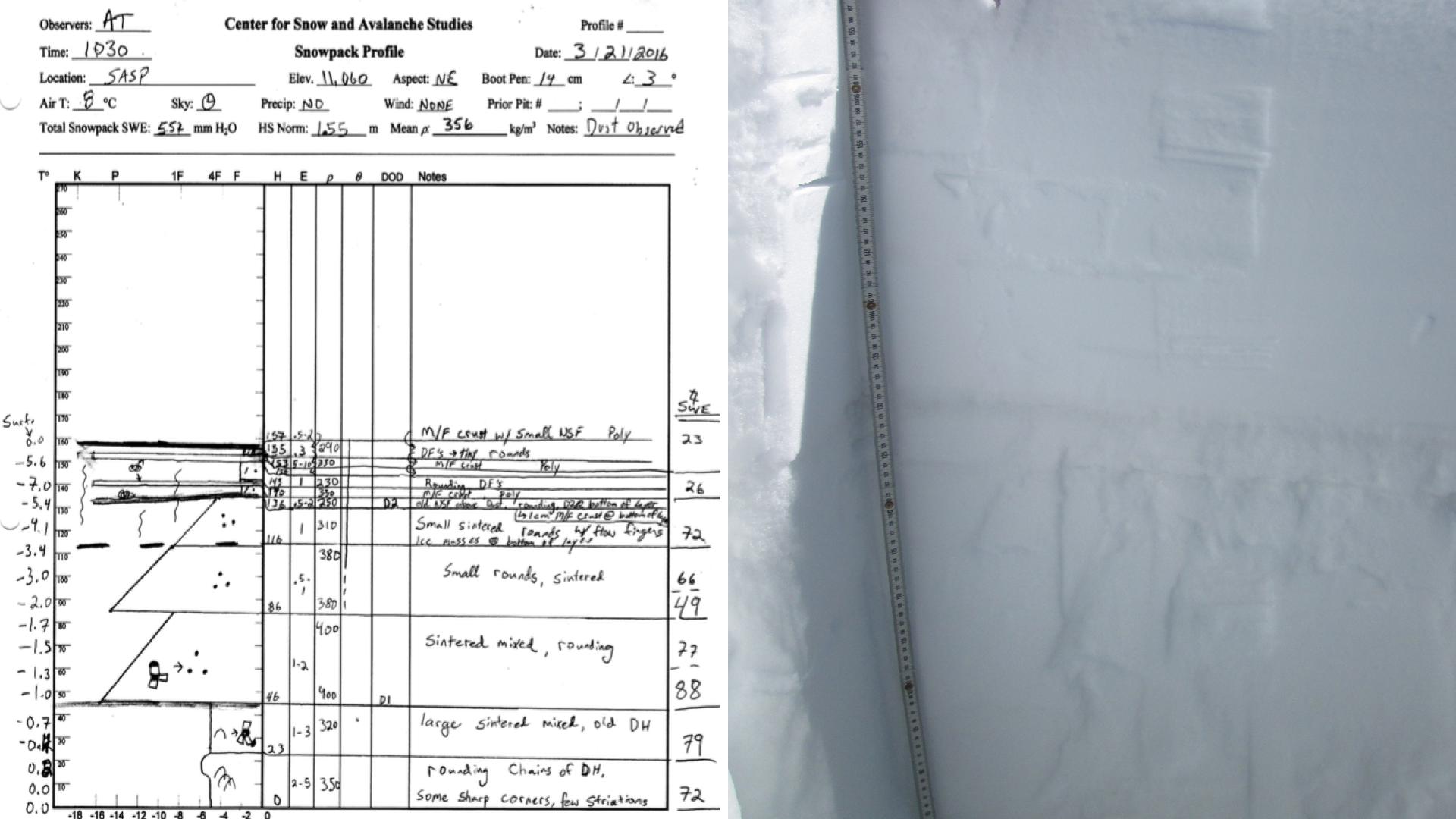
Swamp Angel: SWE = 20.5” (552 mm), Snow Depth = 5.1’ (1.55 m). Dust observed. D3, a mild event which happened March 22-23, is located 13’ (33 cm) beneath new snow accumulation. D2 is located 8.3” (21 cm) below D3. Molas Pass received very little of the March 22-23 snow totals that Red Mt Pass was fortunate to receive. From Silverton to Durango, D3/D2 is partially to completely exposed. The current March 26 storm is expected to favor the southern mountains, and presently Molas Pass has now received ~6” of new snow.
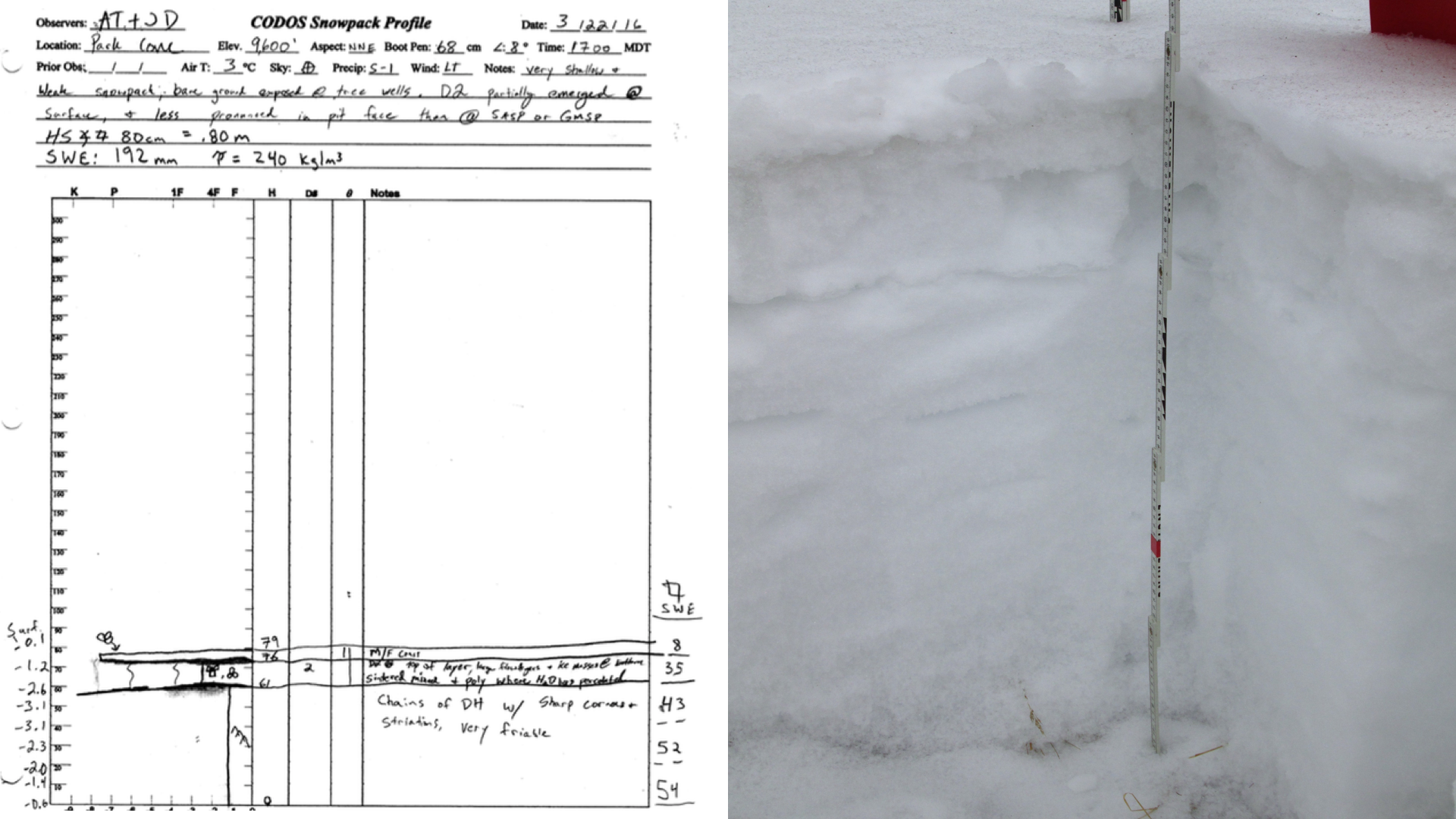
Park Cone: SWE = 7.6” (192 mm), Snow Depth = 2.6’ (0.80 m). Dust observed. As of March 22, D2 partially emerged at surface and bare ground is exposed at tree wells. D2 less pronounced in pit face than Swamp Angel or Grand Mesa. Field observers report D3 was received the evening of March 22 in the Crested Butte area, followed by a few inches of snow.
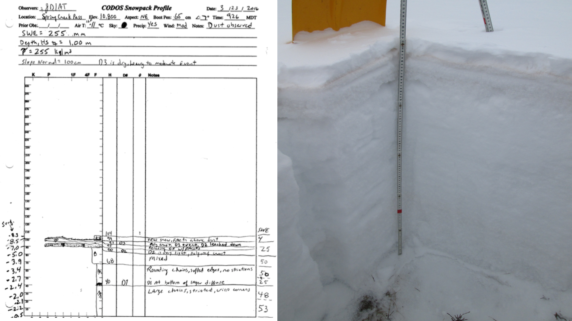
Spring Creek Pass: SWE = 10” (255 mm), Snow Depth = 3.3’ (1.0 m). Dust observed. As of March 23, D3 was observed 2”-2.75” (5-7 cm) below the surface. D3 was a very prominent, heavy to moderate event followed by snowfall. D2 is 2.75” (7 cm) below D3. High winds were observed to scour new snowfall, keeping D3 exposed in some areas, and creating dust dunes. Partial/thin snowcover toward lower elevations and very little or no snowcover in valleys to the south of Spring Creek.
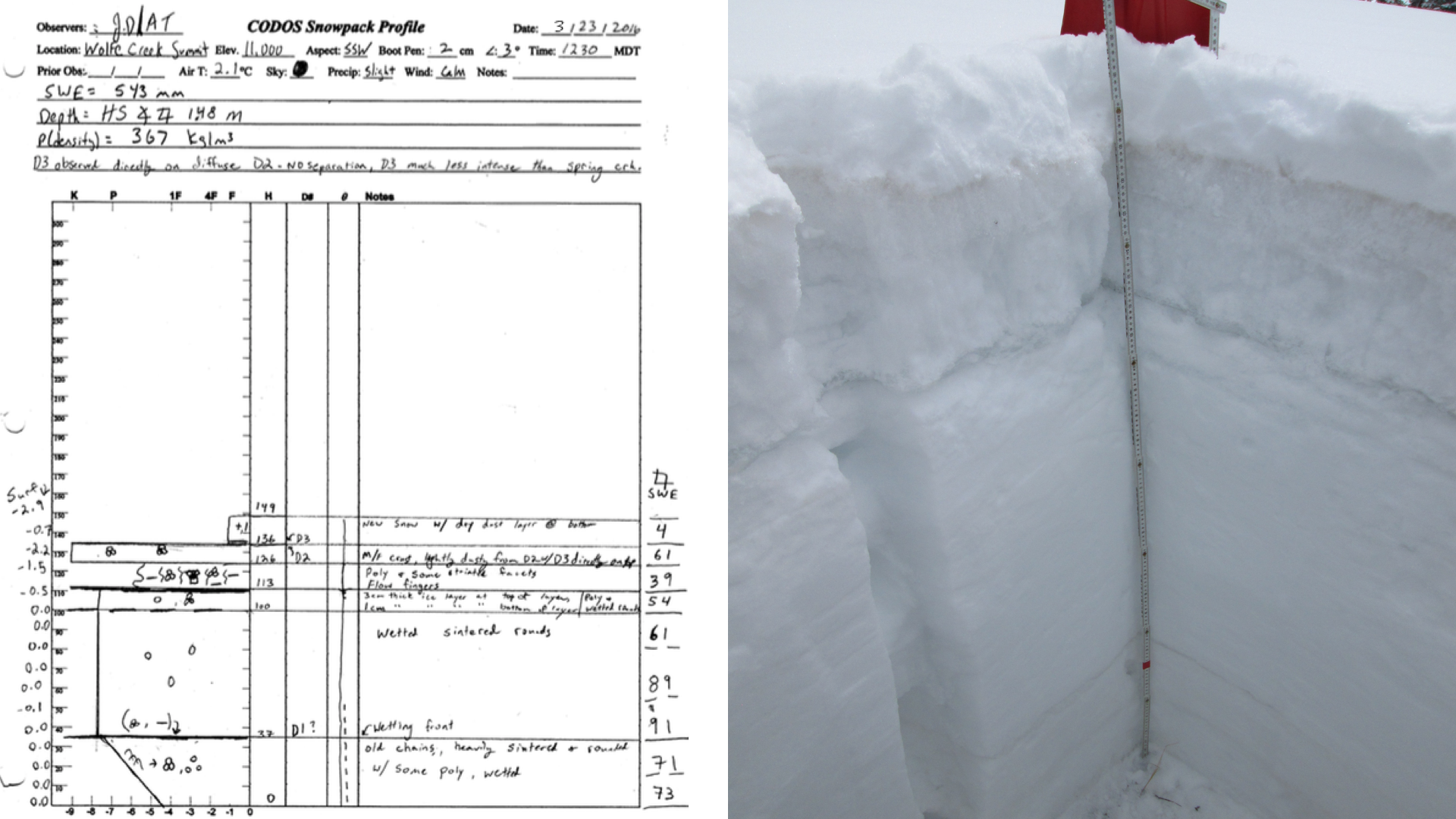
Wolf Creek Pass: SWE = 21.4” (543 mm), Snow Depth = 4.9’ (1.48 m). Snowpack very near isothermal. Dust observed. As of March 23, D3 was observed as being less prominent than at Spring Creek, but more severe than Swamp Angel. D3 is directly on diffuse D2 layer. Crust containing D3 and D2 is located approximately 5” (13 cm) below fresh snow accumulation.
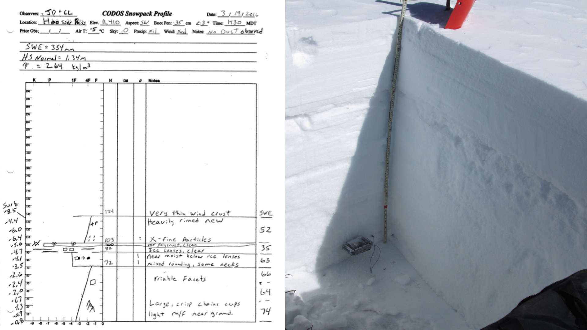
Hoosier Pass: SWE = 14” (354 mm), Snow Depth = 4.4’ (1.34 m). No dust observed. South Park free of snowcover. Surrounding peaks near Hoosier Pass show partial snowcover, scoured ridges, southern slopes mostly exposed.
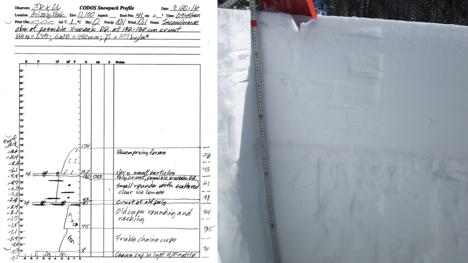
Loveland Pass: SWE = 18.9” (480 mm), Snow Depth = 5.7’ (1.74 m). Inconclusive observation of dust, possible very weak D2 at 17.3” (44 cm) below snow surface. Loveland Pass completely snow covered.
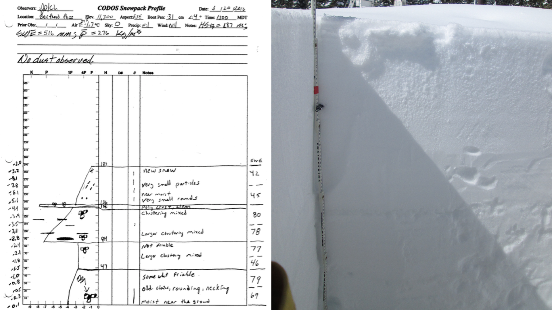
Berthoud Pass: SWE = 20.3” (516 mm), Snow Depth = 6.2’ (1.87 m). No dust observed.
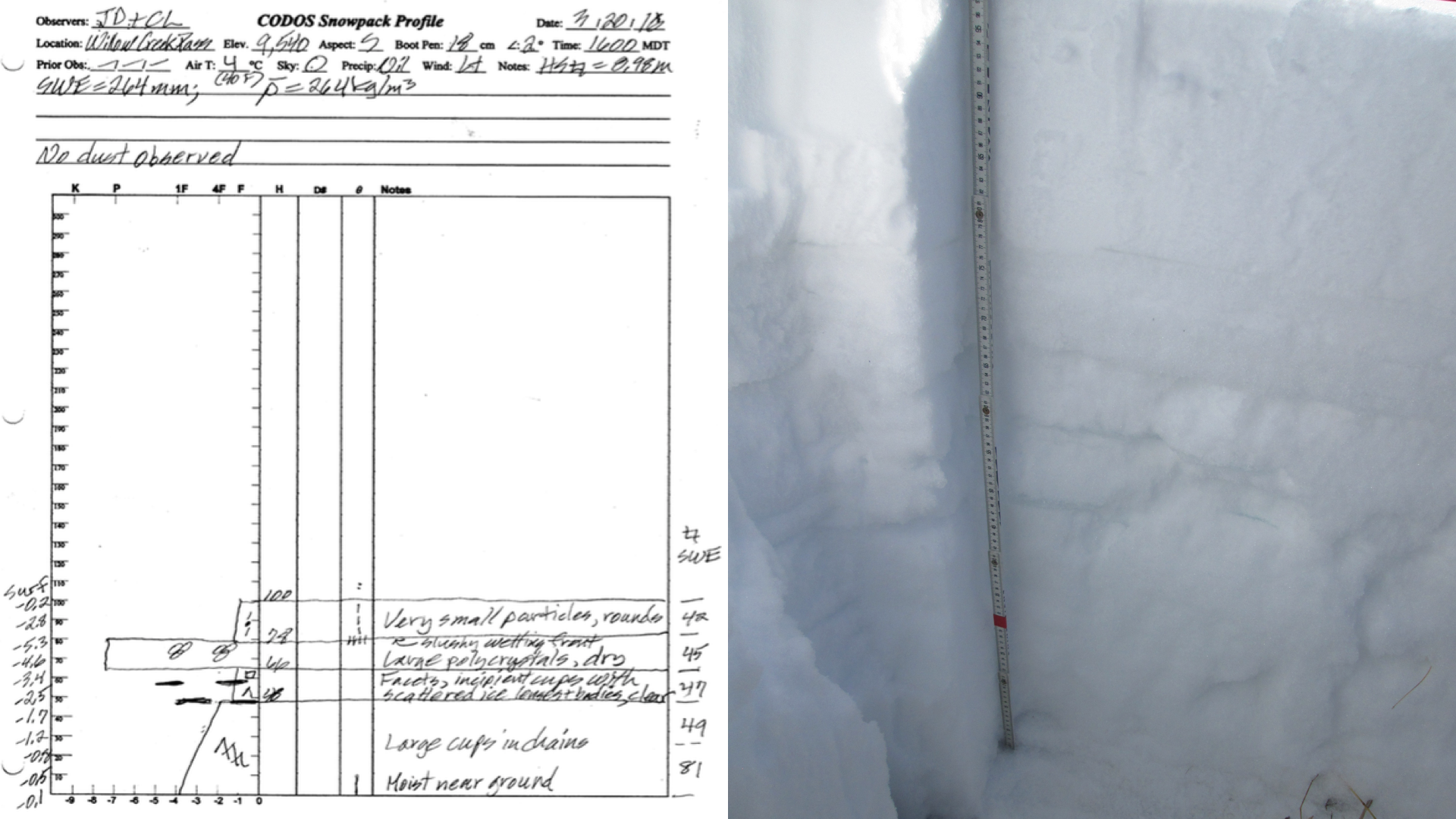
Willow Creek Pass: SWE = 10.4” (264 mm), Snow Depth = 3.3’ (1.0 m). No dust observed. Surrounding peaks snow covered, North Park mostly/completely snow covered.
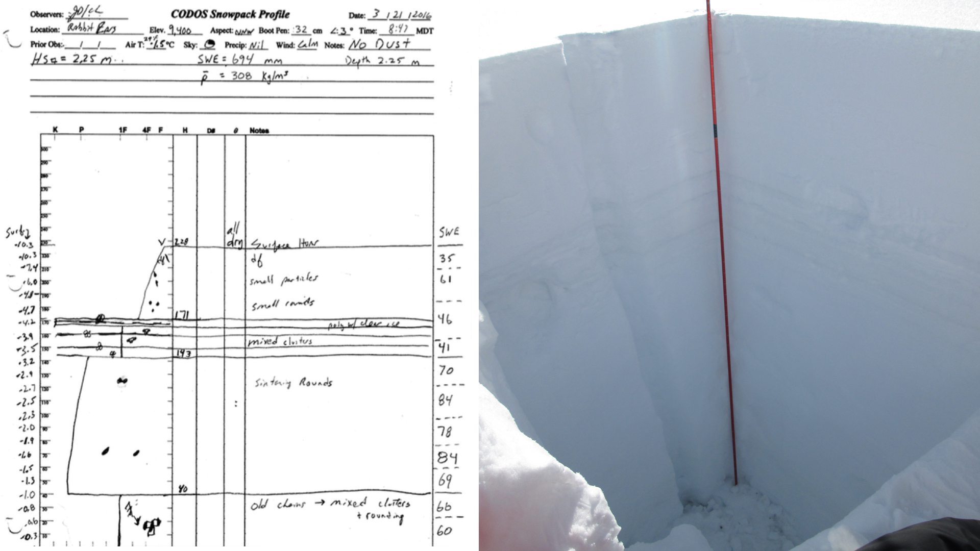
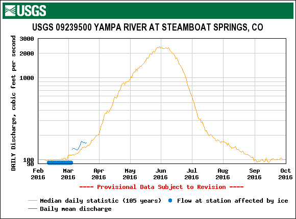
Rabbit Ears Pass: SWE = 27.3” (694 mm), Snow Depth = 7.5’ (2.28 m). No dust observed.
McClure Pass: SWE = 10” (251 mm), Snow Depth = 2.1’ (0.65 m). Snowpack isothermal. Dust observed. D2 on surface of snowpack. Possible D1 located at 6.7” (17 cm) above ground surface. Snow cover depletes quickly with elevation towards Paonia.
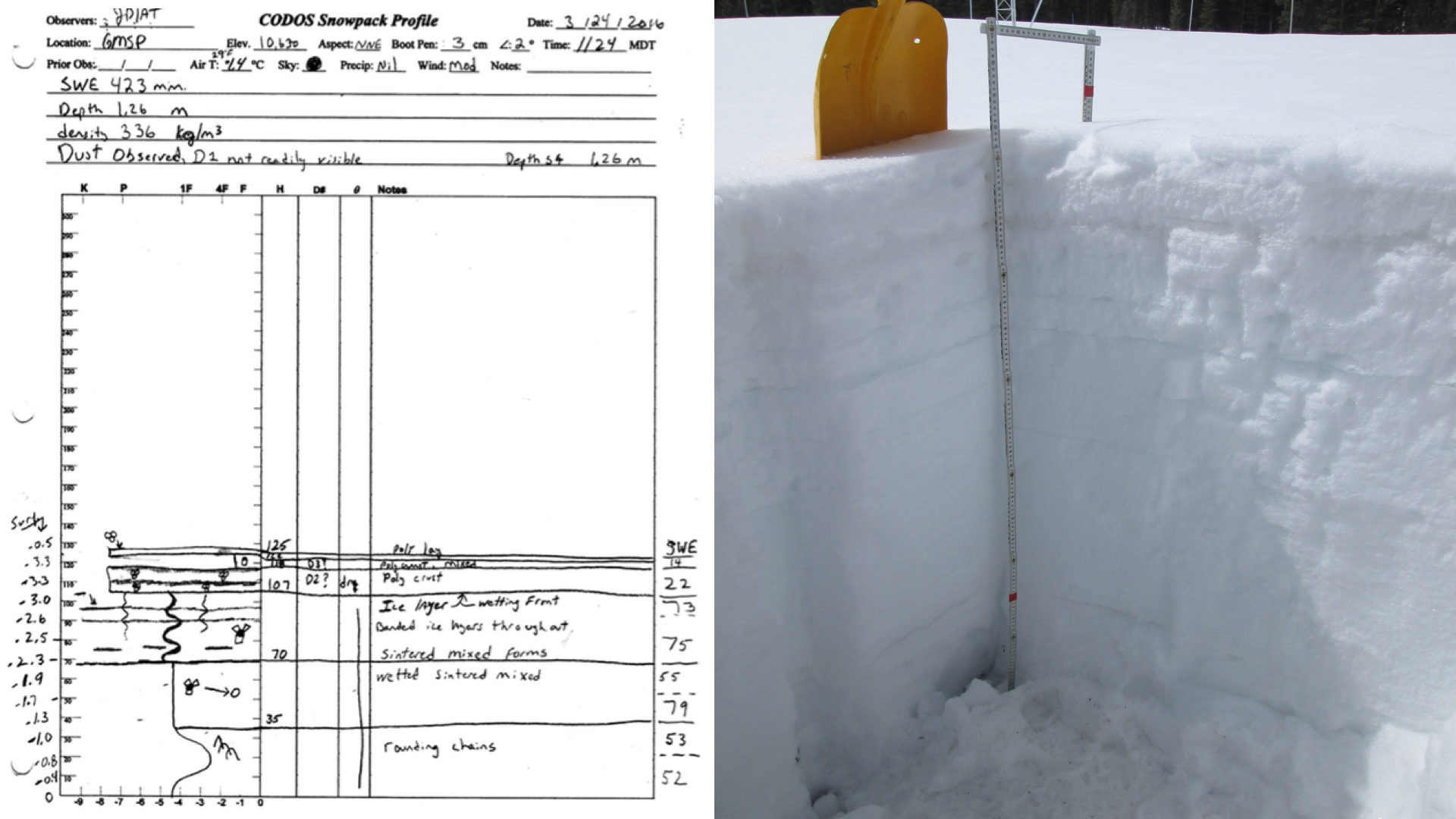
Grand Mesa: SWE = 16.6” (423 mm), Snow Depth = 4.1’ (1.26 m). Dust observed. A weak D2 layer located 7” (18 cm) beneath surface on crust. Also, possible weak additional layer not seen at other sites (D2-a) located 2.8’ (7 cm) beneath surface on crust.
SWE CONDITIONS
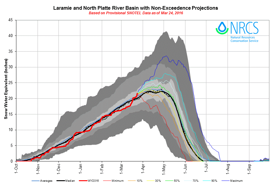
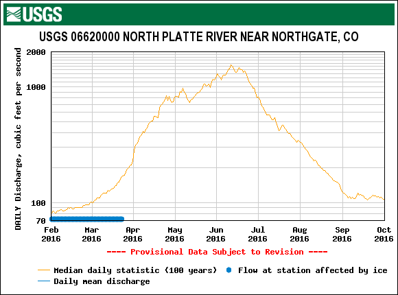
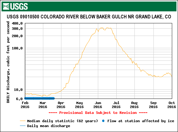
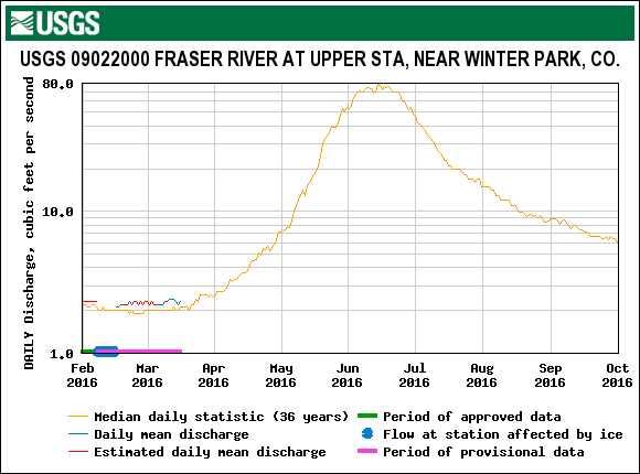
In the last 2-months, the consistent stream of storms received in the Senator Beck Basin prior to February has dissipated. And, since the March 1st CODOS update, SNOTEL sites throughout Colorado have begun to show an overall split. Basins located in Southern Colorado (Gunnison, Arkansas, Rio Grande, and San Miguel/Dolores/Animas/San Juan River Basins) have undergone a reduction in percent median SWE values. Basins in Northern Colorado (Upper Colorado, Yampa, South and North Platte River Basins) have seen an increase in percent of Basin median values (see table below).
The basin-scale SWE plots shown below aggregate all SNOTEL sites within their respective watersheds and project the non-exceedance probabilities of future snowpack formation and ablation in those basins, based on historic data. Similar projection plots, captured the day of our recent visit, are presented on CODOS site webpages for the SNOTEL stations associated with those sites.
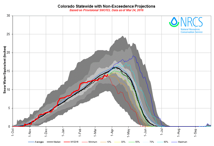
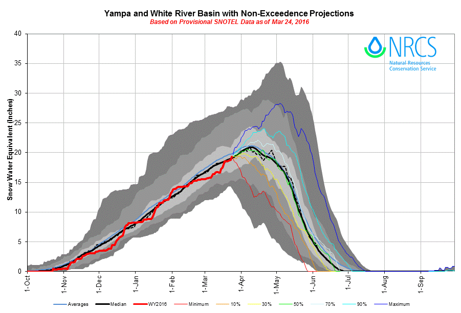
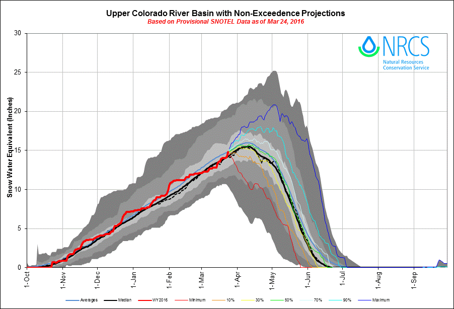
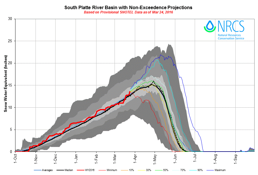
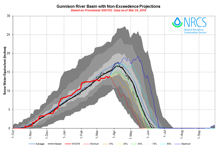
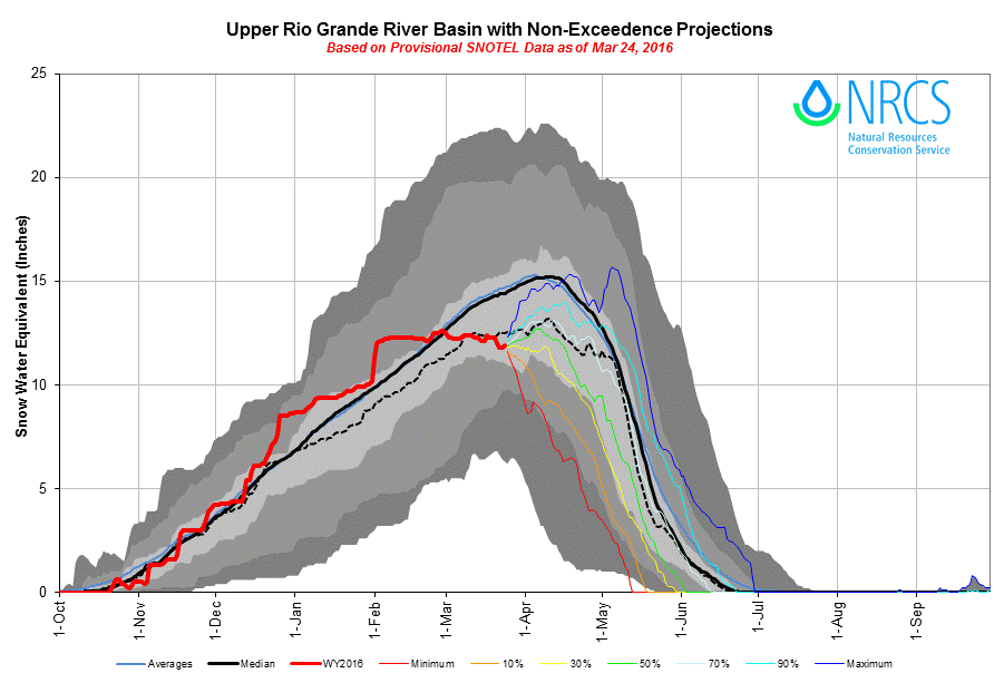
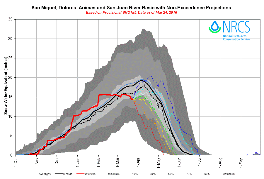
Not surprisingly based on the Basin SWE reductions, ten of the sixteen selected CODOS and SNOTEL sites have seen a decrease from their respective March 1st median SWE that was reported in the CODOS Update – March 1, 2016. Besides Independent Pass SNOTEL which is located in the lower central portion of the Upper Colorado River Basin, these reductions are seen in the Gunnison, Upper Rio Grande, and San Juan River Basins. Four of the 16 SNOTEL sites report an increase of percent of median SWE, and these sites are located solely in the Upper Colorado and Yampa/White River Basins. These trends can also be seen in the above NRCS SWE plots as well as the below chart comparing March 25th with March 1st SWE.
As these sites approach their typical date of Peak SWE, it is possible that some sites will have already experienced Peak SWE, should the current dry weather and early snowmelt ablation continue. Even if precipitation resumes, non-exceedence projection plots suggest that it is increasingly unlikely that Gunnison, Upper Rio Grande, and San Juan River Basins will achieve median Peak SWE. It is worth noting that these Basins also have very little or non-existent snowcover at lower elevations and valleys.
STREAMFLOW

Since the first part of February a lack of storm events, or large precipitation events in Southern Colorado, have begun taking its toll on the snowpack in the southern half of the state. With D2/D3 located near (Spring Creek, Park Cone, Wolf Creek, Grand Mesa) or at (McClure Pass) the surface of the snowpack in the southern regions, reductions in albedo, accelerated snowpack ripening, and resultant snowmelt could begin earlier than otherwise, if not buried or remain buried by spring snow accumulation. D2/D3 may increase absorption of solar radiation, accelerating the warming of the snow to isothermal. Once the snowpack is “ripe” for snowmelt discharge, then converting energy inputs from solar and thermal radiation, warm air, and possibly rain, will directly feed into snowmelt and runoff. For the time being, Northern Colorado’s average or above average snowpack, with its high albedo snowcover will slow the warming and eventual snowpack ripening, delaying snowmelt runoff.
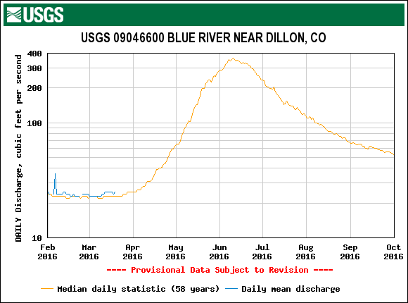
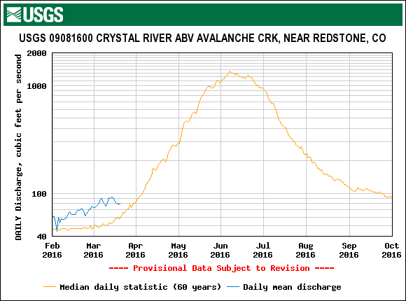
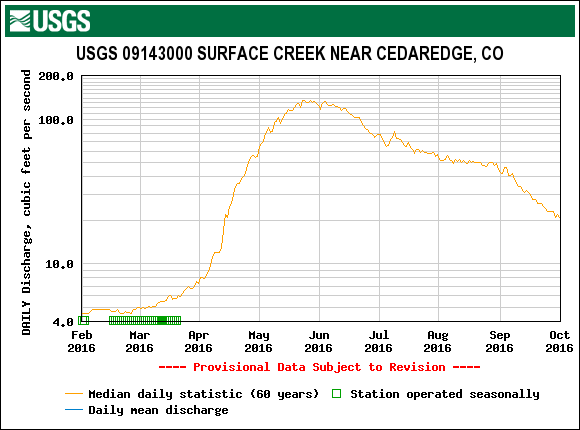
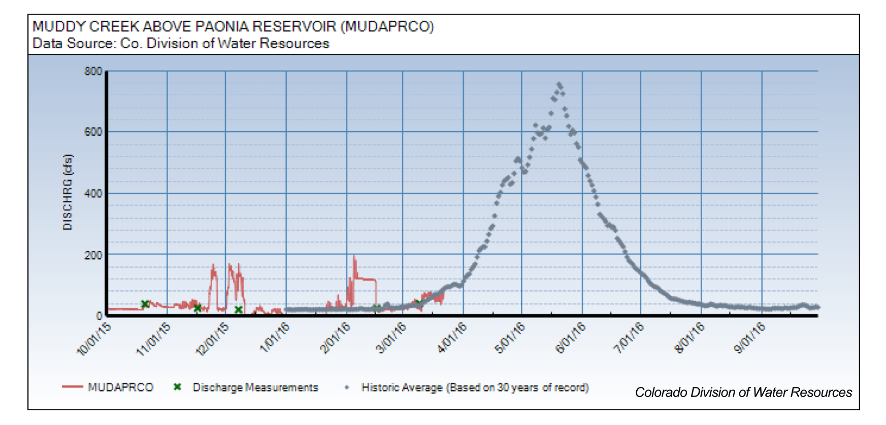
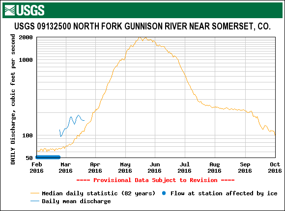
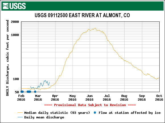
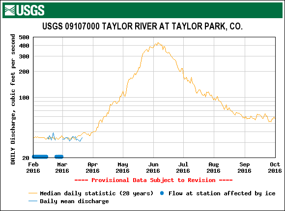
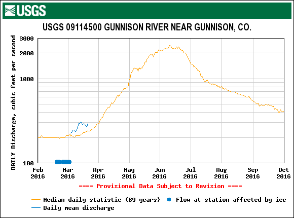
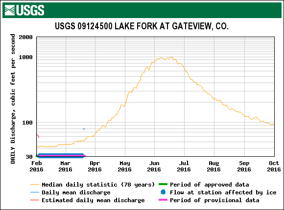
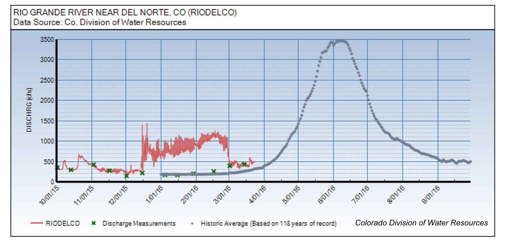
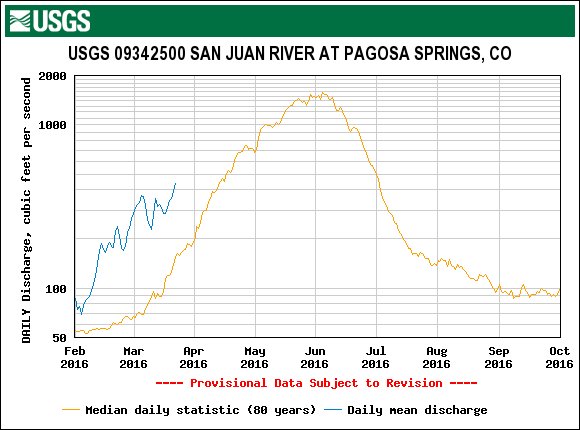
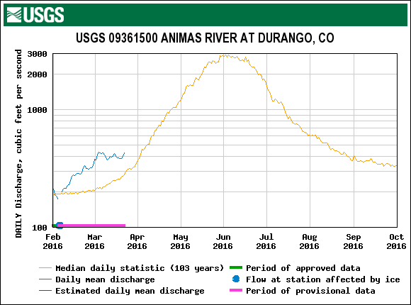
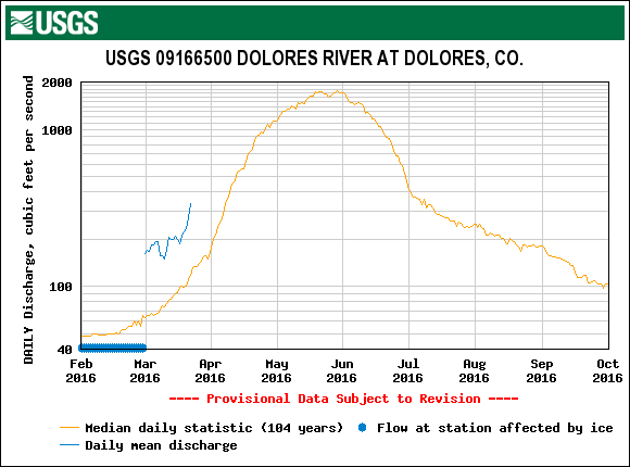
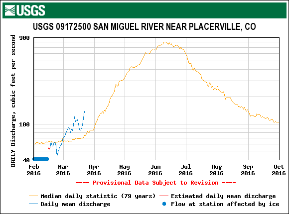
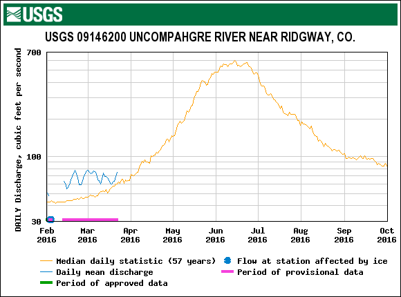
Stream gauges (where gauges are de-iced) located in the Basins with dust and/or reduced snowcover show flows above their respective March median levels. Crystal River near Redstone, North Fork Gunnison River near Somerset, East River at Almont, Rio Grande near Del Norte, San Juan River at Pagosa Springs, Animas R. at Durango, Dolores River at Dolores, San Miguel near Placerville, Uncompahgre near Ridgeway, are all showing discharge above median levels (see streamflow plots above). Muddy Creek, associated with the McClure Pass SNOTEL and co-located CODOS site, has yet to see a surge in discharge due to snowpack isothermal conditions and D2 being located on the snow surface.
WEATHER AND CLIMATE FORECASTS
The NOAA Climate Prediction Center has issued, as of March 17, 2016, new three-month outlooks for April/May/June precipitation and temperature (above). Forecast products, although still predicting an increased chance of precipitation, indicate a slightly reduced precipitation probability compared to the mid-February forecast. Last month the prediction was precipitation had a better than even chance of being above normal over a 3-month (March/April/May) period by 50%, that prediction is now 40% for April/May/June. Forecasters predict a transition to ENSO-neutral is likely during late Northern Hemisphere spring or early summer. Temperature probability forecasts have also evolved from normal/below normal to above normal over the same three-month period. The one-month outlook looks very similar to the three-month outlook (not shown), increased probability of above normal air temperatures, and increased probability of precipitation. CPC’s Seasonal Drought Outlook (below) for March 17-June 30 indicates Colorado as well as the Colorado Plateau (and dust source areas) will remain drought free.
DUST ENHANCED RUNOFF CLASSIFICATION
In our March 1st SWE Update we used the DERC model for WY2016 to classify watersheds by either “Low”, “Avg”, or “High” March 1 SWE domains. Since then, March has fallen short of improving “low” classifications or even maintaining “Avg” classifications in Southern Basins, but it has improved “Avg” conditions in Northern Basins. The climate forecast persists in forecasting above-normal precipitation for the remainder of spring, which, if played out to be the case, would go a long way in helping some Basins recover from a dry February and March.
With three dust-on-snow events so far this season, it is still too soon to attempt to classify dust events as either “Min”, “Avg”, or “Max” Dust. Previous years (2006 and 2007) that received dust during similar time-frames as WY2016, both ended the winter with 8 total dust-on-snow events. Compared to last winter, which saw a total three dust-on-snow events with a total mass loading of 2.1 g/m², WY2016 has already received at least double this amount of mass loading (4.1 g/m² without including D3). Dust intensity at Senator Beck is typically stronger than observed at sites farther downwind to the north and east. Dust characterizations at CODOS locations are tied to site specific conditions as well as conditions observed at Senator Beck. Judging by the current dust and snowpack conditions around the state, it is possible dust and SWE classifications will vary greatly in the DERC model, depending on site specific scenarios. CODOS will identify prior season hydrographs that best compare to current conditions as dust and spring precipitation conditions unfold.