

Summary
The majority of the April CODOS tour was accomplished just prior to the very significant closed low pressure system that set up over the four corners region and deposited at least 1” of precipitation at most CODOS sites across the state. The bulk of this storm occurred Friday, April 15 through Sunday, April 17. This spring storm brought high winds ahead of, and with, the precipitation, but as of this writing it appears dust did not accompany the storm. The Hoosier Pass site was visited late in the day on Friday, April 15 and the intense snowfall, snow packed roads, and chaotic traffic conditions prevented us from continuing on and visiting the last two locations on our April CODOS tour, Grizzly Peak (Loveland Pass) and Berthoud Pass. Following the posting of this trip summary, these two sites will be visited and a separate report issued.
During the CODOS tour April 13-15, dust events D2 (occurring Feb. 19) and D3 (March 22), and D4 (March 28), were at and/or near the surface of the snowpack at central and southern sites. Locations that so far have escaped dust altogether are Rabbit Ears Pass, Willow Creek Pass, and possibly Berthoud Pass and Grizzly Peak. Hoosier Pass, which was dust free last month, received D3 as a minor event. Some CODOS sites are rapidly approaching “snow all gone” (McClure, Spring Creek, Park Cone) but others have just now reached isothermal conditions (Rabbit Ears, Hoosier). During, and following the storm event April 15-17, streamflow surging has lost momentum and even reversed in most watersheds due to the stormy weather and restoration of high albedo to most snow cover.
In addition to this information being provided below, we have posted the snow profiles just performed and new photos on each CODOS site’s webpage, as well as hydrographs and SWE graphs. Below you will also find a discussion for each location visited. Using the Dust Enhanced Runoff Classification (DERC) approach, links to hydrographs of the CODOS sites from WY2006-2015 are collated and presented to help with ascertaining what this Spring runoff scenario might look like. We anticipate at least one additional circuit of our ten CODOS sites this season as well as intensive monitoring at Senator Beck Basin (SBB).
Multivariable Plots
It is my ongoing goal to present data in a clear and informative manner so that users can quickly and easily view, interpret, and digest data for their intended purpose. One approach to help accomplish this is to provide comprehensive plots of data that summarize a particular CODOS site. The intention is to continually improve, build upon, and expand these plots over time.
When viewing plots, please consider:
- SWE from the CSAS snow profiles are provided to show a possible range of values at a site. It is important to keep in mind SNOTEL stations, with few exceptions such as Berthoud Pass, are in heavily forested areas. CODOS data are collected in open clearings in the vicinity of the SNOTEL stations.
- The date designating an isothermal snowpack is based on direct CODOS snow profile observations. The snowpack could likely have reached isothermal conditions before the date specified.
- At SASP, a mass loading of each dust event is provided. At other locations a qualitative descriptor is provided based on field observations.
- When a dust event occurs, detected primarily at our Senator Beck Study Basin, the date is marked on the SNOTEL SWE plot, indicating what SWE may accumulate on top of this dust layer or if it is exposed and remains exposed. On-site observations from CODOS snow profiles and surrounding landscape are used to modify the plots.
Streamflow
SWE CONDITIONS
BASIN SWE CONDITIONS
Paired Profiles
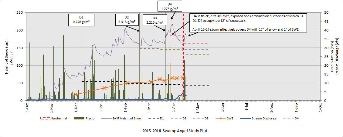
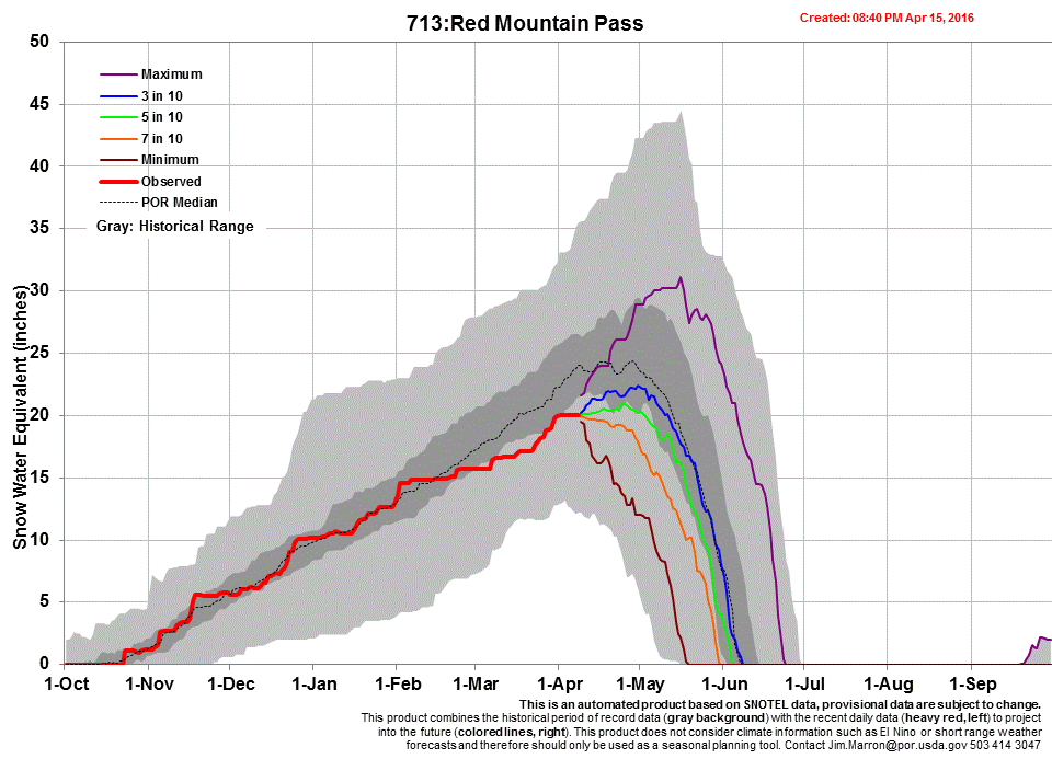
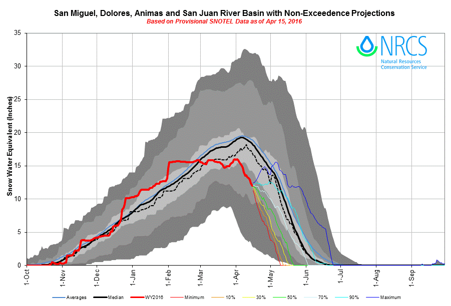
Senator Beck Basin – April 13
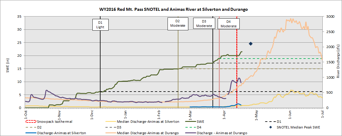
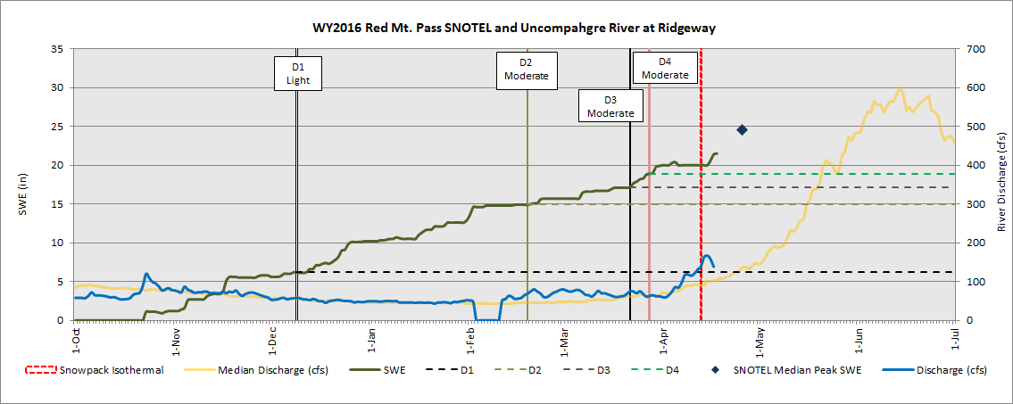
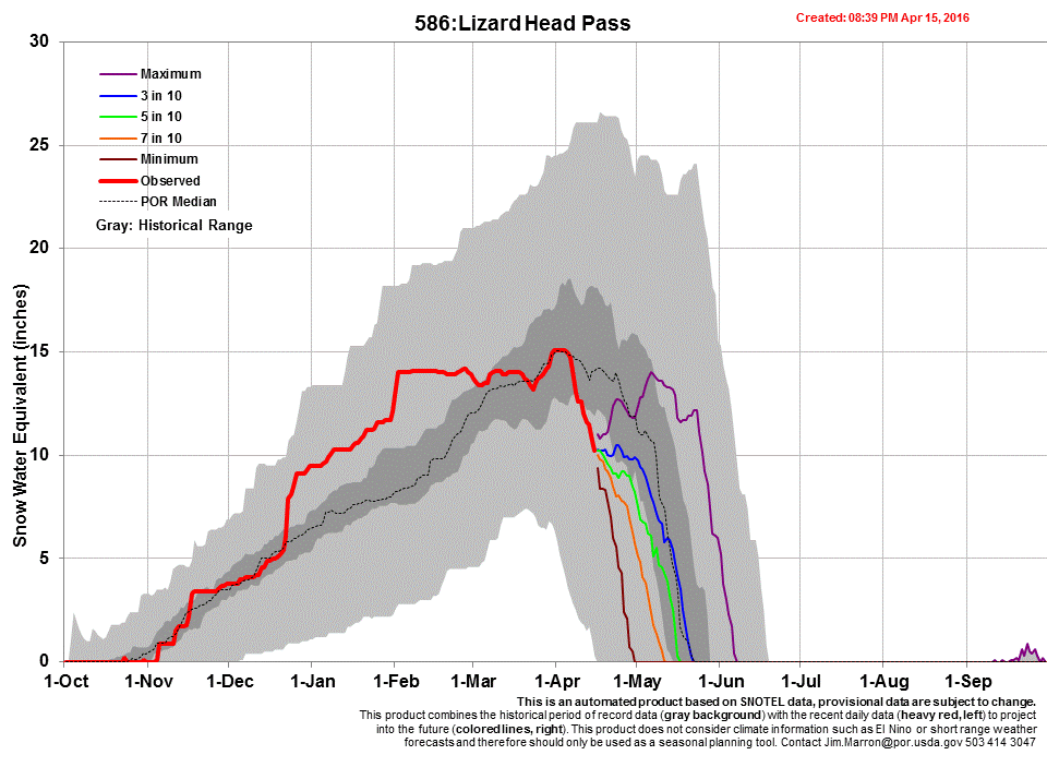
Between April 5 and April 13 the snowpack reached isothermal temperature at Swamp Angel Study Plot (SASP). As of April 13, D2, D3, and D4, at various intensities, occupied the top 1’ of the snowpack. Following the April 15-17 storm, 2.0” of precipitation, and 17” of new snow accumulation now cover the snow surface, effectively shielding the dust from direct solar radiation, on all aspects on Red Mountain Pass, as of this writing. Besides a 6” decline in SWE in March, SASP has been steadily increasing, and, currently, is 88% of average Peak SWE. Nearby Red Mountain Pass SNOTEL, as of April 18th, is 88% of median SWE. Lizard Head Pass SNOTEL to the southwest, in the Dolores River headwaters, experienced a very rapid loss of SWE in April (1/3 of total SWE since April 1st), and is currently 72% of median SWE, perhaps under heavier D2/D3/D4 snowmelt rate enhancement than observed in the other watersheds. Lizard Head Pass is arguably the closest headwater (Dolores River) to northeastern Arizona and southeastern Utah dust source areas. The April 15-17 storm brought 1.5” of precipitation to Red Mountain SNOTEL and 1” to Lizard Head Pass SNOTEL.
The April 13 snow profile at Swamp Angel Study Plot. Between April 5 and April 13 the snowpack reached isothermal temperature. D2, D3, and D4, at various intensities, occupied the top 1’ of the snowpack, but following the April 15-17 storm, 17” of fresh, clean snow has buried these dust bands, keeping these dust layers out of direct solar radiation in the short term.
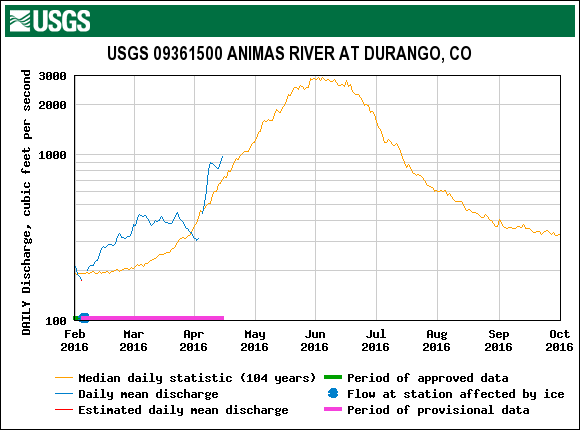
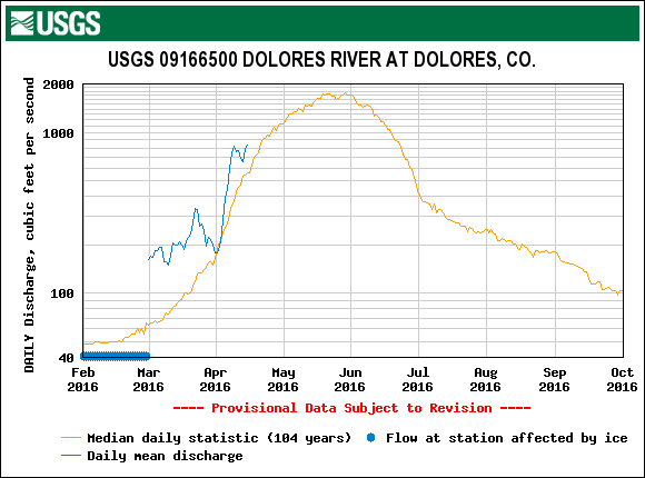
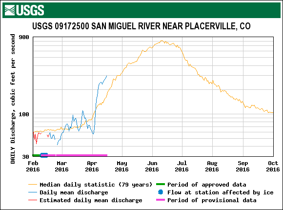
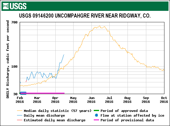
USGS gauge hydrographs from four watersheds, Animas River, Dolores River, San Miguel River, and Uncompahgre River for the CODOS WY2006-2015 period of record, are collated and presented in the DERC discussion on the SBB webpage. Snowmelt discharge rates have remained higher than each river’s median flow for early April in all of these watersheds. As of this writing, all of these rivers are seeing a reduction in discharge, for time being closer to their respective median, due to the recent storm and covering, to some degree, of D2/D3/D4. In our March 1st Update we posted the following analyses of WY2016 that narrowed the DERC domain based on prior Water Years. On March 1st, SNOTEL station data in the San Juan region varied greatly and ranged from LOW to HIGH, with LOW March 1st SWE attributed to Red Mt. Pass and HIGH March 1st SWE for Lizard Head Pass SNOTEL:
Uncompahgre near Ridgway (pdf)
San Miguel near Placerville (pdf)
Dolores River at Dolores (pdf)
Animas River at Durango (pdf)
In the San Juan area we still remain in the (comparatively) “AVG Dust” domain of the DERC rankings of dust intensity. For the Uncompahgre River near Ridgway, the prior Water Year that best resembles WY2016 so far is WY2012. This year was classified as LOW March 1st SWE, AVG Dust, and DRY Spring conditions. For the San Miguel near Placerville and Dolores River at Dolores, WY2008, HIGH March 1st SWE, AVG Dust, and DRY Spring, meet the criteria currently as classified by Lizard Head’s status. For the Animas River at Durango, WY2012 best resemble WY2016, to date.
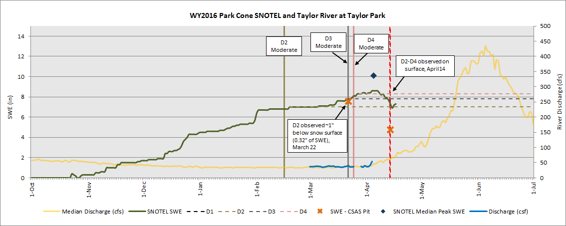
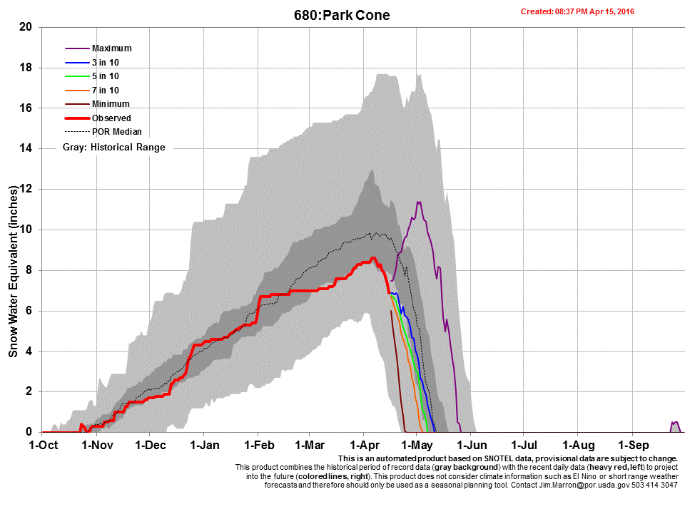
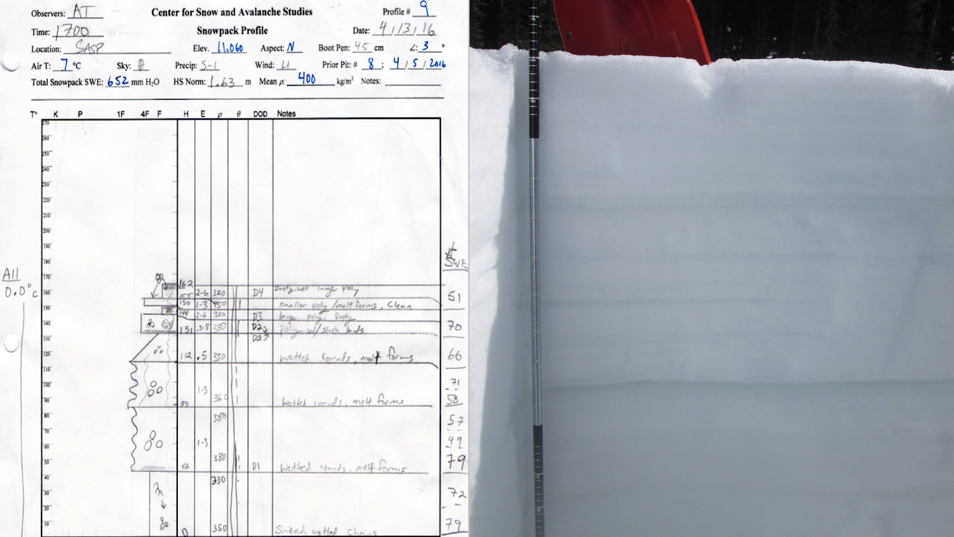
Park Cone – April 14
Our visit to Park Cone was the first time our field assistant, Andrew Temple with eight years of experience with CSAS, has been drenched with rain while digging a pit on a CODOS tour. The average temperature of the snowpack on March 22 was -1.8°C, and the temperature on April 14 was 0 °C. Judging by the warm weather conditions and depletion of SWE from 7.6” to 4.8” during this time frame, the snowpack has been melting for a couple weeks, likely since its typical date of Peak SWE of April 5. The Park Cone SNOTEL SWE plot do not show much of an upward bump following the April 15-17 storm, but much of the precipitation came as rain, close to 1” of precipitation altogether. On March 22, D2 was located just under a surface melt-freeze crust. Currently, all layers (D2/D3/D4) are merged at the surface. The recent passing storm and future storms this Spring will likely not cover (at least for very long given its elevation) the exposed dust, hence the remainder of the snowmelt season in this locale will be dust effected, accelerating snowmelt rates.
The Park Cone CODOS site is in an open, north-sloping meadow, uphill of the Park Cone snow course and adjacent to the Park Cone SNOTEL.
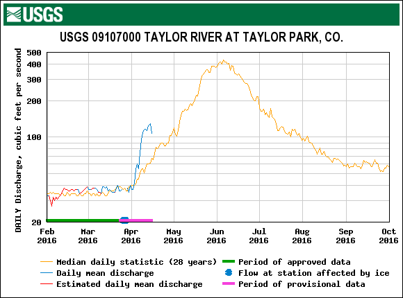
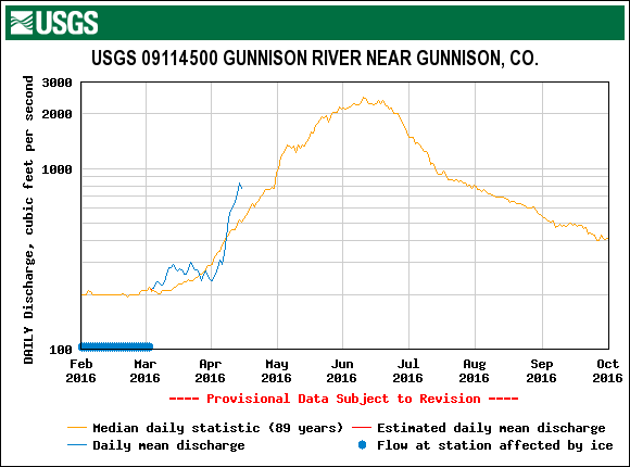
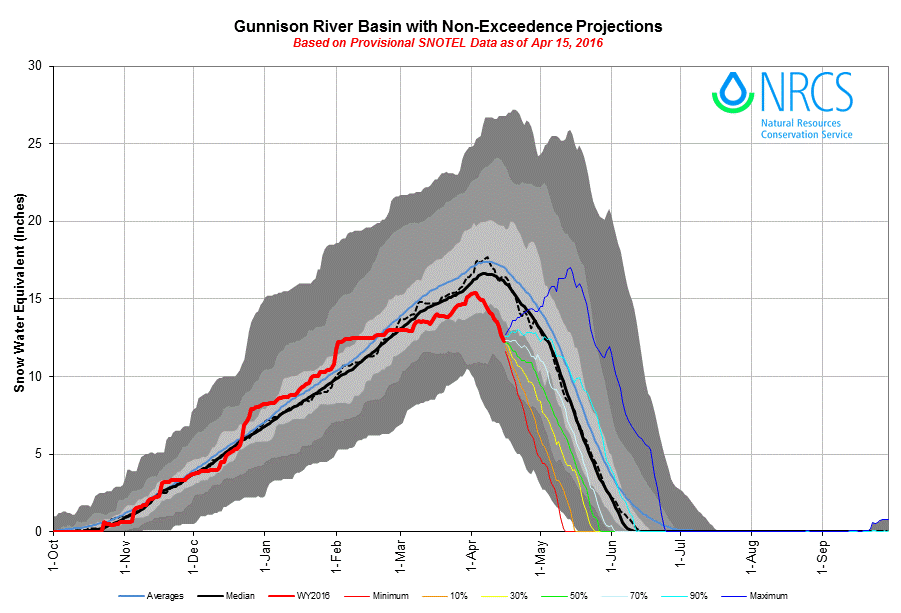
Early WY2016 snowpack formation at the Park Cone SNOTEL site was on track for an average to above average season until stalling in February and most of March. Recent storm events have helped, but Park Cone will fall short of its median Peak SWE by ~1.5”. Under the DERC approach, WY2016 at Park Cone has unfolded with LOW March 1st SWE, AVG dust intensity to-date, and overall DRY Spring weather so far. Previous years classified under the LOW March 1st SWE category are 2007 (DRY Spring and MIN Dust), WY2013 (AVG Spring and MAX Dust), and WY2015 (WET Spring and MIN Dust). The early onset and levels of WY2016 snowmelt at the USGS Taylor River at Taylor Park gauge mirror the WY 2007 and 2015 hydrograph, to-date, more so than the 2013 hydrograph.
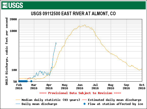
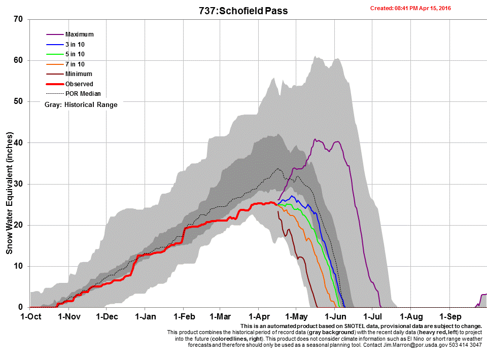
Nearby, the Schofield Pass SNOTEL has shown a similar pattern as Park Cone, with LOW March 1st SWE, AVG dust intensity (inferred from nearby CODOS sites) to-date, and DRY Spring precipitation, so far. Schofield is still hovering around its likely Peak SWE for the season of ~25.6” (median Peak SWE is 33.7”, on April 16). Within the CODOS DERC period of record at Schofield Pass, WY2012 is the only case of a prior Water Year with LOW March 1st SWE, AVG Dust intensity, and DRY Spring conditions. The early onset and levels of WY2016 snowmelt at the USGS East River at Almont gauge most closely mirror the WY2012 hydrograph, to-date. At present, in the absence of a major uptick in late April and May snowfalls, WY2012 is the closest analog in the DERC period of record to a likely pattern in WY2016 snowmelt runoff behavior in this East River tributary of the Gunnison River watershed. However, if a wet Spring ensues, like WY2015, we could see a strong climb of the ascending limb of the hydrograph well beyond the median peak lasting well into mid-June.
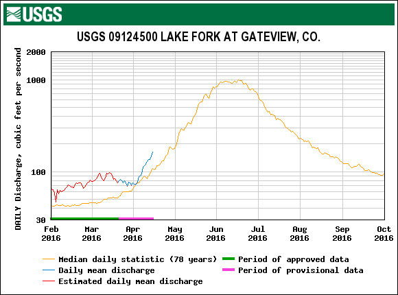
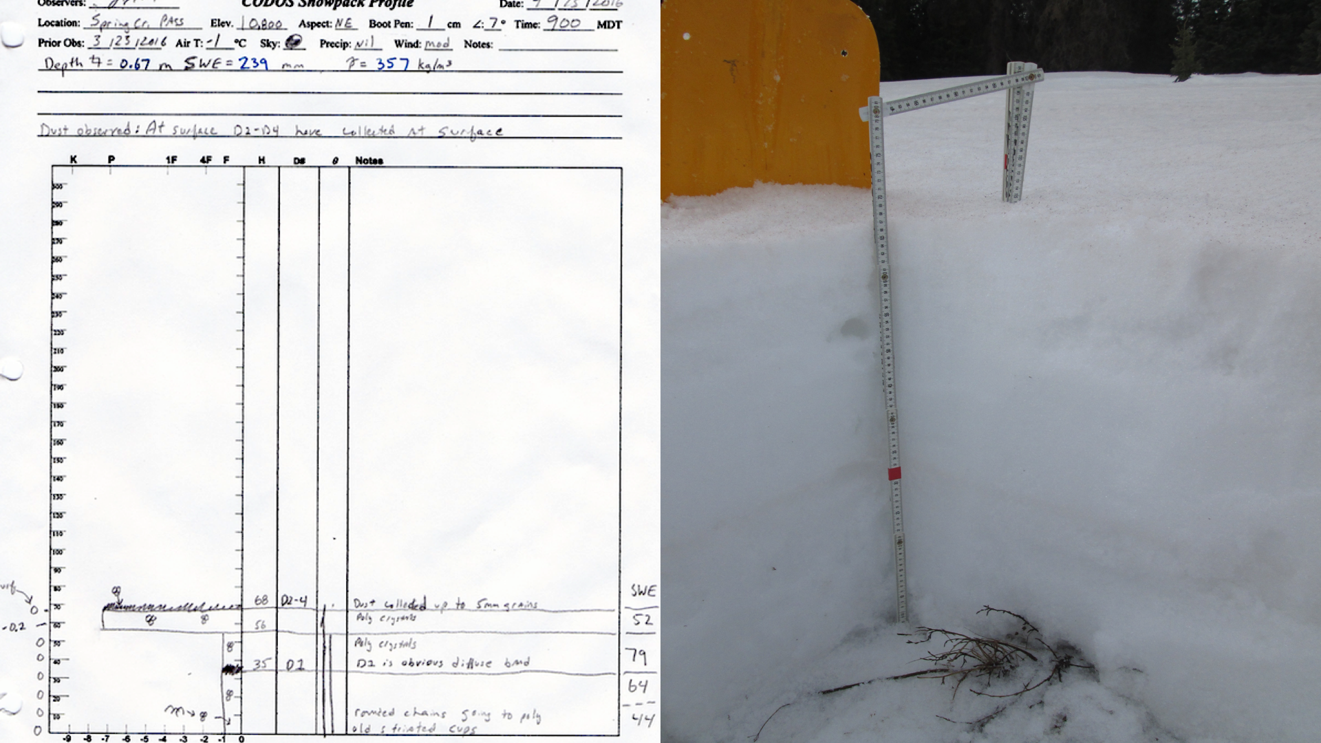
Spring Creek – April 15
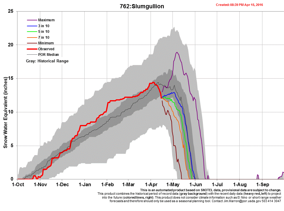
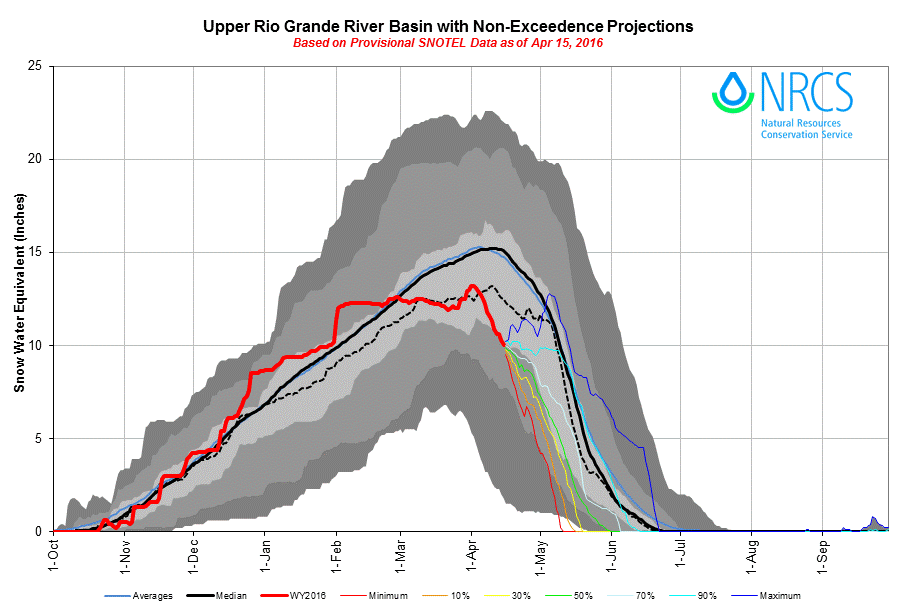
The snowpack at Spring Creek is isothermal with dust events D2/D3/D4 fully exposed over the entire landscape. Between our March 23 visit and April 15, SWE from the CODOS profiles went from 10” to 9.4”. Referencing the Slumgullion SNOTEL data (see plots), snowmelt has been ramping up since April 1st. From the April 15-17 storm, Slumgullion received 1” of SWE, 1.5” of precipitation and 13” of snow. SNOTEL data indicate Slumgullion likely reached its WY2016 Peak SWE of 14.8” on April 1st (median Peak SWE is 14.7” on April 17). The Lake Fork at Gateway stream gauge was measuring above median discharge beginning around April 1st, since April 15-17, the storm has temporarily inhibited snowmelt rates. Depending on future spring storms, this layer of clean snow overlying the D2/D3/D4 dust will be eventually be consumed by melt, exposing the dust to direct solar radiation. Snowpack albedo will be substantially reduced throughout the Rio Grande watershed, where snowpack remains in this area of the watershed, and dust-enhanced snowmelt rates will surge.
Spring Creek CODOS site on April 15. D2/D3/D4 are collected at surface of snowpack.
As it has unfolded, WY2016 exhibited “HIGH March 1st SWE” at the Slumgullion SNOTEL and has produced an AVG Dust intensity and AVG Spring since then. WY2008/WY2011/WY2014 hydrographs for the Lake Fork at Gateview may be the best analogs to WY2016 behavior within our CODOS period of record.
Colorado Division of Water Resources hydrographs for the CODOS WY2006-2015 period of record are collated and presented in the DERC discussion on the Spring Creek and Wolf Creek webpage, the Spring Creek pdf is located at this link:
Lake Fork at Gateview (pdf)
Surrounding landscape at Spring Creek CODOS site on April 15. Dust was observed on surface on March 23 over majority of landscape, on April 15 dust was exposed entirely on snow and bare ground exists in many places.
A few miles down the road from the Spring Creek site on April 15. Snow cover depletes quickly with elevation.
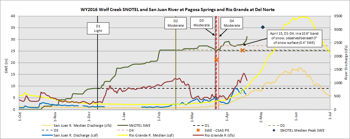
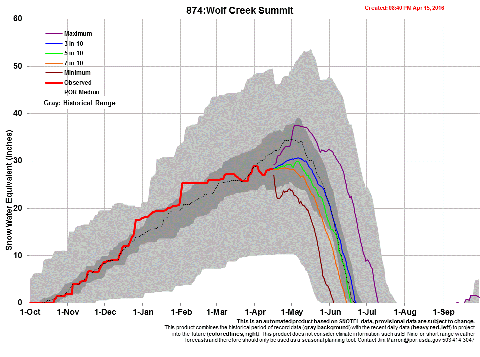
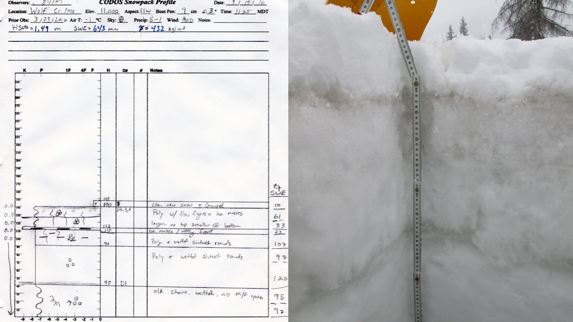
Wolf Creek Summit – April 15
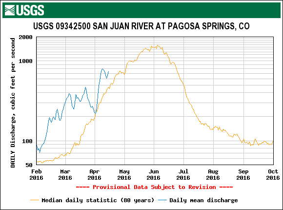
The Wolfe Creek Summit snowpack was very near isothermal conditions (-0.5°C) on March 23, and as might be expected it was completely isothermal on April 15. As of April 15, D2/D3/D4 was below 0.39” of SWE and 3” of snow. The new snow accumulation that ensued after our departure resulted in an additional 3.4” of SWE, 16” of snow depth, and 2” of precipitation, according to Wolf Creek Summit SNOTEL. Hence, the dust is now isolated from the surface by this new accumulation. The CODOS snow profile show SWE increased from 21.4” to 25.3” between the two visits. As seen at other locations around the state, streamflow which was showing a surge the first two weeks of April well above median flows, has, for the last few days, decreased (due to the storm and reduced albedo of the snow surface) to near median as of this writing.
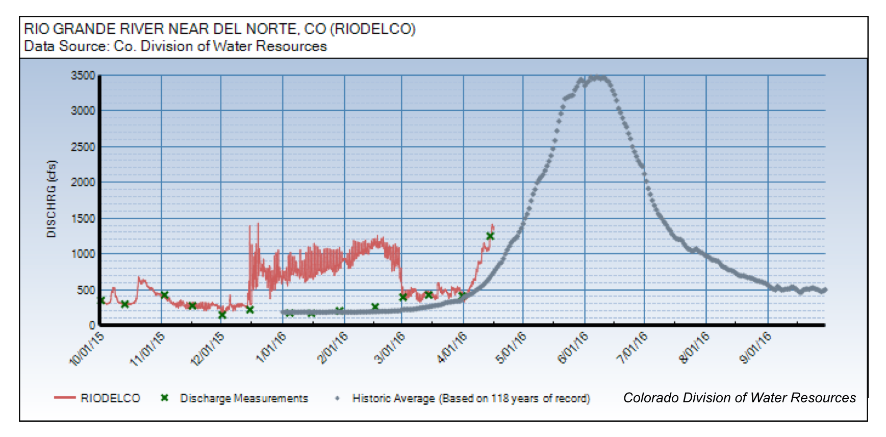
Wolf Creek so far this season is best categorized as AVG March 1st SWE, AVG Dust, and AVG/DRY Spring. As was the case in WY2015, this year’s discharge, to-date, on the San Juan River resembled WY2012 flows (and WY2007 to some degree) with early onset of snowmelt to above median levels for early April (see the Hydrographs at the Wolf Creek Pass CODOS webpage). A similar pattern, albeit with lower amplitude so far this year, is seen on the Rio Grande hydrographs for this year, to-date, and during early runoff in WY2012. USGS gauge hydrographs from those two watersheds for the CODOS WY2006-2015 period of record, including WY2012, are collated and presented in the DERC discussion on the Wolf Creek Pass webpage, at these links:
Wolf Creek Summit CODOS snow profile on April 15.
Bird’s eye view of the CODOS snow profile at Wolf Creek Summit on April 15. This location received another ~16” of snow accumulation, April 15-17) after this picture was taken.
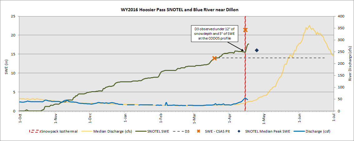
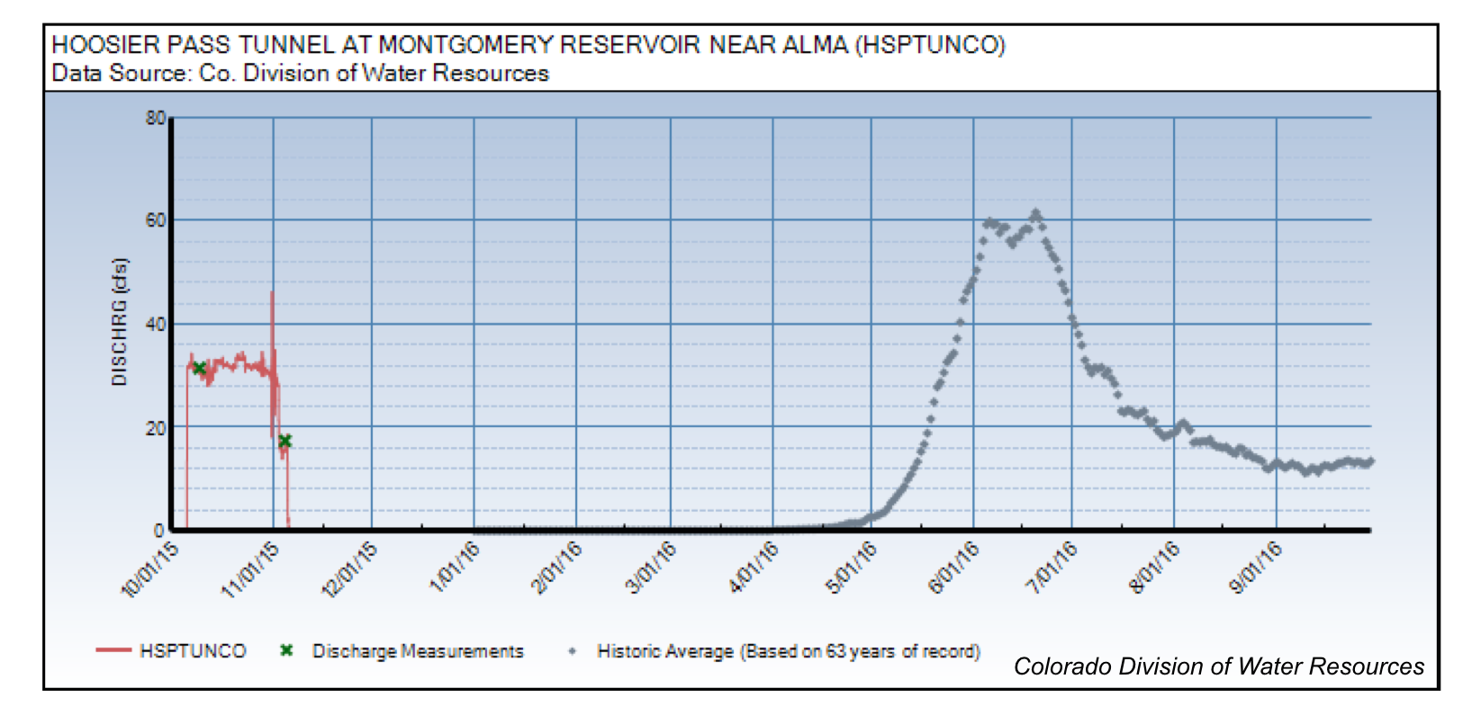
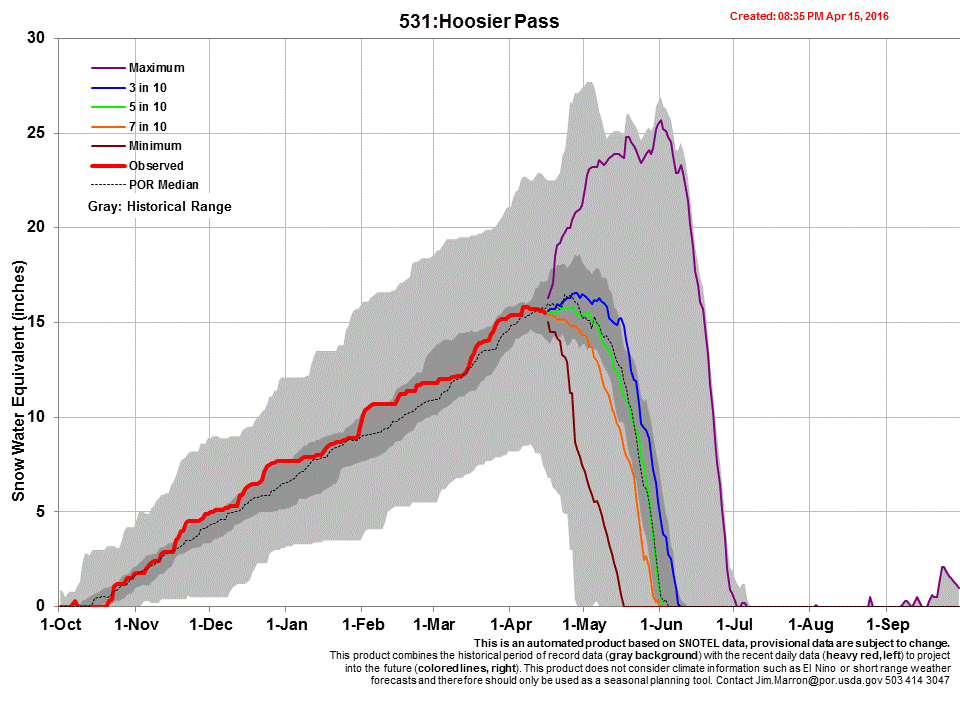
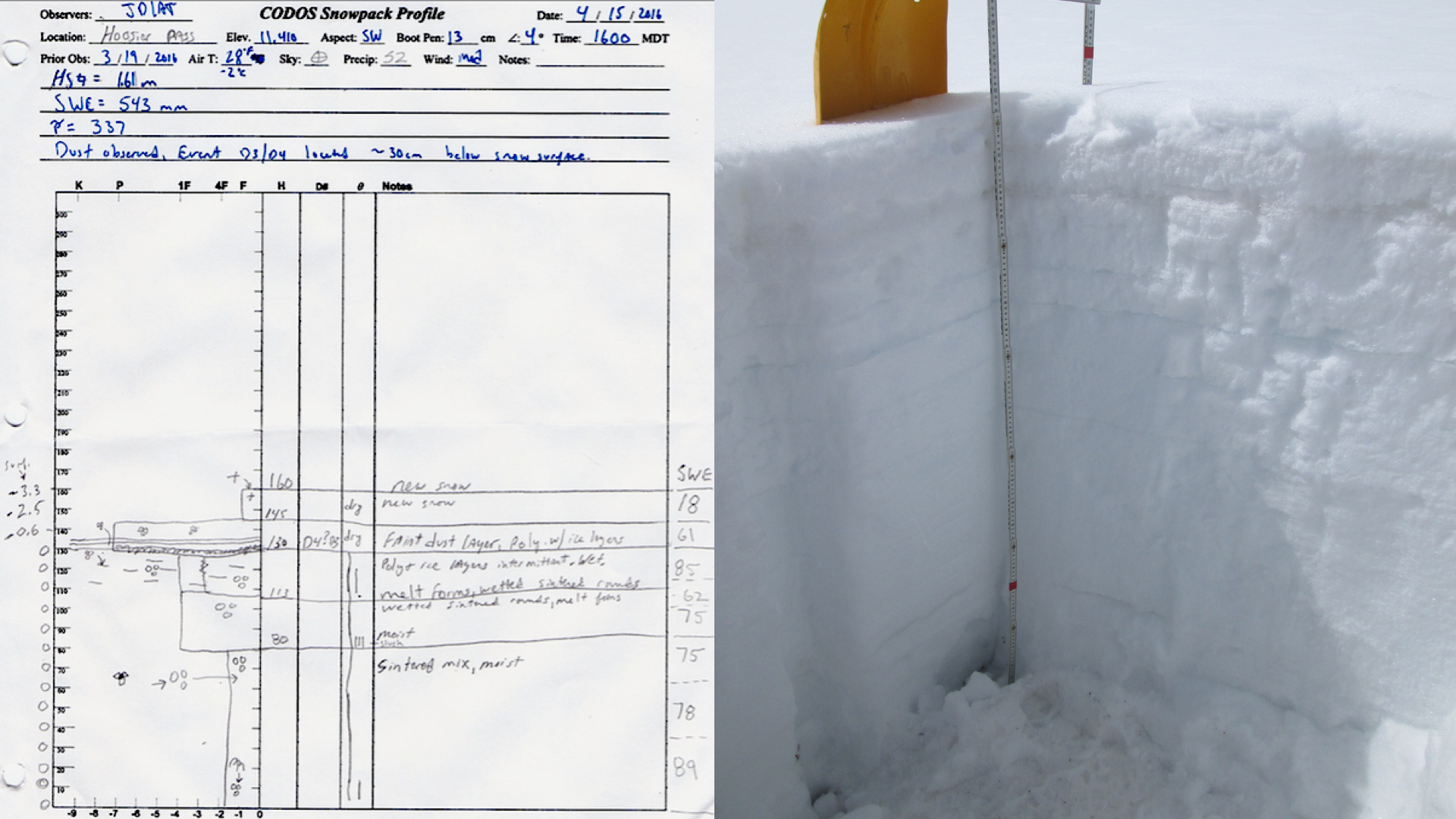
Hoosier Pass – April 15
Snow cover in the Hoosier Pass vicinity has sustained its above median SWE status. Hoosier Pass SNOTEL was 108% of median SWE on March 1st and currently is 111%. CODOS SWE measurements increased from 14” on March 19th to 21” on April 15th. The snow profile was performed late in the day on April 15, just as the April 15-17 storm was ramping up. At that time, there was already 6” of observed new snow accumulation. SNOTEL data show a total 20” gain in snow depth, 2” of SWE, and 2.5” in precipitation.
On April 15, the CODOS team observed D3 dust layer 12” below the snow surface, with the new snow accumulation on April 15-17, it is now likely ~32” below the snow surface (see multivariable plot). This new layer since our March 19 visit is faint and will likely not play a role in snowmelt rates in the near future (~2 weeks).
Using the DERC approach WY2016 at Hoosier Pass has unfolded with AVG March 1st SWE, MIN Dust intensity, to date, and overall near AVG Spring precipitation, so far. In our March 1st Update we posted the following analysis of WY2016 that narrowed the DERC possibilities for Hoosier Pass to prior Water Years with AVG March 1st SWE.
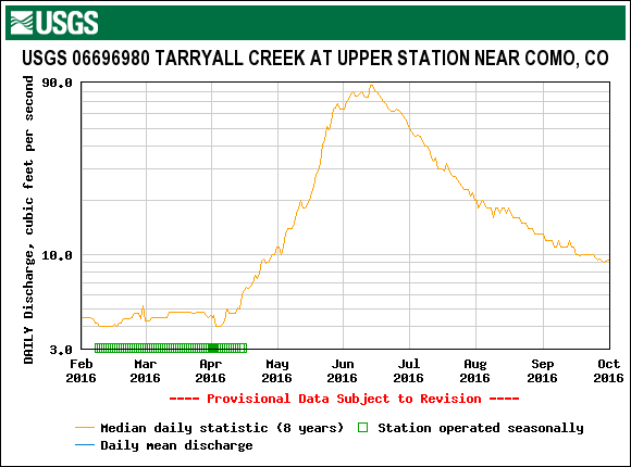
Within the DERC period of record at Hoosier Pass there are many previous Water Years that could be plausible indications of the runoff scenario this Spring. There are no years meeting the current criteria, but since the median snowpack started above average (108%) and has increased slightly to 111%, Water Years in the High March 1st SWE category (particularly 2007 and 2015) could apply. If we receive heavy dust events going forth, there is one AVG March 1st SWE year, WY2010, with AVG March 1st SWE, MAX Dust intensity, and AVG Spring conditions that appears it could only somewhat resemble WY2016 runoff – if that were the case. Currently, D3 will accelerate snowmelt rates somewhat, once it becomes more widely exposed. So it is likely at present, in the absence additional significant dust depositions, WY2007 represents the closest analog in the DERC period of record to likely patterns in WY2016 snowmelt runoff behavior in the Blue River and Tarryall Creek watersheds.
The Hoosier Pass snow profile on April 15, 2016. In this photo, a light dust event (D3) is located 1’ below surface, this was covered another 20” during the April 15-17 storm event.
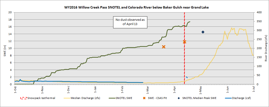
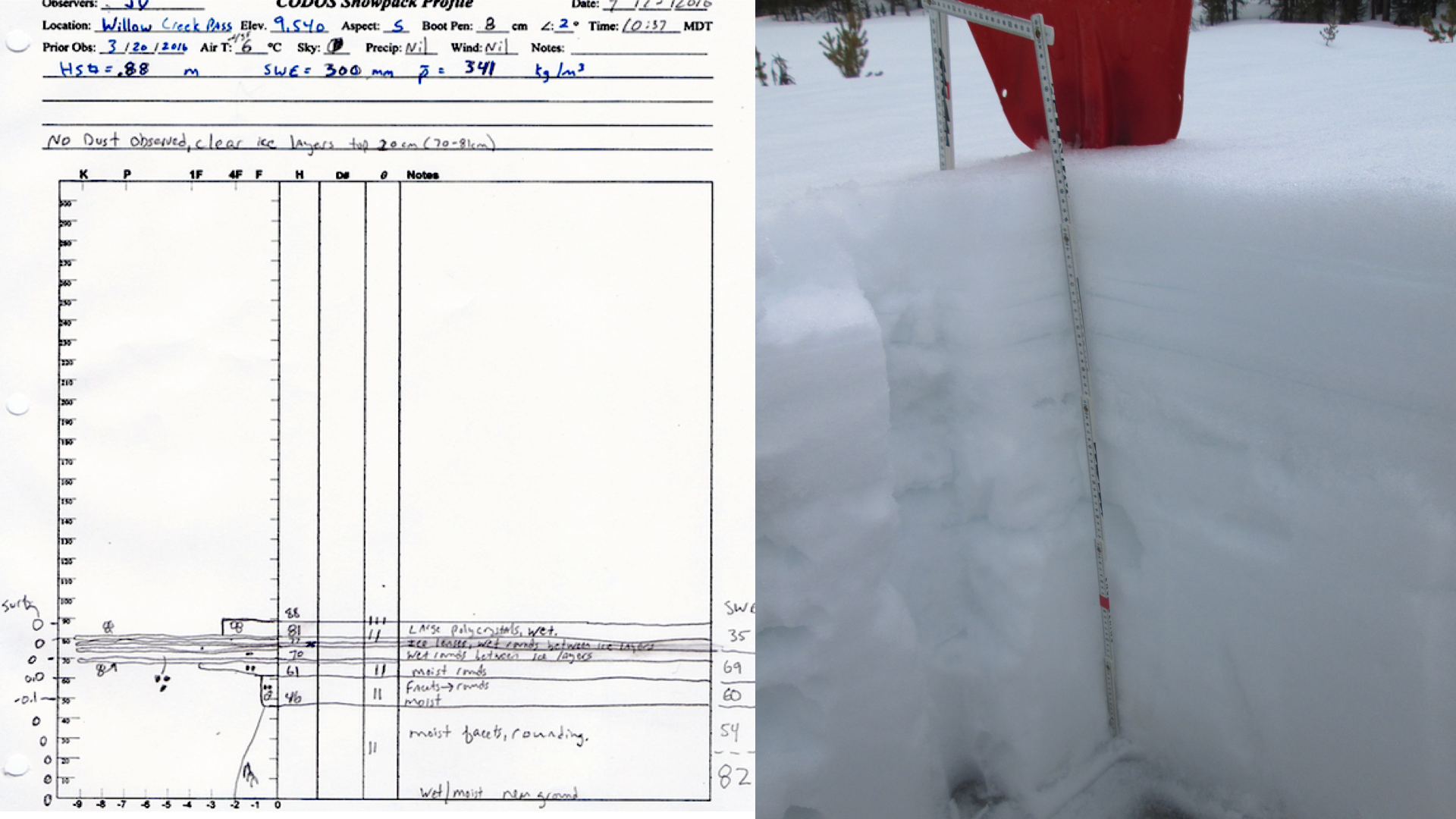
Willow Creek – April 14
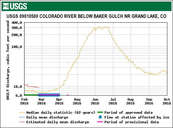
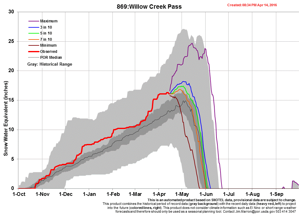
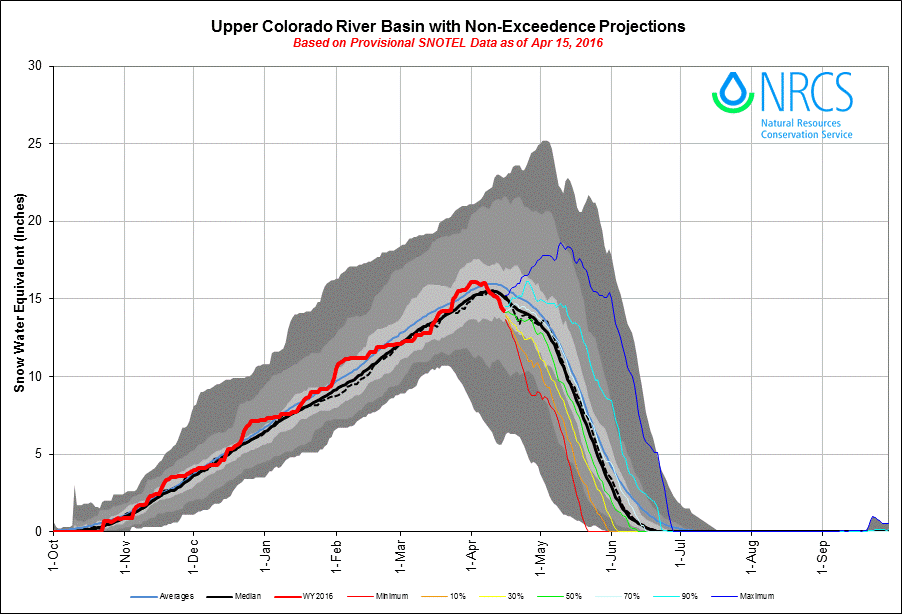
Willow Creek, together with Rabbit Ears Pass (and possibly Grizzly and Berthoud CODOS sites), has remained dust free so far the WY2016 winter season. The snowpack is now isothermal. The CODOS profile SWE increased from on 10.4” on March 20 to 11.8” on April 13. After the April 15-17 event Willow Creek Pass SNOTEL received an additional 1.3” of SWE, 8” of snow depth, and 1.1” of precipitation and is currently at 120% of median peak. The Upper Colorado River Basin is at 98%.
Under the DERC approach, WY2016 at Willow Creek Pass has unfolded with HIGH March 1st SWE, MIN Dust intensity, to-date, and perhaps almost WET Spring precipitation that has sustained an above-normal rate of snowpack accumulation since March 1st. In our March 1st Update we posted the following analysis of WY2016 that narrowed the DERC domain for Willow Creek Pass to prior Water Years with High March 1st SWE:
Although the USGS Colorado River below Baker Gulch stream gauge has only begun to record data, within the CODOS DERC period of record at Willow Creek Pass, there is no comparable year characterized as HIGH March 1st SWE, MIN Dust, and AVG Spring. The closest within the DERC model is WY2007 (HIGH March 1st SWE, MIN Dust intensity, and DRY Spring), WY2008 (HIGH March 1st SWE, AVG Dust intensity, and AVG Spring), and WY2011/2014 (HIGH March 1st SWE, AVG Dust, WET Spring). The stream gauge is not operational as of this writing so dialing in comparisons will be delayed until data is available.
The Willow Creek snow profile on April 14.
At Willow Creek sample site, looking across clearing towards direction of Willow Creek Pass SNOTEL.
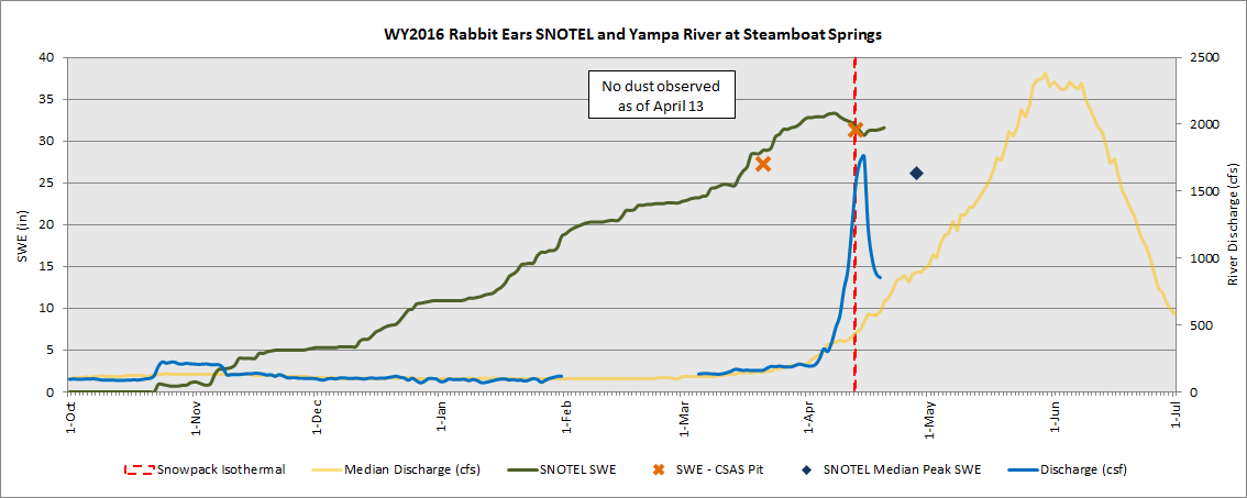
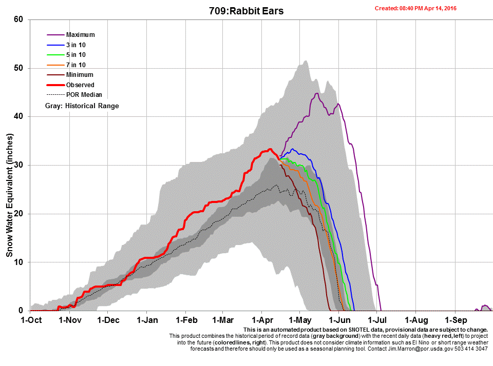
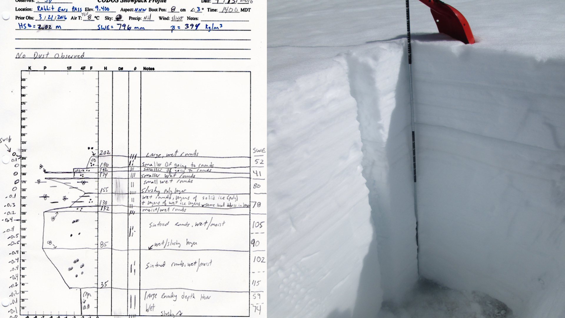
Rabbit Ears Pass – April 13
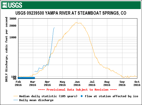
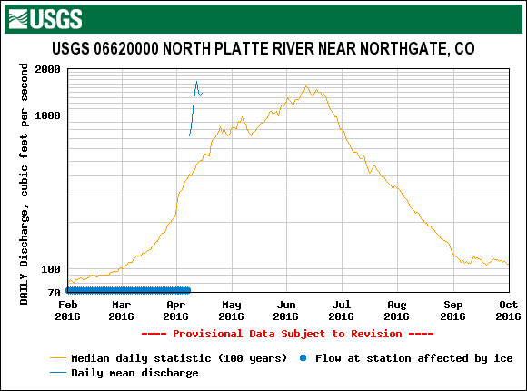
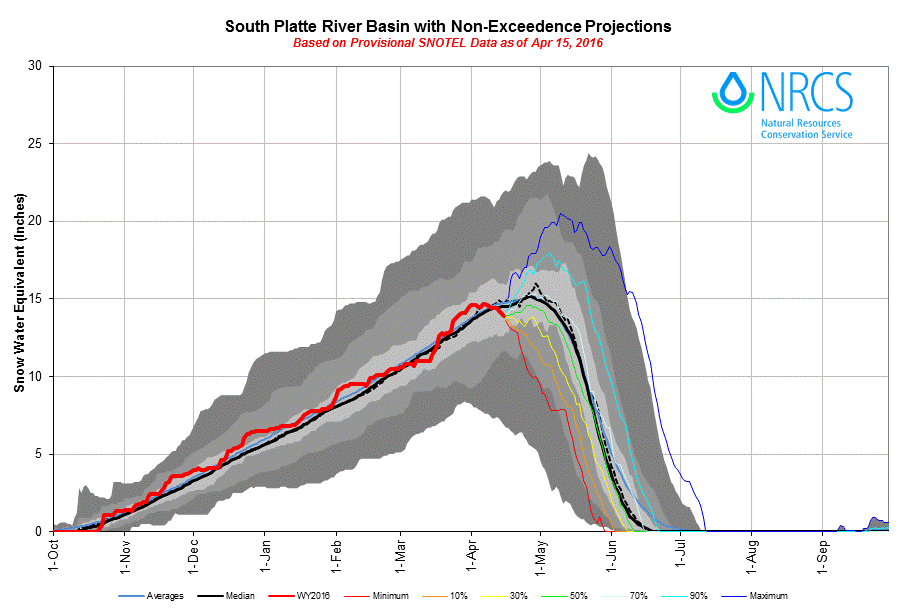
The second snow profile at Rabbit Ears Pass of the season was performed on April 13, located in an open wetland near the Rabbit Ears Pass SNOTEL. This site in northern Colorado has remained dust free so far this season. The snowpack has just recently reached isothermal conditions (average profile temperature of -0.4° C). Rabbit Ears is also doing very well in terms of SWE, currently 121% of median peak. Between March 21 and April 13 our CODOS site went from 27.3” to 31.3” of SWE. The Yampa and North Platte Basin is currently at 96% of average. Presently, the DERC status of this site is HIGH March 1st SWE, MIN Dust, and AVG/WET Spring. If the Spring classification continues to lean toward WET, it would be a first for this location. There have been other HIGH March 1st SWE years (2006, 2008, 2009, 2011, and 2014) and they have all resulted in above median discharge on the Yampa River at Steamboat Springs. This is currently the case seeing the sharp surge in the hydrograph (Yampa River at Steamboat Springs) so far this Spring. As of now, the hydrograph most closely resembles WY2006 and WY2014.
The Rabbit Ears snow profile April 13, 2016. Snowpack just now achieving isothermal conditions. Notice slush at bottom.
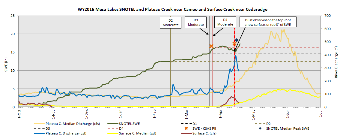
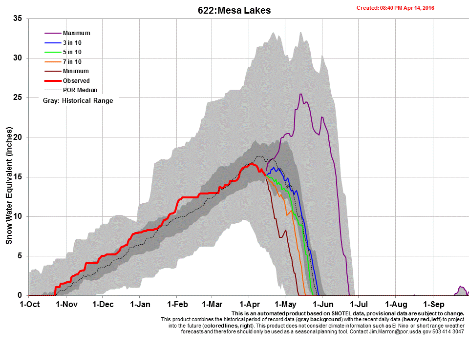
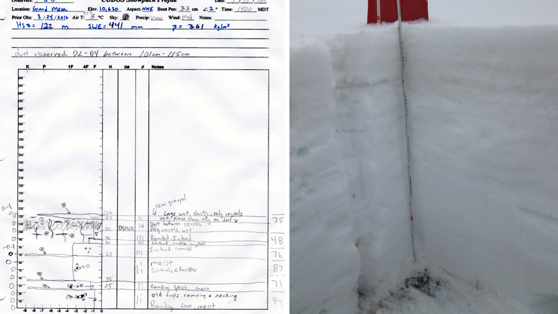
Grand Mesa – April 14
Grand Mesa was visited April 14 just prior to the April 15-17 storm. At that time, D2/D3/D4 occupied the top 8” of the snowpack, including the snow surface. Following our April visit, according to Mesa Lakes SNOTEL, the area received 2” SWE, 12” snow depth, and 1.7” of precipitation. Over the three weeks since the previous CODOS trip, SWE increased from 16.6” to 17.3” and the snowpack is now isothermal. Mesa Lakes SNOTEL is now 1” short from reaching median Peak SWE.
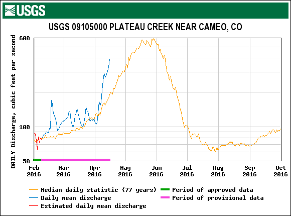
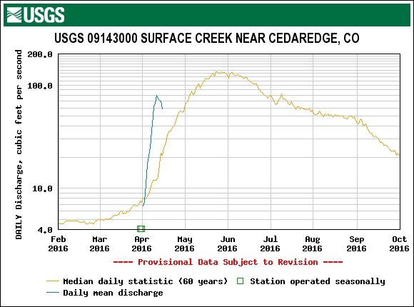
WY2016 unfolded to exhibit AVG March 1st SWE at the Mesa Lakes SNOTEL and has produced an AVG spring since then with AVG dust conditions to date, this year’s discharge on Plateau Creek resembles early WY2014 runoff. Surface Creek discharge data began at an unusually high level in early April 2016 but have declined since. USGS gauge hydrographs from those two watersheds for the CODOS WY2006-2015 period of record, including WY2014, are collated and presented in the DERC discussion on the Grand Mesa webpage, at these links:
Plateau Creek near Cameo (pdf)
Grand Mesa snow profile on April 14 with Grand Mesa Study Plot in the background.
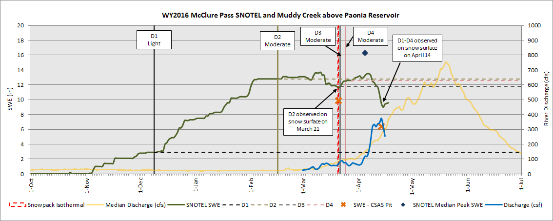
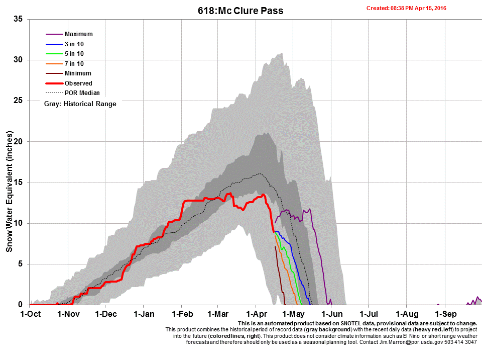
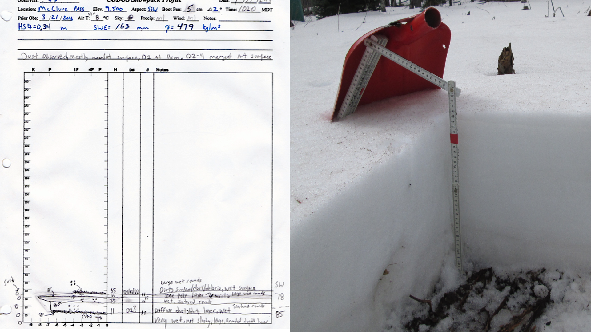
McClure Pass – April 14
Spring has been well underway at McClure Pass for some time. Isothermal conditions were observed on March 21 and since then snowpack has lost 35% of SWE at the CODOS sample location. At McClure Pass SNOTEL SWE depletion leveled off, and even slightly increased in latter March, but now melt is firmly underway. CODOS measured SWE is well below that reported by McClure SNOTEL with just a few hundred feet distance between the two sites (see multivariable plots). On April 14th measured CODOS SWE was 6.4” vs SNOTEL value of 9.5”. The 2 days prior to our visit melt rates reached 1” of SWE loss per day according to SNOTEL data, and the recent storm appears to have arrested the melt over the last few days. WY2016 snowpack formation stalled at McClure Pass since the first of February, and no significant storms occurred since. This site is well past its date of median Peak SWE date of April 5 and is currently 61% of its seasonal median peak value.
The McClure Pass CODOS site with the McClure Pass SNOTEL in the background.
Under the DERC approach, WY2016 at McClure Pass was defined as having AVG March 1st SWE conditions at 101% of median Peak SWE, but by the March 27 CODOS Update it had already fallen to 77% of its median. Thus, the CODOS classification has unfolded with AVG March 1 SWE, AVG Dust intensity, to date, and overall DRY Spring weather. In our March 1st Update we posted the following analyses of WY2016 that narrowed the DERC domain for McClure Pass to prior Water Years with AVG March 1 SWE:
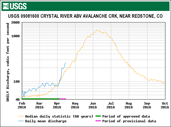
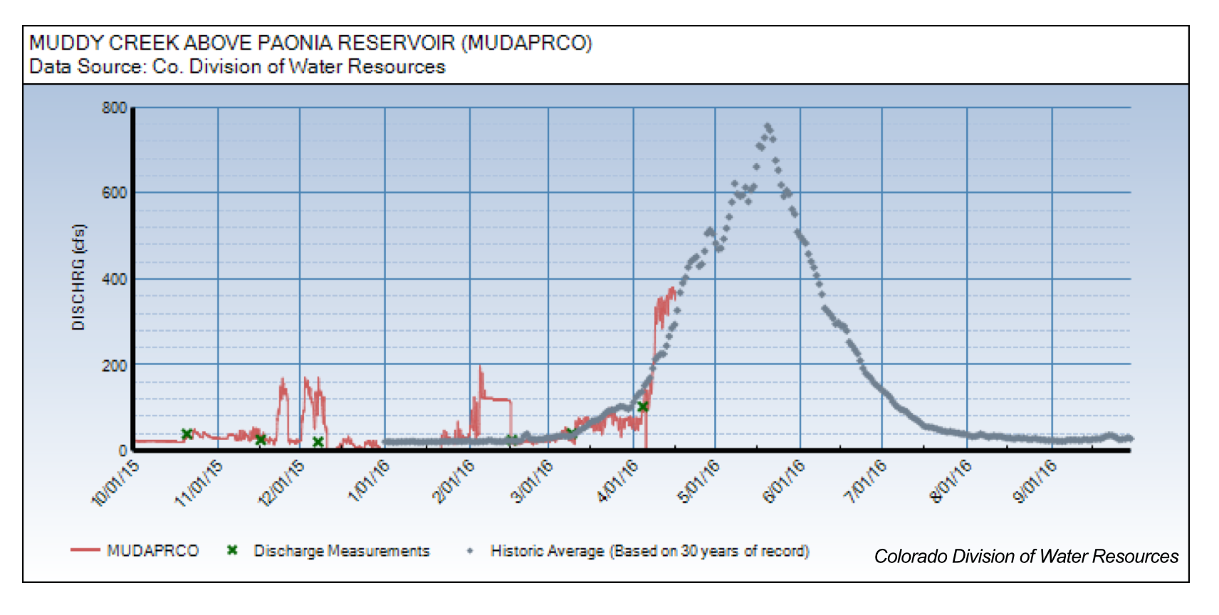
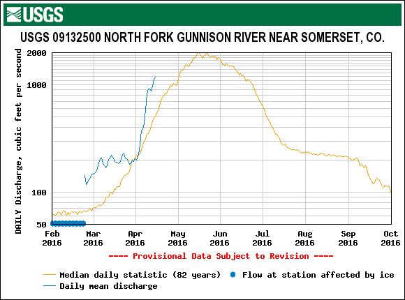
Even though there is no direct analog in the DERC model for McClure Pass, WY2006, WY2007, and WY2010 remains the closest analog in the DERC records to a likely pattern in WY2016 snowmelt runoff behavior in the Muddy Creek, North Fork of the Gunnison watersheds. For Crystal River, being based off the Schofield WY2012/2013/2015 appear to be a better analog. Current hydrographs for Muddy Creek and the North Fork of the Gunnison, on the west side of McClure Pass, and for the Crystal River to the east, all reflect the early surge of snowmelt.
Dust-on-snow has been an active variable in snow ablation since January 16 when D2 occurred, since that time D2 has been at or very near the surface (see multivariable plot). It was verified D2 was located at the snow surface on March 21, and on April 14, D2 and likely D3 and D4 are also located at the surface, intensifying melt rates. The April 15-17 storm bought 0.6” of precipitation but no significant snow accumulation, so the dust will remain on the surface, exposed to solar radiation and accelerating snow ablated.
The McClure Pass CODOS site with intermittent snow cover. Snow cover rapidly decreases with elevation going towards Marble as well as Paonia.
Weather & Climatology
As of this writing, Wednesday night, April 20, 2016, the National Weather Service Grand Junction office expects the long-lasting low pressure system to dissipate the evening of April 20 followed by much drier and warmer period for the rest of the week. On Saturday another low pressure system will arrive with forecast for rain and snow to northern Rockies and higher winds in southern Colorado. Beyond that, the next system to move in early next week is still to be ascertained. There is another system after that late next week, so we are still maintaining our chances to see wet weather.
The Climate Prediction Center April through June outlook shows increased chances of above average precipitation for Colorado with enhanced opportunities for precipitation in southeast and central Colorado. Temperature probability map indicates increased chances of above average temperature in western and northern Colorado.
