CODOS UPDATE APRIL 25, 2025: Looking Towards Peak Flow
Greetings from Silverton,
With the southern Colorado’s struggling snowpack, warm weather, surface dust, and weather forecast, it is looking like streams and rivers will peak early this runoff season. Peak flow is a topic we usually hit on in spring and in past updates have discussed in detail.
Here in our Senator Beck Basin, we have discussed previously the relationship of snow-all-gone dates and peak flow in our stream gauge and downstream in the Uncompahgre and Animas gauges, which mirror each other pretty well. We have been investigating this in detail through a close collaboration with Colorado State University and finally the work has been published in the research publication Water. This will be published very soon and we will post to our website when available. For now see a short piece about the study here.
Dust severity is not as bad as in recent years, but the persistent current surface dust combined with the sunny/warm weather is chipping away at the snowpack. And the light buried dust layers will be merging at the surface as well as spring progresses, further darkening the surface. It is also worth the reminder that new dust events can happen anytime, which would be deposited on the surface and having an immediate effect. As of this writing high winds and dust warnings are in effect in the Four Corners region.
This year, with very little snow at lower and mid elevations, we are guessing that snowmelt contributions from the ~11,000’ level as well as elevations above tree line will constitute peak flow, which would mean the second peak will be the actual peak. For the Animas at Durango, we are guessing a peak date of May 16-18 with a discharge of ~2,300 cfs. On the Uncompahgre side, the timing will be closer to latter May as that watershed comprises of more higher elevations, and a discharge of around 600 cfs?
Take Care
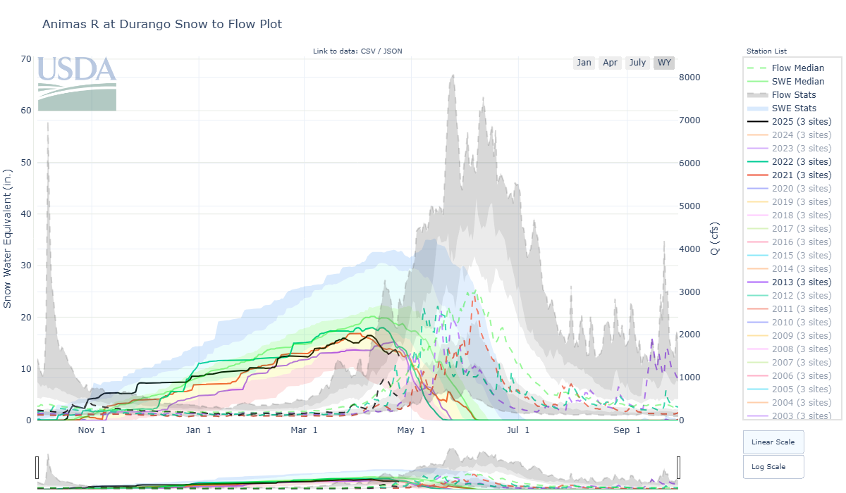
Below: Snow to Flow plots for select watersheds.


Below: Correlation of snow disappearance date at Swamp Angel Study Plot and Senator Beck Study Plot and the first streamflow peak and second peak. When snow is gone at Swamp Angel we can expect the first peak of the snowmelt hydrograph, and when snow is gone at Senator Beck we can expect the second peak. Which peak is the largest varies, but often depends on factors like snow amounts at all elevations bands, spring weather, and dust severity. In the below plots, the red dot is a water year with high dust severity, the green is average severity, and the blue dot was low dust water year. So by estimating snowmelt rates based on dust, spring weather, and how big the snowpack currently is, you can get pretty close to a peak flow date.
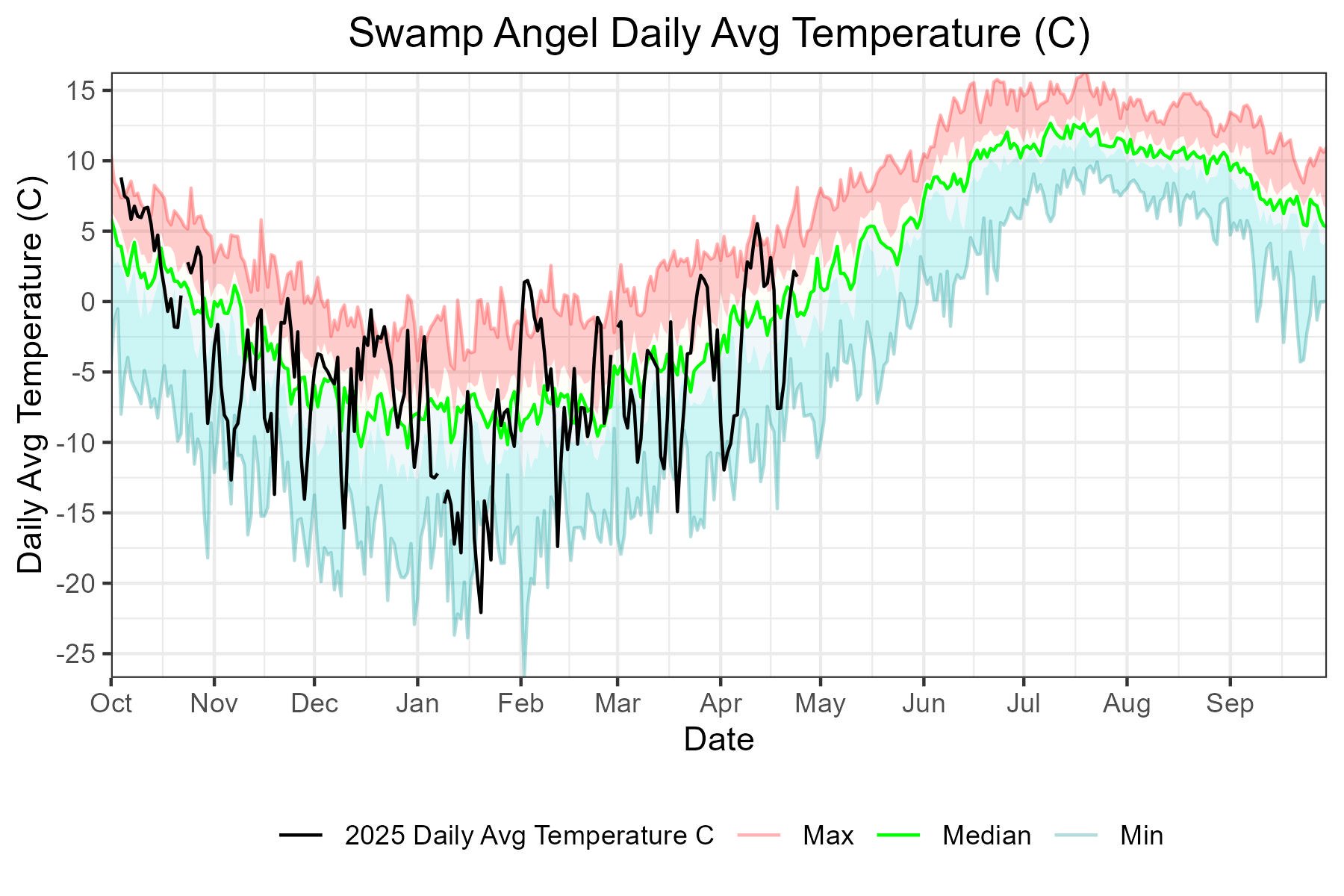
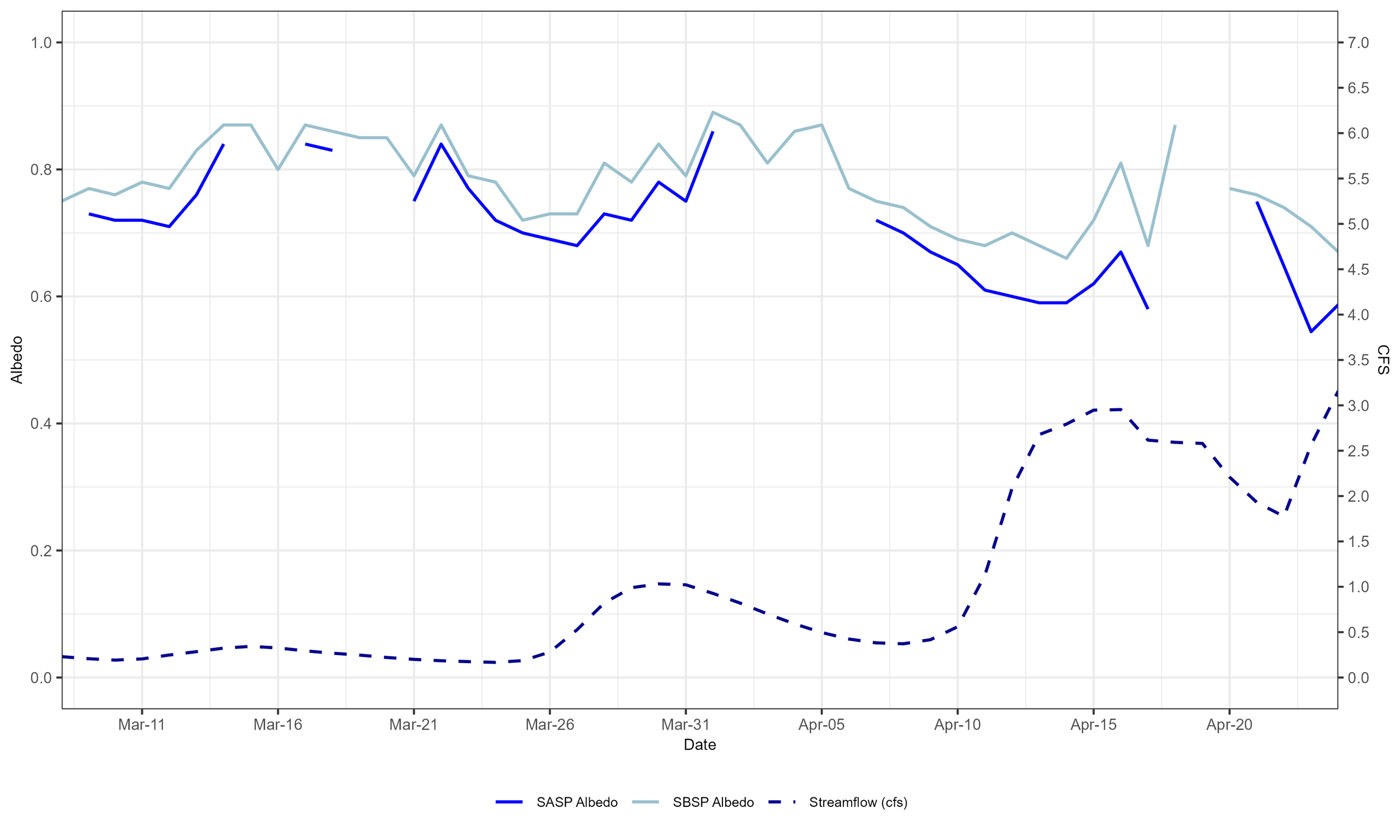
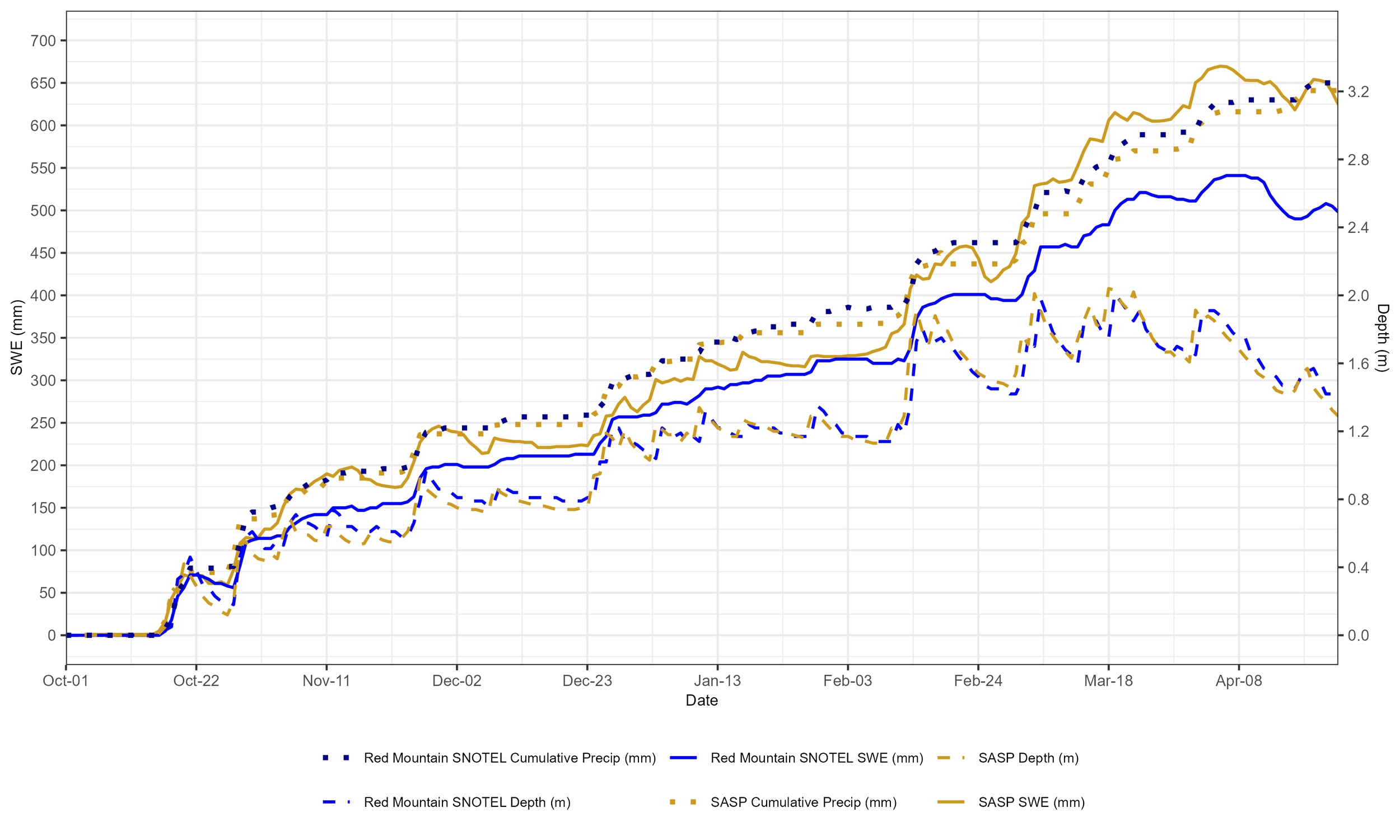
Snow depth at Swamp Angel is about 50”, and SWE is 23.8”. Up at Senator Beck, snowpack depth is 49”. Below we have plots for snow depth, SWE, and cumulative precipitation for Swamp Angel, Senator Beck, and Red Mountain Pass SNOTEL. We also have daily average temperature and cumulative precip for Swamp Angel with min, median, and max shading. Our stream gage is picking up in volume - we like to plot that with albedo since we see such good correlations between the two. Swamp Angel cumulative precipitation is 86 % of the median (POR 2002-2023) for this season.


Last summer, along with lots of other cool station instrumentation upgrades, we installed some vertical snow temperature sensors. We are working on some visualizations with those, and here are a couple animations of what the daily average temperature in the snowpack at Swamp Angel Study Plot (11,186’) looked like for a week at the beginning of March vs the beginning of April. You can see that in March, we had much more dynamic temperature gradients throughout the snowpack, whereas now the snowpack is isothermal and ripe to melt.
And, unfortunately, we already have our thoughts on this year’s fire season. It never hurts to be thinking ahead and preparing. We had a low snowpack, and so far, a pretty dry spring, which is forecasted to continue. Check out the map below interactively at this link: https://co-pub.coloradoforestatlas.org/#/. As of this month, La Nina has ended, and we are likely to stay in neutral conditions. One bit of hope for precipitation is jumping ahead into the time of the monsoons. Below the Burn Probability Map, you’ll see the Climate Prediction Center’s forecast for July, August, September. We would love to see some above average, mid-late-summer precipitation!

