

Summary
Merged dust layers D4 and D3 were extensively exposed at the snowcover surface near Taylor Reservoir on April 23, 2014 and snowcover was considerably reduced since our prior March 28 site visit.
Evidence of dust layers D4/D3 was even more dramatic around Crested Butte, as seen in this photo of the ski area taken later in the afternoon of April 23.
Widespread emergence of dust-on-snow event D4-WY2014 (March 30, 2014), now merged with layer D3 (March 26), resulted in rapid warming of the Upper Gunnison basin snowpack toward or to isothermal. Two significant snowmelt runoff surging episodes ensued in April, reaching near-median peak flow levels several weeks earlier than normal on the East River and Gunnison main stem. Since our site visit, the winter storm of April 26/27 and subsequent precipitation has buried the merged D4/D3 dust layer underneath a layer of new snow, restoring high albedo to the watershed. Snow temperatures in the April 23 CODOS snow profile were isothermal at 0.0° C and the overlying new snow will quickly become isothermal as well.
Snow Profile
At 62 cm (24.4”), this snow profile was one-half as deep as the March 28 profile at Park Cone. Merged dust layers D4 and D3 are seen in the snow surface. Snow temperatures in this profile were isothermal, at 0.0° C throughout, and the snow was very wet or slushy, with almost no structural strength, collapsing to the ground as we approached the site on skis.
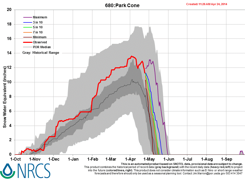
The March 28 snow profile at the Park Cone CODOS site. At 126 cm (49.6”), this was the deepest snow profile that the CODOS program has ever performed at Park Cone. Although the snowpack presented clear evidence of recent surface melting episodes, snowpack temperatures had cooled and the mean snow temperature was -1.8° C; only the uppermost layer containing dust layer D3 was moist (snowball snow).
Dust layer D3-WY2014 is clearly visible in a band 8-10” below the snow surface, above a melt-freeze crust (formed earlier, without D3 present). Dust layer D4 (March 30) fell onto the clean snow surface seen in this profile, dramatically reducing snow albedo. Radiative forcing in layer D4 will need to melt approximately 1” of SWE before merging with layer D3, at this site, reducing snow albedo even further. Maximum 5-day moving average melt rates of 1” SWE per day were observed at the slightly north facing, well shaded Park Cone Snotel site in WY 2008 and 2011, with dust present at the snow surface.
Snotel Plots


Dust-Enhanced Snowmelt Scenarios
As of this writing, on the approach of median date of Peak SWE at most Snotel sites, the upper Gunnison Basin displays some north/south variability in snowpack formation, with the Taylor and East River drainages at 120-130% of median Peak SWE versus just 95% at Slumgullion Pass. Within the framework of the “Dust Enhanced Runoff Space” those SWE totals, as of April 1, place the northern upper Gunnison watersheds in the “High (Peak) SWE” domain and the southern (Lake Fork) drainage in the “Average (Peak) SWE” domain. Current dust conditions could be characterized as “Average” or slightly worse and, should the recent rate of events continue, certainly could attain “Maximum” before the end of snow season.
As of April 1 the Gunnison Basin snowpack retains at least some or even significant cold content and has yet to become isothermal and begin emitting snowmelt. Given the wet weather and late arrival of dust in March, hydrographs show no significant departure from median discharge levels to-date with flows at or below median levels, as opposed to the early dust-enhanced surging seen in spring 2007. Lower elevation snowcover within the Basin (i.e., Park Cone at 9,600’) does still retain at least some cold content, but prolonged exposure of dust layer D4 will rapidly accelerate snowpack warming. Once isothermal, onset of Gunnison River runoff may show a rapid mid-April surge, as in 2006. Very prolonged exposure of D4, and merger with D3, could result in a prolonged and major surge, as in 2010.
As always, spring weather will dictate the frequency and duration of dust exposure at the snowpack surface. As of this writing (Wednesday, April 2) it is currently snowing and 4-8” of accumulation are expected throughout the Colorado mountains through Thursday, April 3, burying dust layer D4 with cleaner snow (which may include a weak D5 event). Unsettled weather will ensue until a high pressure ridge develops to the west by the 8th or 9th.
The NOAA 6-10 day outlook for April 7-11, issued April 1, anticipates substantially below-average precipitation throughout Colorado for that period. A dry period could enable the emergence of the strong dust layer D4 and rapid snowpack warming described above.

NOAA’s 8-14 day outlook foresees a return to normal precipitation conditions. Occasional storms could result in short-term restoration of higher snowcover albedo, and/or could deliver additional dust-on-snow.
Given those forecasts, some delay in the onset of snowmelt runoff, from the median timing, seems likely before the emergence of D4 (or addition of new dust at the snow surface) creates the potential for a rapid surge, perhaps to above-average flows. If April does provide additional significant snowfalls, surging may be erratic, with steep declines in flows following restoration of high snow albedo to the watershed. If April remains drier than average, runoff in the northern watersheds of the upper Basin may commence mid-month and sustain surging to an early and above-average peak, then sustain at above average levels for the duration of runoff as in 2008. On the Lake Fork, the near-average snowpack and delayed onset of snowmelt runoff may most closely resemble WY 2006 runoff, within our WY2006 - 2013 period of observation.