
Summary
Major reductions in snow albedo caused by merged dust layers were readily observed at the snowpack surface, at all elevations and on all aspects, during a recently completed circuit of CODOS sites at Grand Mesa, Hoosier Pass, Loveland Pass (Grizzly Peak), Berthoud Pass, Willow Creek Pass, Rabbit Ears Pass, and McClure Pass, and a special visit to Independence Pass. Snowcover was largely confined to terrain at or above treeline, or in high elevation dark timber, and very high melt rates were rapidly eroding that snow under sunny skies and warm temperatures; some of the Snotels adjoining our CODOS snow profile sites were at or near ‘snow all gone’. As the Memorial Day weekend clean snow layer was ablated just prior to and during this trip, and merged dust layers D3-D8 re-emerged, very high, dust-enhanced snowmelt rates surged and produced runoff flows significantly exceeding median peak levels. At a minimum, streams and rivers in these watersheds were running at bank full and many were producing minor flooding. Since those site visits, most hydrographs continued to climb until, just recently, either plateauing or perhaps beginning the descending limb of the runoff cycle, as the remaining snowpack was being rapidly consumed.
Increasing afternoon cloud buildup can reduce the potential solar energy reaching the alpine snowcover but high, dust-enhanced snowmelt rates will continue as major reductions in snow albedo convert solar energy to snowmelt during daylight and warm overnight air temperatures help sustain snowmelt during darkness.
CODOS Site Conditions
The following images illustrate dust-on-snow and snowcover conditions observed during the field excursion on June 2-4 and show ‘all (dust) layers merged’ (ALM) at the snowpack surface. ALM samples were collected at each CODOS snow profile site except Willow Creek and McClure Passes, which had no snowcover left, and also at Independence Pass. A final snow profile was performed at the Senator Beck Basin Swamp Angel Study Plot on June 5 before that site also lost its snowcover two days later, on the evening of June 6.
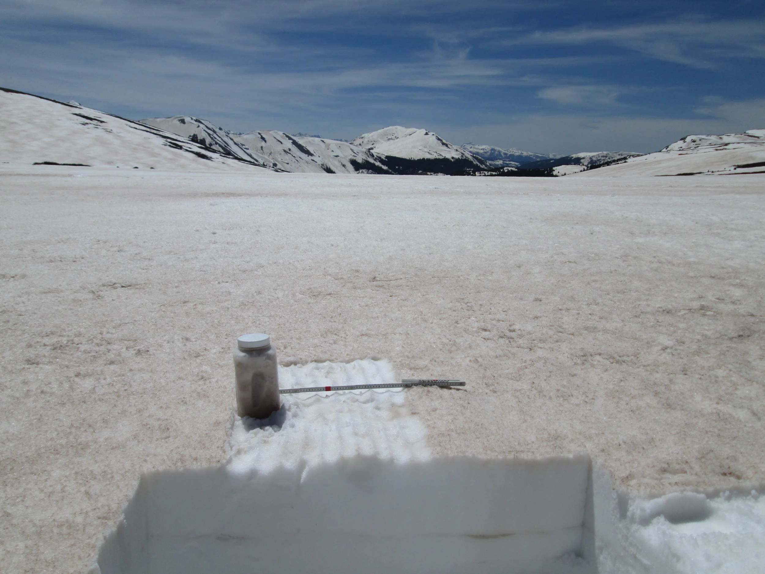
Grand Mesa – June 2, 2014
Open parks on the top of the Grand Mesa were rapidly losing snowcover and generating widespread sheet flow of snowmelt runoff.
Considerable snowpack remained in the dark timber at the Skyway Nordic Ski Trail system, on the approach to the Grand Mesa CODOS site. Spruce beetles are actively attacking this forest, as seen in the two trees on the left of the image.
The only snow remaining in the open meadow at the Grand Mesa CODOS site was surrounding the instrument tower, which was specifically located to capture snow albedo measurements in the last bit of snowcover in that open area. Nearby, but several hundred feet lower, the Mesa Lakes Snotel had recorded ‘snow all gone’ a few days earlier, on May 30.
An ‘all layers merged’ dust sample was collected by scraping the snowpack surface down to the underlying clean snow. Blotches of stained snow remained where very fine dust had infiltrated more deeply into the snowpack, carried by dirty melt water. A layer boundary in the snowpack is also seen where vertically infiltrating dirty melt water was impeded and spread laterally.
Independence Pass – June 2, 2014
The early June date of this final CODOS circuit enabled a special visit to the recently opened Independence Pass, at 12,095’. Although patches of the Memorial Day weekend storm’s clean snow remained, dust was rapidly re-emerging including heavy deposition of the most recent layer D8, the May 11, fawn-colored dust layer logged at Senator Beck Basin and observed extensively during this June 2-4 field circuit.
A fresh “wet slab” avalanche was observed on a north aspect just above the ghost town of Independence. High snowmelt rates produced by dust at the snowpack surface, and the resulting intense flux of free water into the snowpack structure, can contribute to this type of very dangerous spring avalanche activity.
Snowcover was still extensive on the tundra surrounding Independence Pass, here 24” deep. Dust deposition in such alpine terrain exhibits significant spatial variability resulting from wind effects on new snow containing dust., alternately stripping and concentrating dust (and wind-blown snow) in ‘dune’ fields. A typical dune pattern can be seen on the slope on the left, in the distance. An ‘all layers merged’ (ALM) sample was collected in a patch of somewhat higher concentration of dust (than seen just a few yard in the distance), since our purpose with these ALM samples is to facilitate analyses of the dust’s properties rather than to capture a definitive dust mass loading sample. Representative mass loading samples require a well-sheltered site, such as our own Swamp Angel Study Plot at Senator Beck Basin, where wind effects are minimized.
Hoosier Pass and Ten Mile Range – June 3, 2014
Snowcover on Mount Lincoln and Mount Bross, above Montgomery Reservoir, was characteristically patchy, reflecting the intense wind redistribution of snowcover in this locale. Merged dust layers were emerging as the Memorial Day weekend snowfall was receding, again featuring the fawn-colored D8 layer.
Some 27” of snowpack remained at the CODOS Hoosier Pass snow profile site; the re-filled hole from our previous, April 24 snow pit is seen just a few yards to the east. An ‘all layers merged’ dust sample was collected by scraping the surface. As was typical at all sites, dirty melt water infiltrating from the surface had stained snow underneath the sampled snow, and most of the winter’s wind-blown vegetation debris had also accumulated at the snow surface. Still, the vast majority of dust material was captured and will enable analysis of the merged dust properties.
The usual view of Quandary Peak in the distance, as seen from the Hoosier Pass CODOS site, showing the Memorial Day weekend storm clean snow still obscuring most dust.
The fawn-colored dust layer D8, already merged with preceding dust layers, was vividly apparent from Breckenridge and the Blue River valley on the Ten Mile Range, emerging from beneath the Memorial Day weekend clean snow layer.
Grizzly Peak and Loveland Pass – June 3, 2014
Some 32” of “very wet” snow remained at the CODOS snow profile site; the nearby Grizzly Peak Snotel was reporting just 21” at the time. Merged dust layers at the snowpack surface were extensively reducing snow albedo in the Loveland Pass locale, with only small remnants of the clean Memorial Day weekend snowfall remaining. An ‘all layers merged’ sample was collected.
During this site visit, blustery winds occasionally produced blowing dust from the nearby Arapahoe Basin gravel parking lots. A sample of dirt was collected from the parking area, for comparison to the ‘local’ materials (i.e., the non-desert dust) found in the ‘all layers merged’ sample collected in spring 2013.
Dust-in-snow was rapidly re-emerging above treeline, here on the west side of Loveland Pass.
On the east side of Loveland Pass, snowcover reached to and sometimes just below treeline. Dirty snow was also rapidly emerging as the Memorial Day layer of clean snow was quickly ‘burning off’, melted from above by direct solar absorbed in the clean snow surface and from below by solar energy that had penetrated the thinning clean snow layer and been absorbed in the underlying D8 dust layer beneath.
Berthoud Pass – June 3, 2014
Among the ten Snotel stations proximal to our CODOS sites, nine are partially or heavily shaded by surrounding trees. The Berthoud Summit Snotel, on the other hand, is uniquely located in an open meadow with nearly complete exposure to direct solar radiation from the east, south, and west. As a result, Berthoud Summit Snotel SWE and snow depth data reflect the full impact of dust-on-snow on snow albedo and, therefore, on snowmelt rates. The snow pillow measuring SWE is directly beneath the snow depth sensor positioned at the end of the arm extending northward (away from viewer) from the top of the instrument mast. During the sunny period leading up to the June 3 site visit, snowmelt rates rose only slowly from 0.5-1.0” SWE loss per day, with clean snow from the Memorial Day weekend storm still at the snowpack surface and maintaining a comparatively high snow albedo. SWE loss was 1.4” on the day of the site visit, with dust by then widely exposed and snow albedo substantially reduced. Since then, snowmelt rates rose further to 1.8-2.0”/day as merged dust layers D3-8 further consolidated in the snow surface. As of this writing on Monday, June 9, more than half of the snowcover observed on June 3 has melted.
The 35” deep snow pit at Berthoud Summit on June 3 contained 15.5” of SWE, almost exactly matching the SWE being reported at the time by the Snotel just a few yards away. Merged dust containing at least events D3, D4, and D8 was exposed at the surface and an ‘all layers merged’ (ALM) sample was collected from an area measuring 1.00 m x 0.48 m, or 0.48 m2. Dirty melt water from the snow surface had percolated downward in “preferred flow channels” into the underlying clean snowcover before spreading laterally at a layer boundary within the snowpack and creating a layer of dust-stained slush, as seen here a few inches below the surface in the snow pit face. Nonetheless, the ALM sample did capture the vast majority of the merged dust material, for analysis of its chemical and other properties.
Adam Cwiklin, water and wastewater superintendent for the Town of Fraser and a participant in the Colorado Foundation for Water Education’s Water Leaders Program, assisted with the June 3 snow profile at Berthoud Summit. At the time, very high snowmelt rates had driven the Fraser River ‘out of bank’ and generated minor flooding in his service area.
Willow Creek Pass and North Park – June 3, 2014
The Willow Creek Pass CODOS snow pit site had long since lost all snowcover by June 3, and the adjacent Snotel had also just recorded ‘snow all gone’. However, the alpine terrain on Parkview Mountain and other high terrain in the watershed did retain sufficient snowcover to sustain strong flows in Willow Creek (see below).
Willow Creek just a few miles south of Willow Creek Pass.
The characteristic fawn color of dust event D8, from May 11, was apparent on much of the snow surface on this east aspect of Parkview Mountain, interspersed with lingering patches of the Memorial Day weekend clean snowfall.
Streams in the southern (upper) end of North Park were overflowing, hinting at the high runoff being recorded farther north on the USGS North Platte Near Northgate gauge.
The west facing terrain of the Medicine Bow Mountains adjoining North Park retained considerable snow cover on June 3, with dust-on-snow widely exposed.
Rabbit Ears Pass – June 3 and 4, 2014
Open parks on the Rabbit Ears Pass plateau were exhibiting very rapid snowmelt in very dirty snow, generating extensive sheet flow, standing water, and ‘lakes’ of slushy snow, as seen on the late afternoon of June 3.
The CODOS Rabbit Ears CODOS snow pit site is located in a large wet meadow surrounded by heavy and comparatively healthy forest. Evidence of our two prior snowpits is seen in the foreground, at 7:30 AM on June 4.
The often-photographed (by CODOS) headwaters of Walton Creek displayed extensive loss of snowpack. Runnels are seen in the remaining snow, where very rapid snowmelt had produced downslope (versus vertical) “preferred flow channels” for melt water, similar to eroded gullies. Suncupping is also apparent, as pockmarks in the snow surface caused by depressions above vertically oriented “preferred flow paths” for melt water. Dust and reduced snow albedo enhanced both processes in this sunny, southwest-facing terrain.
Considerable snowmelt had occurred at the CODOS site since our prior April 25 visit, reducing snowpack depth from 91” (231 cm) to just 28” (70 cm), 4” of which was ‘liquid snow’ (the dark, standing water at the base of the snowpack, as seen in the pit corner). Snowmelt at the nearby Rabbit Ears Snotel had frequently exceeded 2” of SWE loss per day in the preceding weeks. All dust layers had merged at the snowpack surface and an ‘all layers merged’ sample was collected. Dust layer D8 was present but less dominant at Rabbit Ears Pass than at CODOS sites farther south, somewhat masked by considerable amounts of darker tree debris, accumulated from most of the winter.
McClure Pass – June 4, 2014

As of the June 4 visit the McClure Pass Snotel and adjacent CODOS snow pit site had long since lost all snowcover.
Considerable snowpack remained in alpine terrain in Yule Creek and other Crystal River headwaters, as seen from McClure Pass, and dust was rapidly emerging on even the highest north-facing slopes.
A recent wet slab avalanche on a flank of the north face of Chair Mountain, just south of McClure Pass. Dust layer D8 and other merged dust layers were rapidly re-emerging and may have contributed to this avalanche.
As usual, Paonia Reservoir had very rapidly filled, having been a mere puddle on April 26. Some lingering snowpack remained on the west aspects of the Ragged Mountains, in the distance.
Swamp Angel Study Plot – June 5, 2014
Upon return from the CODOS circuit, the Swamp Angel Study Plot (SASP, at 11,060’) at Senator Beck Basin was on the cusp of “snow all gone” (SAG), with all dust layers D2-D8 merged at the snowpack surface. Dust conditions, dust color, and reductions in snow albedo here were very similar to those observed at Grand Mesa, Independence Pass, and our Front Range CODOS sites. (The snow surface at our Rabbit Ears Pass CODOS site was, if anything, generally darker than this due to accumulated vegetation debris).
Our final snow profile of the season at Swamp Angel Study Plot (SASP) on June 5 documented the loss of almost 30” (75 cm) of snow depth and 13.9” (352 mm) of SWE since the preceding snow profile on May 28. Even with a few lingering inches of clean snowfall from the Memorial Day weekend storm, and that brief restoration of high snow albedo, snowmelt had averaged 1.7” (44mm) of SWE per day during that 8-day interval. Snowmelt around the instrument mast was somewhat more rapid and had already revealed bare ground. The remaining snowcover and 5” of SWE seen in this snow pit was all gone within 48 hours.
Upper Colorado River Basin Snowpack
As of June 4, the combined Upper Colorado River Basin Snotel network SWE plot showed that snowpack was largely consumed and approaching ‘snow all gone’ at the Snotel sites represented. Most remaining snowcover in the watershed was at higher elevations, in alpine terrain or at treeline. Individual Snotel site conditions vary from the plot shown above and we have posted the most current individual Snotel plots available, as of this writing, at our individual CODOS site web pages. On the east side of the Continental Divide, a large fraction remains of the above-average snowpacks recorded at some headwater Snotels such as Joe Wright, Loveland Basin, and University Camp. Dust-on-snow conditions in those headwaters should be assumed to resemble those observed at the Grizzly Peak and Berthoud Summit Snotel sites.
Even with increased cloud cover (and decreased solar potential), snow albedo is very low throughout the Colorado mountains and, aside from occasional hail or snow showers, will remain so until ‘snow all gone’. Snowmelt rates will, therefore, remain higher than average and the remainder of the snowcover will likely be depleted more quickly, at a higher rate of daily SWE loss, than the median trace representing 1981-2010 snowpack ablation on Snotel plots would indicate. The earliest, “minimum” projection of SWE content and eventual ‘snow all gone’ date may best reflect recent dust-enhanced snowmelt rates in these NRCS projection plots.
Hydrographs
As discussed in our May 29 CODOS Alert, snowmelt runoff surging in upper Colorado River watersheds reached very high peak flows in early June, substantially exceeding median peak discharge levels in all watersheds, somewhat earlier than the median average date of peak flow. Although also at a substantially higher level than average, peak flow on the Yampa more closely matched median peak timing. Current hydrographs, as of this writing, are posted at those individual CODOS site webpages.
In all these watersheds, very high, dust-enhanced late-May and early June snowmelt rates were driven by rapidly declining snow albedo, as merged dust-on-snow layers, including layer D8, emerged at all elevations and on all aspects of the remaining snowcover. These very high snowmelt rates and high runoff levels would not have been matched in the absence of dust on the snowcover, given the same weather conditions.
As of this writing, on Monday, June 9, all hydrographs that CODOS normally monitors in those watersheds have now begun reporting declining flows. Several factors including decreasing solar energy inputs caused by increased cloud cover and rapidly decreasing snowcover available for melt could be contributing to those initial declines. Aside from short-lived ‘albedo reset’ episodes caused by fresh hail or snow, current very low snow albedo levels will persist until ‘snow all gone’. Snowmelt rates will remain generally high and the remaining snowpack in these (and all Colorado) watersheds will continue to be depleted at a high rate.
As a result, given normally dry and warm June weather, hydrographs in these and all other Colorado watersheds are unlikely to replicate their median descending limbs. Very high, dust-enhanced snowmelt rates will rapidly consume the declining snowcover. Hydrographs may, as a result, exhibit steeper-than-average descending limbs that initially drop to levels closer to normal peak flows and then, later, to low levels for a given June date, until more normal flows are perhaps restored by monsoonal rains in July and August. Water Year 2006 hydrographs at the Upper Colorado River tributary stations that CODOS monitors provide an example of this steeply descending limb in June following high peak flows – see the hydrograph archives on those specific CODOS site webpages.
Mid-Range Weather Forecast
Generally dry and seasonably warm weather is anticipated to reign over western Colorado for the current week ending June 14, with occasional chances for afternoon showers. NOAA’s Climate Prediction Center outlooks for June 16-22 precipitation and temperatures, issued on June 8, foresee conditions leading up to the summer solstice that could sustain current Colorado snowmelt rates in the snowpack that remains.
WY 2014 Season Summary Reports
Later this summer, after the proverbial dust finally settles, CODOS will prepare and post Water Year 2014 Season Summary reports for each CODOS site, including Senator Beck Basin, appending those reports and updated hydrographs and Snotel data and other analyses to individual CODOS site archival webpages (linked from the top of http://www.codos.org). Once again, we thank our CODOS program funders for your collective support for the Colorado Dust-on-Snow program, and look forward to discussing how the program can continue to support your organizations with useful applied science and information.